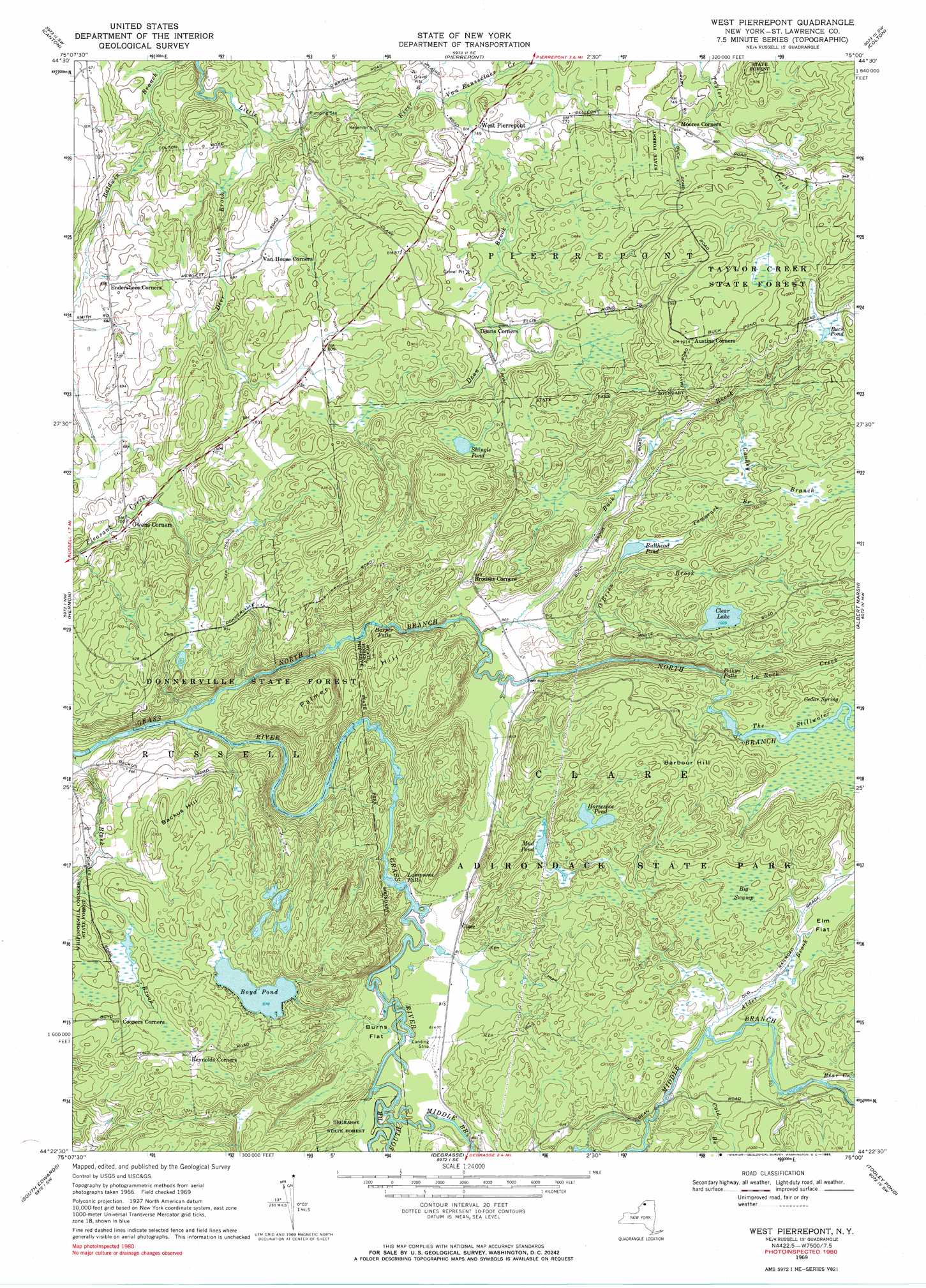
West Pierrepont Topo Map New York
To zoom in, hover over the map of West Pierrepont
USGS Topo Quad 44075d1 - 1:24,000 scale
| Topo Map Name: | West Pierrepont |
| USGS Topo Quad ID: | 44075d1 |
| Print Size: | ca. 21 1/4" wide x 27" high |
| Southeast Coordinates: | 44.375° N latitude / 75° W longitude |
| Map Center Coordinates: | 44.4375° N latitude / 75.0625° W longitude |
| U.S. State: | NY |
| Filename: | o44075d1.jpg |
| Download Map JPG Image: | West Pierrepont topo map 1:24,000 scale |
| Map Type: | Topographic |
| Topo Series: | 7.5´ |
| Map Scale: | 1:24,000 |
| Source of Map Images: | United States Geological Survey (USGS) |
| Alternate Map Versions: |
West Pierrepont NY 1969, updated 1971 Download PDF Buy paper map West Pierrepont NY 1969, updated 1985 Download PDF Buy paper map West Pierrepont NY 2010 Download PDF Buy paper map West Pierrepont NY 2013 Download PDF Buy paper map West Pierrepont NY 2016 Download PDF Buy paper map |
1:24,000 Topo Quads surrounding West Pierrepont
Lisbon |
Morley |
West Potsdam |
Potsdam |
Parishville |
Rensselaer Falls |
Canton |
Pierrepont |
Colton |
Rainbow Falls |
Bigelow |
Hermon |
West Pierrepont |
Albert Marsh |
Stark |
Edwards |
South Edwards |
Degrasse |
Tooley Pond |
Brother Ponds |
Harrisville |
Fine |
Oswegatchie |
Newton Falls |
Cranberry Lake |
> Back to 44075a1 at 1:100,000 scale
> Back to 44074a1 at 1:250,000 scale
> Back to U.S. Topo Maps home
West Pierrepont topo map: Gazetteer
West Pierrepont: Airports
Moores Airport elevation 249m 816′West Pierrepont: Falls
Harper Falls elevation 229m 751′Lampsons Falls elevation 230m 754′
Pelkys Falls elevation 273m 895′
West Pierrepont: Flats
Burns Flat elevation 246m 807′Elm Flat elevation 290m 951′
West Pierrepont: Forests
Donnerville State Forest elevation 269m 882′Taylor Creek State Forest elevation 286m 938′
West Pierrepont: Lakes
Boyd Pond elevation 267m 875′Buck Pond elevation 290m 951′
Bullhead Pond elevation 271m 889′
Clear Lake elevation 307m 1007′
Horseshoe Pond elevation 308m 1010′
Mud Pond elevation 277m 908′
Shingle Pond elevation 277m 908′
West Pierrepont: Populated Places
Clare elevation 250m 820′West Pierrepont elevation 231m 757′
West Pierrepont: Springs
Cedar Spring elevation 289m 948′West Pierrepont: Streams
Alder Brook elevation 275m 902′Bear Creek elevation 286m 938′
Black Brook elevation 179m 587′
Buck Brook elevation 242m 793′
Cold Brook elevation 274m 898′
Conkey Branch elevation 263m 862′
Dean Brook elevation 224m 734′
Deer Lick Brook elevation 180m 590′
La Rock Creek elevation 274m 898′
Middle Branch Grass River elevation 237m 777′
North Branch Grass River elevation 189m 620′
O'Brien Brook elevation 246m 807′
South Branch Grass River elevation 239m 784′
Tamarack Branch elevation 268m 879′
The Stillwater elevation 286m 938′
Van Rensselaer Creek elevation 224m 734′
West Pierrepont: Summits
Backus Hill elevation 299m 980′Barbour Hill elevation 340m 1115′
Palmer Hill elevation 306m 1003′
West Pierrepont: Swamps
Big Swamp elevation 302m 990′West Pierrepont digital topo map on disk
Buy this West Pierrepont topo map showing relief, roads, GPS coordinates and other geographical features, as a high-resolution digital map file on DVD:
New York, Vermont, Connecticut & Western Massachusetts
Buy digital topo maps: New York, Vermont, Connecticut & Western Massachusetts