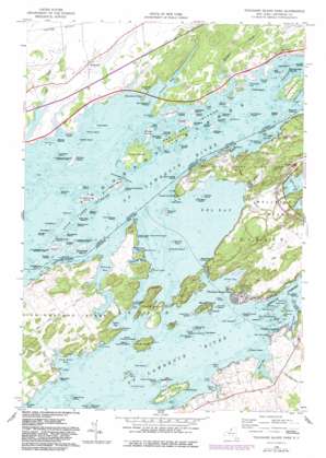
Thousand Island Park Topo Map New York
To zoom in, hover over the map of Thousand Island Park
USGS Topo Quad 44076c1 - 1:24,000 scale
| Topo Map Name: | Thousand Island Park |
| USGS Topo Quad ID: | 44076c1 |
| Print Size: | ca. 21 1/4" wide x 27" high |
| Southeast Coordinates: | 44.25° N latitude / 76° W longitude |
| Map Center Coordinates: | 44.3125° N latitude / 76.0625° W longitude |
| U.S. State: | NY |
| Filename: | o44076c1.jpg |
| Download Map JPG Image: | Thousand Island Park topo map 1:24,000 scale |
| Map Type: | Topographic |
| Topo Series: | 7.5´ |
| Map Scale: | 1:24,000 |
| Source of Map Images: | United States Geological Survey (USGS) |
| Alternate Map Versions: |
Thousand Island Park NY 1958, updated 1960 Download PDF Buy paper map Thousand Island Park NY 1958, updated 1960 Download PDF Buy paper map Thousand Island Park NY 1958, updated 1983 Download PDF Buy paper map Thousand Island Park NY 2011 Download PDF Buy paper map Thousand Island Park NY 2013 Download PDF Buy paper map Thousand Island Park NY 2016 Download PDF Buy paper map |
1:24,000 Topo Quads surrounding Thousand Island Park
Chippewa Bay |
||||
Gananoque |
Thousand Island Park |
Alexandria Bay |
Redwood |
|
Cape Vincent North |
Saint Lawrence |
Clayton |
La Fargeville |
Theresa |
Cape Vincent South |
Chaumont |
Dexter |
Brownville |
Black River |
> Back to 44076a1 at 1:100,000 scale
> Back to 44076a1 at 1:250,000 scale
> Back to U.S. Topo Maps home
Thousand Island Park topo map: Gazetteer
Thousand Island Park: Bars
Chapman Shoal elevation 74m 242′Niagra Shoal elevation 74m 242′
Rock Island Reef elevation 74m 242′
Thousand Island Park: Bays
Aunt Janes Bay elevation 74m 242′Delaney Bay elevation 74m 242′
Eel Bay elevation 74m 242′
Mullet Creek Bay elevation 74m 242′
Rusho Bay elevation 74m 242′
South Bay elevation 74m 242′
Spicer Bay elevation 74m 242′
Thousand Island Park: Capes
Bradley Point elevation 74m 242′Canoe Point elevation 74m 242′
Grass Point elevation 74m 242′
Grossman Point elevation 74m 242′
Irwin Point elevation 78m 255′
Mason Point elevation 77m 252′
Murdoch Point elevation 82m 269′
Picnic Point elevation 75m 246′
Point Angiers elevation 76m 249′
Reed Point elevation 76m 249′
Swiftwater Point elevation 76m 249′
Thousand Island Park: Channels
The Narrows elevation 74m 242′Thousand Island Park: Harbors
Spicer Marine Basin elevation 74m 242′Thousand Island Park: Islands
Basswood Island elevation 75m 246′Big Gull Island elevation 75m 246′
Bluff Island elevation 98m 321′
Boscobel Island elevation 75m 246′
Calumet Island elevation 77m 252′
Castle Francis Island elevation 76m 249′
Cedar Island elevation 77m 252′
Crow Island elevation 74m 242′
Eagle Wing Group elevation 74m 242′
Flatiron Island elevation 75m 246′
Frederick Island elevation 77m 252′
Grenell Island elevation 98m 321′
Grindstone Island elevation 87m 285′
Gull Island elevation 74m 242′
Hub Island elevation 80m 262′
Isle of Pines elevation 79m 259′
Lasalle Island elevation 76m 249′
Lees Island elevation 74m 242′
Little Basswood Island elevation 76m 249′
Little Gull Island elevation 74m 242′
Little Round Island elevation 78m 255′
Long Rock Island elevation 79m 259′
Mandolin Island elevation 76m 249′
Maple Island elevation 92m 301′
Mosquito Island elevation 75m 246′
Murray Isle elevation 99m 324′
North Colborne Island elevation 76m 249′
North Crawford Island elevation 74m 242′
Orient Island elevation 77m 252′
Picton Island elevation 93m 305′
Pine Island elevation 88m 288′
Pullman Island elevation 77m 252′
Robinson Group elevation 82m 269′
Rock Island elevation 78m 255′
Round Island elevation 83m 272′
Rylstone Isle elevation 77m 252′
Sargent Island elevation 80m 262′
Smugglers Island elevation 76m 249′
Susan Island elevation 76m 249′
Tidd Island elevation 74m 242′
Twin Island elevation 76m 249′
Vanderbilt Island elevation 79m 259′
Watch Island elevation 77m 252′
Wellesley Island elevation 89m 291′
West Crawford Island elevation 75m 246′
Winter Island elevation 76m 249′
Woronoco Island elevation 77m 252′
Thousand Island Park: Parks
Canoe Point and Picnic Point State Park elevation 77m 252′Waterson Point Park elevation 86m 282′
Wellesley Island State Park elevation 96m 314′
Thousand Island Park: Populated Places
Fineview elevation 86m 282′Fishers Landing elevation 80m 262′
Frontenac elevation 74m 242′
Grandview Park elevation 82m 269′
Grenell elevation 98m 321′
Lower Town Landing elevation 79m 259′
Thousand Island Park elevation 84m 275′
Upper Town Landing elevation 82m 269′
Thousand Island Park: Streams
Mullet Creek elevation 74m 242′Thousand Island Park: Swamps
Blind Bay elevation 74m 242′Plumtree Marsh elevation 74m 242′
Whitehouse Marsh elevation 74m 242′
Thousand Island Park digital topo map on disk
Buy this Thousand Island Park topo map showing relief, roads, GPS coordinates and other geographical features, as a high-resolution digital map file on DVD:
New York, Vermont, Connecticut & Western Massachusetts
Buy digital topo maps: New York, Vermont, Connecticut & Western Massachusetts


