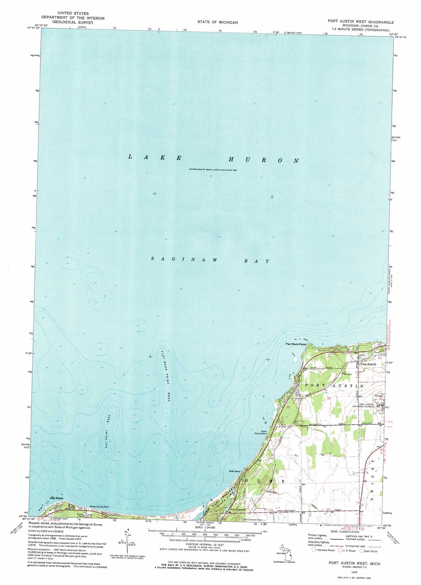
Port Austin West Topo Map Michigan
To zoom in, hover over the map of Port Austin West
USGS Topo Quad 44083a1 - 1:24,000 scale
| Topo Map Name: | Port Austin West |
| USGS Topo Quad ID: | 44083a1 |
| Print Size: | ca. 21 1/4" wide x 27" high |
| Southeast Coordinates: | 44° N latitude / 83° W longitude |
| Map Center Coordinates: | 44.0625° N latitude / 83.0625° W longitude |
| U.S. State: | MI |
| Filename: | o44083a1.jpg |
| Download Map JPG Image: | Port Austin West topo map 1:24,000 scale |
| Map Type: | Topographic |
| Topo Series: | 7.5´ |
| Map Scale: | 1:24,000 |
| Source of Map Images: | United States Geological Survey (USGS) |
| Alternate Map Versions: |
Port Austin West MI 1970, updated 1973 Download PDF Buy paper map Port Austin West MI 2011 Download PDF Buy paper map Port Austin West MI 2014 Download PDF Buy paper map Port Austin West MI 2016 Download PDF Buy paper map |
1:24,000 Topo Quads surrounding Port Austin West
Spencer Lake |
||||
Port Austin West |
Port Austin East |
Huron City |
||
Caseville |
Rush Lake |
Kinde West |
Kinde East |
Redman |
Bay Port East |
Elkton |
Bad Axe West |
Bad Axe East |
Bad Axe Se |
> Back to 44083a1 at 1:100,000 scale
> Back to 44082a1 at 1:250,000 scale
> Back to U.S. Topo Maps home
Port Austin West topo map: Gazetteer
Port Austin West: Bars
Flat Rock Point Reef elevation 177m 580′Hat Point Reef elevation 177m 580′
Port Austin West: Canals
Ahearn Drain elevation 193m 633′Port Austin West: Capes
Flat Rock Point elevation 180m 590′Hat Point elevation 180m 590′
Port Austin West: Parks
Jenks County Park elevation 180m 590′Philp Park elevation 180m 590′
Port Crescent State Park elevation 180m 590′
Port Austin West: Populated Places
Hiawatha Trailer Park elevation 180m 590′Port Crescent elevation 181m 593′
Port Austin West: Post Offices
Port Crescent Post Office (historical) elevation 181m 593′Port Austin West: Streams
Pinnebog River elevation 177m 580′Port Austin West digital topo map on disk
Buy this Port Austin West topo map showing relief, roads, GPS coordinates and other geographical features, as a high-resolution digital map file on DVD:
 map DVD")