East Tawas Topo Map Michigan
To zoom in, hover over the map of East Tawas
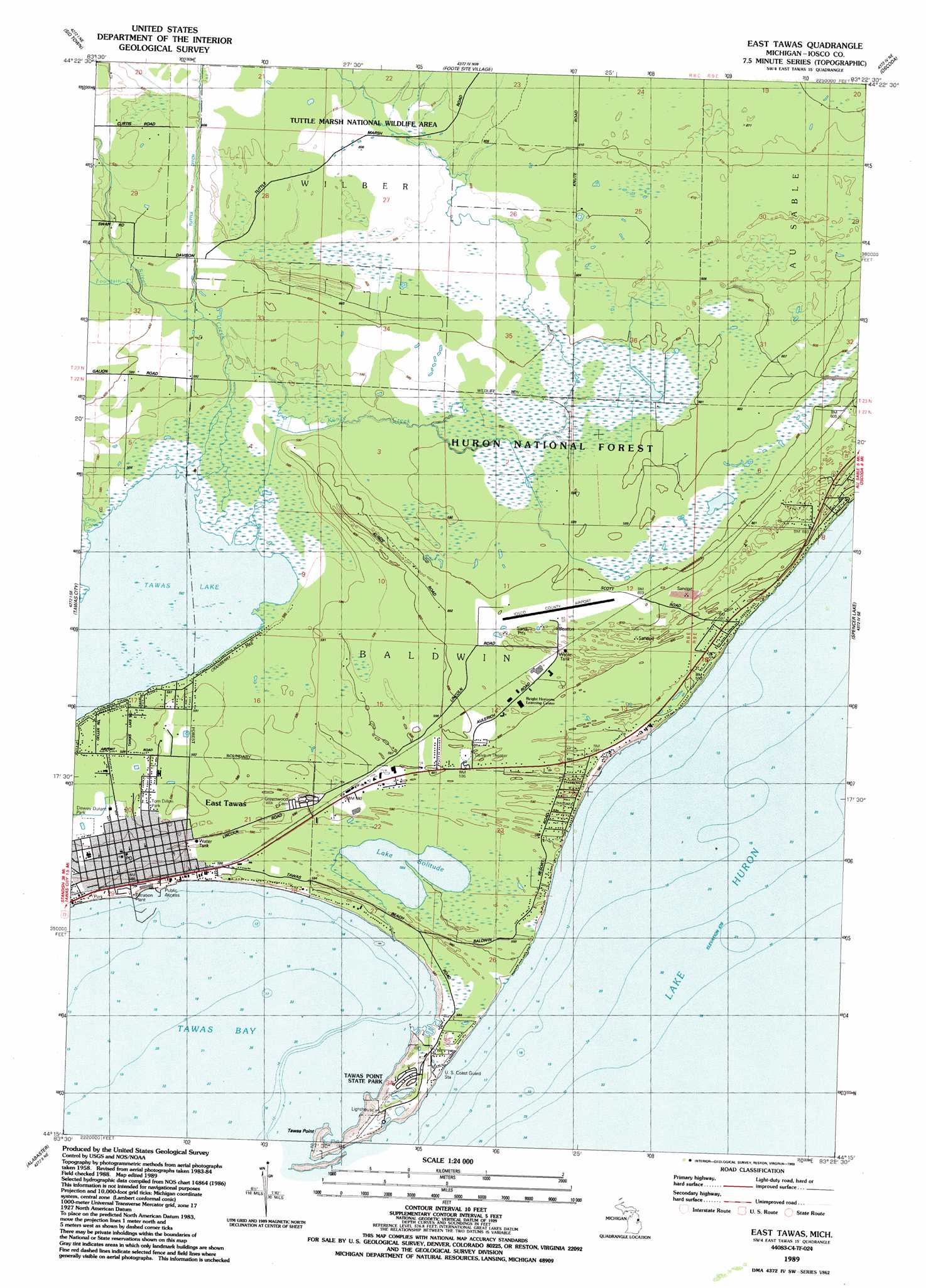
USGS Topo Quad 44083c4 - 1:24,000 scale
| Topo Map Name: | East Tawas |
| USGS Topo Quad ID: | 44083c4 |
| Print Size: | ca. 21 1/4" wide x 27" high |
| Southeast Coordinates: | 44.25° N latitude / 83.375° W longitude |
| Map Center Coordinates: | 44.3125° N latitude / 83.4375° W longitude |
| U.S. State: | MI |
| Filename: | o44083c4.jpg |
| Download Map JPG Image: | East Tawas topo map 1:24,000 scale |
| Map Type: | Topographic |
| Topo Series: | 7.5´ |
| Map Scale: | 1:24,000 |
| Source of Map Images: | United States Geological Survey (USGS) |
| Alternate Map Versions: |
East Tawas MI 1989, updated 1989 Download PDF Buy paper map East Tawas MI 2012 Download PDF Buy paper map East Tawas MI 2014 Download PDF Buy paper map East Tawas MI 2016 Download PDF Buy paper map |
| FStopo: | US Forest Service topo East Tawas is available: Download FStopo PDF Download FStopo TIF |
1:24,000 Topo Quads surrounding East Tawas
Glennie |
Sprinkler Creek |
Mikado |
Greenbush |
|
Loud Dam |
Sid Town |
Foote Site Village |
Oscoda |
|
Floyd Lake |
Tawas City |
East Tawas |
Spencer Lake |
|
National City |
Alabaster |
|||
Au Gres |
Point Lookout |
Charity Island |
> Back to 44083a1 at 1:100,000 scale
> Back to 44082a1 at 1:250,000 scale
> Back to U.S. Topo Maps home
East Tawas topo map: Gazetteer
East Tawas: Airports
Iosco County Airport elevation 185m 606′East Tawas: Bays
Tawas Bay elevation 177m 580′East Tawas: Canals
Tuttle Ditch elevation 181m 593′East Tawas: Lakes
Lake Solitude elevation 178m 583′Tawas Lake elevation 177m 580′
East Tawas: Parks
Bolen Park elevation 179m 587′Dewey Durant Park elevation 179m 587′
East Tawas City Park elevation 178m 583′
Lumbering on the Huron Shore Historical Marker elevation 180m 590′
Tawas Point State Park elevation 177m 580′
Tom Dillon Park elevation 180m 590′
Tuttle Marsh National Wildlife Area elevation 185m 606′
East Tawas: Populated Places
East Tawas elevation 178m 583′East Tawas: Post Offices
East Tawas Post Office elevation 180m 590′Tawa Beach Post Office (historical) elevation 179m 587′
East Tawas: Streams
Fountain Creek elevation 183m 600′Gray Creek elevation 178m 583′
Kunze Creek elevation 177m 580′
Silver Creek elevation 177m 580′
East Tawas digital topo map on disk
Buy this East Tawas topo map showing relief, roads, GPS coordinates and other geographical features, as a high-resolution digital map file on DVD:
 map DVD")