South Branch Topo Map Michigan
To zoom in, hover over the map of South Branch
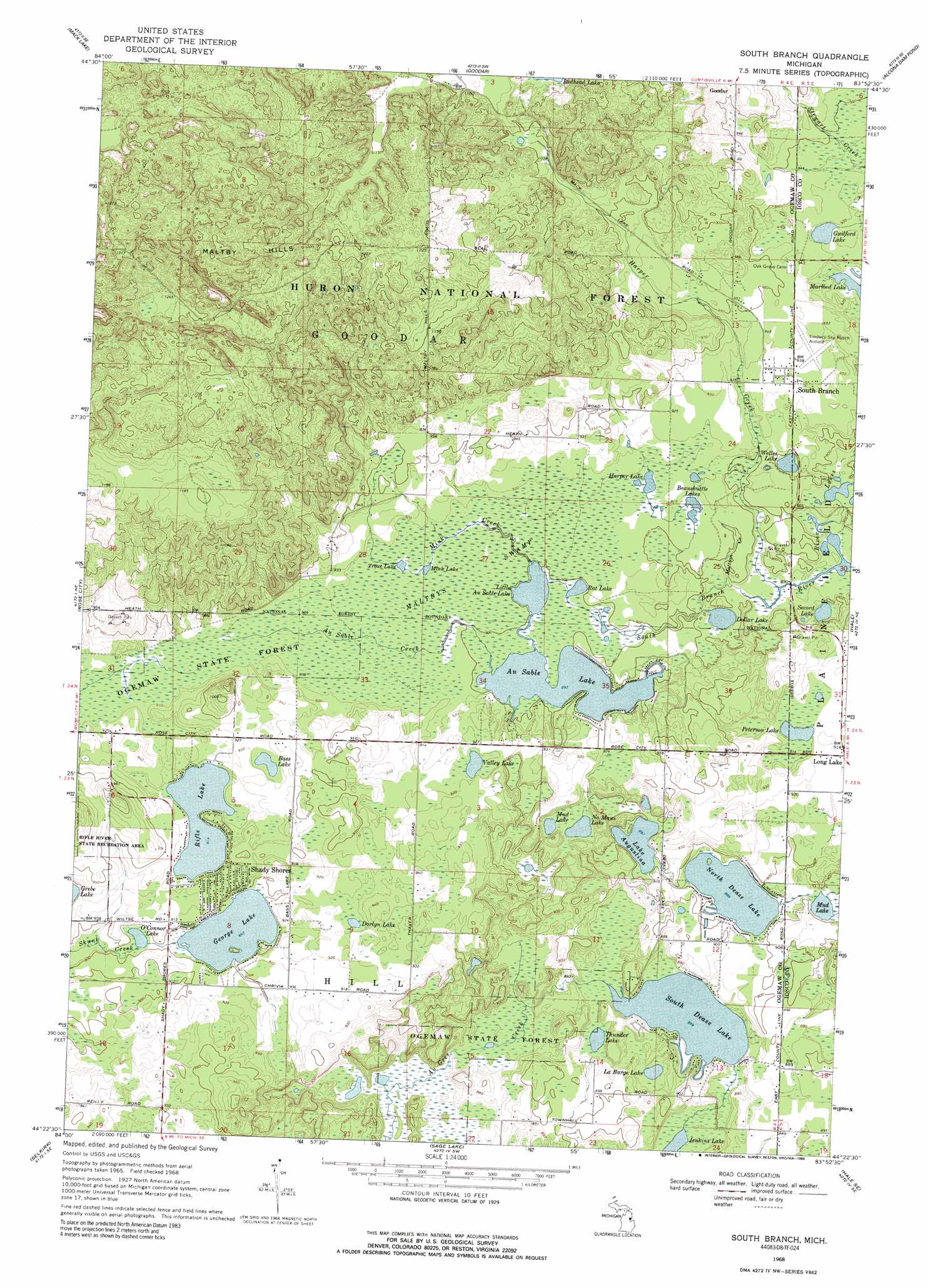
USGS Topo Quad 44083d8 - 1:24,000 scale
| Topo Map Name: | South Branch |
| USGS Topo Quad ID: | 44083d8 |
| Print Size: | ca. 21 1/4" wide x 27" high |
| Southeast Coordinates: | 44.375° N latitude / 83.875° W longitude |
| Map Center Coordinates: | 44.4375° N latitude / 83.9375° W longitude |
| U.S. State: | MI |
| Filename: | o44083d8.jpg |
| Download Map JPG Image: | South Branch topo map 1:24,000 scale |
| Map Type: | Topographic |
| Topo Series: | 7.5´ |
| Map Scale: | 1:24,000 |
| Source of Map Images: | United States Geological Survey (USGS) |
| Alternate Map Versions: |
South Branch MI 1968, updated 1971 Download PDF Buy paper map South Branch MI 1968, updated 1989 Download PDF Buy paper map South Branch MI 2012 Download PDF Buy paper map South Branch MI 2014 Download PDF Buy paper map South Branch MI 2016 Download PDF Buy paper map |
| FStopo: | US Forest Service topo South Branch is available: Download FStopo PDF Download FStopo TIF |
1:24,000 Topo Quads surrounding South Branch
Mio |
Fairview |
Mckinley |
Curran |
Bucks Pond |
Island Lake |
Mack Lake |
Goodar |
Alcona Dam Pond |
Glennie |
Damon |
Rose City |
South Branch |
Hale |
Loud Dam |
West Branch |
Selkirk |
Sage Lake |
Hale Se |
Floyd Lake |
Sterling Nw |
Skidway Lake |
Prescott |
Whittemore |
National City |
> Back to 44083a1 at 1:100,000 scale
> Back to 44082a1 at 1:250,000 scale
> Back to U.S. Topo Maps home
South Branch topo map: Gazetteer
South Branch: Airports
Junior North Heliport elevation 286m 938′Timbers Sky Camp Airport elevation 285m 935′
South Branch: Lakes
Au Sable Lake elevation 273m 895′Bass Lake elevation 282m 925′
Beanshuttle Lakes elevation 276m 905′
Darlyn Lake elevation 279m 915′
Dollar Lake elevation 270m 885′
George Lake elevation 272m 892′
Guilford Lake elevation 282m 925′
Harper Lake elevation 276m 905′
La Barge Lake elevation 263m 862′
Lake Augustina elevation 273m 895′
Little Au Sable Lake elevation 273m 895′
Mink Lake elevation 275m 902′
Mud Lake elevation 276m 905′
Mud Lake elevation 269m 882′
No Mans Lake elevation 275m 902′
North Dease Lake elevation 271m 889′
O'Connor Lake elevation 272m 892′
Peterson Lake elevation 276m 905′
Rat Lake elevation 273m 895′
Rifle Lake elevation 278m 912′
River Lakes elevation 270m 885′
Secord Lake elevation 270m 885′
South Dease Lake elevation 262m 859′
Thunder Lake elevation 260m 853′
Trout Lake elevation 276m 905′
Valley Lake elevation 279m 915′
Welles Lake elevation 273m 895′
South Branch: Parks
Rose Township District Number Five School Historical Marker elevation 281m 921′South Branch: Populated Places
Shady Shores elevation 287m 941′South Branch elevation 285m 935′
South Branch: Post Offices
Maltby Post Office (historical) elevation 283m 928′South Branch Post Office elevation 285m 935′
South Branch: Streams
Au Sable Creek elevation 273m 895′Harper Creek elevation 269m 882′
Mattson Creek elevation 270m 885′
Mink Creek elevation 274m 898′
South Branch: Swamps
Maltbys Swamp elevation 275m 902′South Branch digital topo map on disk
Buy this South Branch topo map showing relief, roads, GPS coordinates and other geographical features, as a high-resolution digital map file on DVD:
 map DVD")