Bucks Pond Topo Map Michigan
To zoom in, hover over the map of Bucks Pond
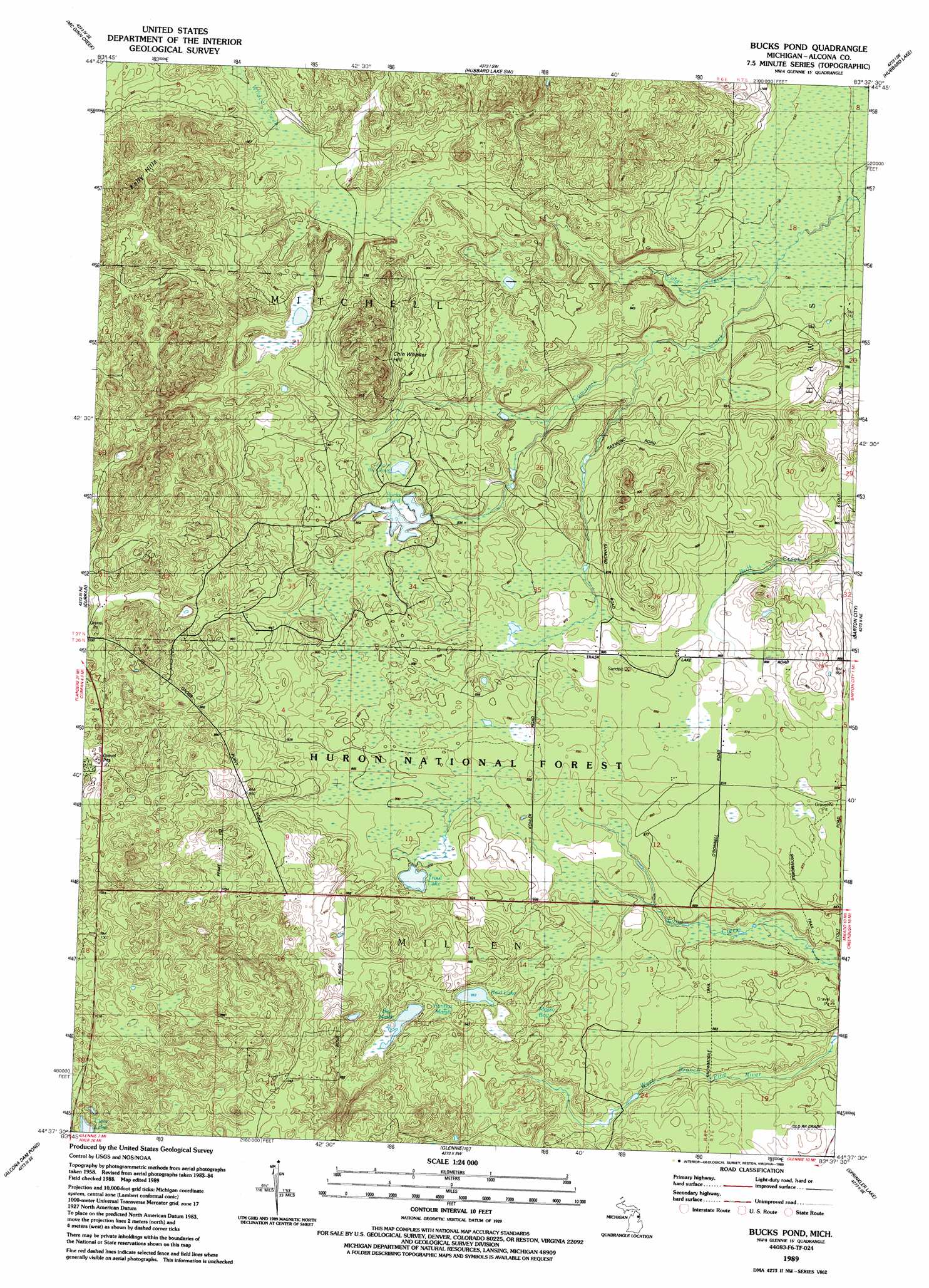
USGS Topo Quad 44083f6 - 1:24,000 scale
| Topo Map Name: | Bucks Pond |
| USGS Topo Quad ID: | 44083f6 |
| Print Size: | ca. 21 1/4" wide x 27" high |
| Southeast Coordinates: | 44.625° N latitude / 83.625° W longitude |
| Map Center Coordinates: | 44.6875° N latitude / 83.6875° W longitude |
| U.S. State: | MI |
| Filename: | o44083f6.jpg |
| Download Map JPG Image: | Bucks Pond topo map 1:24,000 scale |
| Map Type: | Topographic |
| Topo Series: | 7.5´ |
| Map Scale: | 1:24,000 |
| Source of Map Images: | United States Geological Survey (USGS) |
| Alternate Map Versions: |
Bucks Pond MI 1989, updated 1989 Download PDF Buy paper map Bucks Pond MI 2012 Download PDF Buy paper map Bucks Pond MI 2014 Download PDF Buy paper map Bucks Pond MI 2016 Download PDF Buy paper map |
| FStopo: | US Forest Service topo Bucks Pond is available: Download FStopo PDF Download FStopo TIF |
1:24,000 Topo Quads surrounding Bucks Pond
Rust |
Beaver Lake |
Evans Creek |
Big Ravine Creek |
Ossineke |
Mccollum Lake |
Mcginn Creek |
Hubbard Lake Sw |
Hubbard Lake |
Spruce |
Mckinley |
Curran |
Bucks Pond |
Barton City |
Lincoln |
Goodar |
Alcona Dam Pond |
Glennie |
Sprinkler Creek |
Mikado |
South Branch |
Hale |
Loud Dam |
Sid Town |
Foote Site Village |
> Back to 44083e1 at 1:100,000 scale
> Back to 44082a1 at 1:250,000 scale
> Back to U.S. Topo Maps home
Bucks Pond topo map: Gazetteer
Bucks Pond: Airports
Circle T Ranch Airport elevation 304m 997′Bucks Pond: Lakes
Bucks Pond elevation 260m 853′Clear Lake elevation 287m 941′
Lake in the Green elevation 264m 866′
Reid Lake elevation 277m 908′
Trout Lake elevation 273m 895′
Bucks Pond: Streams
Cold Creek elevation 221m 725′Bucks Pond: Summits
Chin Whisker Hill elevation 318m 1043′Kelly Hills elevation 328m 1076′
Bucks Pond: Swamps
Big Marsh elevation 282m 925′Fannys Marsh elevation 279m 915′
Mossy Bog elevation 273m 895′
Bucks Pond digital topo map on disk
Buy this Bucks Pond topo map showing relief, roads, GPS coordinates and other geographical features, as a high-resolution digital map file on DVD:
 map DVD")