Island Lake Topo Map Michigan
To zoom in, hover over the map of Island Lake
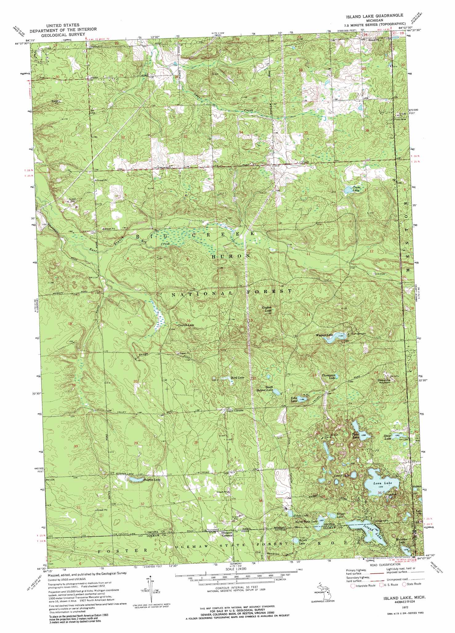
USGS Topo Quad 44084e2 - 1:24,000 scale
| Topo Map Name: | Island Lake |
| USGS Topo Quad ID: | 44084e2 |
| Print Size: | ca. 21 1/4" wide x 27" high |
| Southeast Coordinates: | 44.5° N latitude / 84.125° W longitude |
| Map Center Coordinates: | 44.5625° N latitude / 84.1875° W longitude |
| U.S. State: | MI |
| Filename: | o44084e2.jpg |
| Download Map JPG Image: | Island Lake topo map 1:24,000 scale |
| Map Type: | Topographic |
| Topo Series: | 7.5´ |
| Map Scale: | 1:24,000 |
| Source of Map Images: | United States Geological Survey (USGS) |
| Alternate Map Versions: |
Island Lake MI 1972, updated 1975 Download PDF Buy paper map Island Lake MI 1972, updated 1989 Download PDF Buy paper map Island Lake MI 2012 Download PDF Buy paper map Island Lake MI 2014 Download PDF Buy paper map Island Lake MI 2017 Download PDF Buy paper map |
| FStopo: | US Forest Service topo Island Lake is available: Download FStopo PDF Download FStopo TIF |
1:24,000 Topo Quads surrounding Island Lake
Lovells |
Comstock Hills |
Oak Lake |
Comins |
Mccollum Lake |
Luzerne Nw |
Red Oak |
Mio |
Fairview |
Mckinley |
Eldorado |
Luzerne |
Island Lake |
Mack Lake |
Goodar |
Saint Helen Nw |
Saint Helen Ne |
Damon |
Rose City |
South Branch |
Saint Helen |
Ogemaw Springs |
West Branch |
Selkirk |
Sage Lake |
> Back to 44084e1 at 1:100,000 scale
> Back to 44084a1 at 1:250,000 scale
> Back to U.S. Topo Maps home
Island Lake topo map: Gazetteer
Island Lake: Lakes
Abbott Lake elevation 376m 1233′Bird Lake elevation 351m 1151′
Briggs Lake elevation 386m 1266′
Crane Lake elevation 362m 1187′
Crater Lake elevation 366m 1200′
Echo Lake elevation 361m 1184′
Hidden Lake elevation 385m 1263′
Hughes Lake elevation 361m 1184′
Island Lake elevation 391m 1282′
Loon Lake elevation 373m 1223′
Muleshoe Lake elevation 390m 1279′
North Twin Lake elevation 382m 1253′
Shaw Lake elevation 385m 1263′
Silvis Lake elevation 392m 1286′
South Helmer Lake elevation 375m 1230′
Thompson Lake elevation 376m 1233′
Twin Lake elevation 375m 1230′
Wagner Lake elevation 342m 1122′
Island Lake: Post Offices
Indian Lake Post Office (historical) elevation 332m 1089′Island Lake: Summits
Timberline Mountain elevation 378m 1240′Island Lake: Swamps
Church Lake elevation 346m 1135′Gopher Lake elevation 341m 1118′
Island Lake digital topo map on disk
Buy this Island Lake topo map showing relief, roads, GPS coordinates and other geographical features, as a high-resolution digital map file on DVD: