Comins Topo Map Michigan
To zoom in, hover over the map of Comins
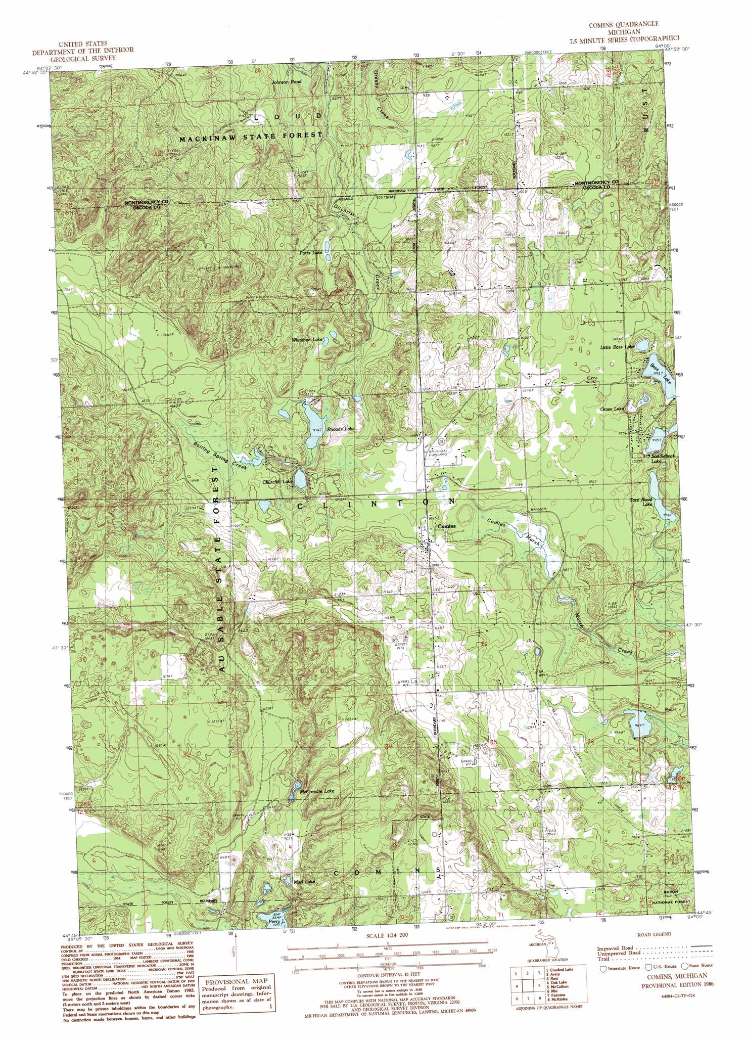
USGS Topo Quad 44084g1 - 1:24,000 scale
| Topo Map Name: | Comins |
| USGS Topo Quad ID: | 44084g1 |
| Print Size: | ca. 21 1/4" wide x 27" high |
| Southeast Coordinates: | 44.75° N latitude / 84° W longitude |
| Map Center Coordinates: | 44.8125° N latitude / 84.0625° W longitude |
| U.S. State: | MI |
| Filename: | o44084g1.jpg |
| Download Map JPG Image: | Comins topo map 1:24,000 scale |
| Map Type: | Topographic |
| Topo Series: | 7.5´ |
| Map Scale: | 1:24,000 |
| Source of Map Images: | United States Geological Survey (USGS) |
| Alternate Map Versions: |
Comins MI 1986, updated 1986 Download PDF Buy paper map Comins MI 2012 Download PDF Buy paper map Comins MI 2014 Download PDF Buy paper map Comins MI 2017 Download PDF Buy paper map |
| FStopo: | US Forest Service topo Comins is available: Download FStopo PDF Download FStopo TIF |
1:24,000 Topo Quads surrounding Comins
Hetherton |
Atlanta |
Atlanta Se |
Hillman |
Jewett Creek |
Lewiston |
Crooked Lake |
Avery |
Rust |
Beaver Lake |
Comstock Hills |
Oak Lake |
Comins |
Mccollum Lake |
Mcginn Creek |
Red Oak |
Mio |
Fairview |
Mckinley |
Curran |
Luzerne |
Island Lake |
Mack Lake |
Goodar |
Alcona Dam Pond |
> Back to 44084e1 at 1:100,000 scale
> Back to 44084a1 at 1:250,000 scale
> Back to U.S. Topo Maps home
Comins topo map: Gazetteer
Comins: Lakes
Bass Lake elevation 304m 997′Churchill Lake elevation 300m 984′
Grass Lake elevation 304m 997′
Johnson Pond elevation 261m 856′
Little Bass Lake elevation 303m 994′
McCreedie Lake elevation 334m 1095′
Mud Lake elevation 331m 1085′
Pots Lake elevation 282m 925′
Rhoads Lake elevation 297m 974′
Tote Road Lake elevation 304m 997′
Whitabee Lake elevation 301m 987′
Comins: Populated Places
Comins elevation 319m 1046′Comins: Post Offices
Comins Post Office elevation 319m 1046′Comins: Springs
Boiling Springs elevation 315m 1033′Comins: Streams
Boiling Spring Creek elevation 312m 1023′Comins: Swamps
Comins Marsh elevation 307m 1007′Comins digital topo map on disk
Buy this Comins topo map showing relief, roads, GPS coordinates and other geographical features, as a high-resolution digital map file on DVD: