Le Roy Topo Map Michigan
To zoom in, hover over the map of Le Roy
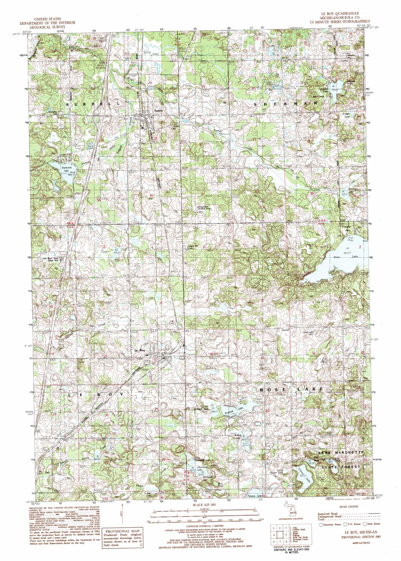
USGS Topo Quad 44085a4 - 1:25,000 scale
| Topo Map Name: | Le Roy |
| USGS Topo Quad ID: | 44085a4 |
| Print Size: | ca. 21 1/4" wide x 27" high |
| Southeast Coordinates: | 44° N latitude / 85.375° W longitude |
| Map Center Coordinates: | 44.0625° N latitude / 85.4375° W longitude |
| U.S. State: | MI |
| Filename: | l44085a4.jpg |
| Download Map JPG Image: | Le Roy topo map 1:25,000 scale |
| Map Type: | Topographic |
| Topo Series: | 7.5´ |
| Map Scale: | 1:25,000 |
| Source of Map Images: | United States Geological Survey (USGS) |
| Alternate Map Versions: |
Le Roy MI 1983, updated 1984 Download PDF Buy paper map |
1:24,000 Topo Quads surrounding Le Roy
Harrieta |
Boon |
Cadillac North |
Jennings |
Lake City |
Luther Nw |
Luther Ne |
Cadillac South |
Lucas |
Mcbain |
Luther Sw |
Luther Se |
Le Roy |
Dighton |
Marion |
Chase |
Reed City North |
Slaybaugh Corner |
Evart |
Sears |
Whipple Lake |
Reed City South |
Hersey |
Chippewa Lake North |
Merrill Lake |
> Back to 44085a1 at 1:100,000 scale
> Back to 44084a1 at 1:250,000 scale
> Back to U.S. Topo Maps home
Le Roy topo map: Gazetteer
Le Roy: Airports
McQuestions Airport elevation 402m 1318′Le Roy: Crossings
Interchange 168 elevation 375m 1230′Le Roy: Lakes
Boot Lake elevation 374m 1227′Center Lake elevation 397m 1302′
Deer Lake elevation 362m 1187′
Diamond Lake elevation 370m 1213′
Emery Lake elevation 380m 1246′
Hogback Lake elevation 379m 1243′
Little Hogback Lake elevation 379m 1243′
Little Sherwood Lake elevation 368m 1207′
Little Silver Lake elevation 371m 1217′
McCoy Lake elevation 376m 1233′
Mud Lake elevation 371m 1217′
Noggle Lake elevation 395m 1295′
Penasa Lake elevation 376m 1233′
Rice Lake elevation 374m 1227′
Rose Lake elevation 382m 1253′
Sherwood Lake elevation 367m 1204′
Silver Lake elevation 370m 1213′
Sprague Lake elevation 367m 1204′
Le Roy: Oilfields
Mineral Springs Oil Field elevation 378m 1240′Le Roy: Parks
John E Larson Farm Historical Marker elevation 375m 1230′Rose Lake Park elevation 390m 1279′
Swedish Evangelical Lutheran Church Historical Marker elevation 389m 1276′
Unto a New Land Historical Marker elevation 375m 1230′
Le Roy: Populated Places
Le Roy elevation 384m 1259′Tustin elevation 374m 1227′
Le Roy: Post Offices
Le Roy Post Office elevation 386m 1266′Tustin Post Office elevation 375m 1230′
Le Roy: Streams
Diamond Lake Outlet Creek elevation 364m 1194′Lake Outlet elevation 362m 1187′
Le Roy digital topo map on disk
Buy this Le Roy topo map showing relief, roads, GPS coordinates and other geographical features, as a high-resolution digital map file on DVD: