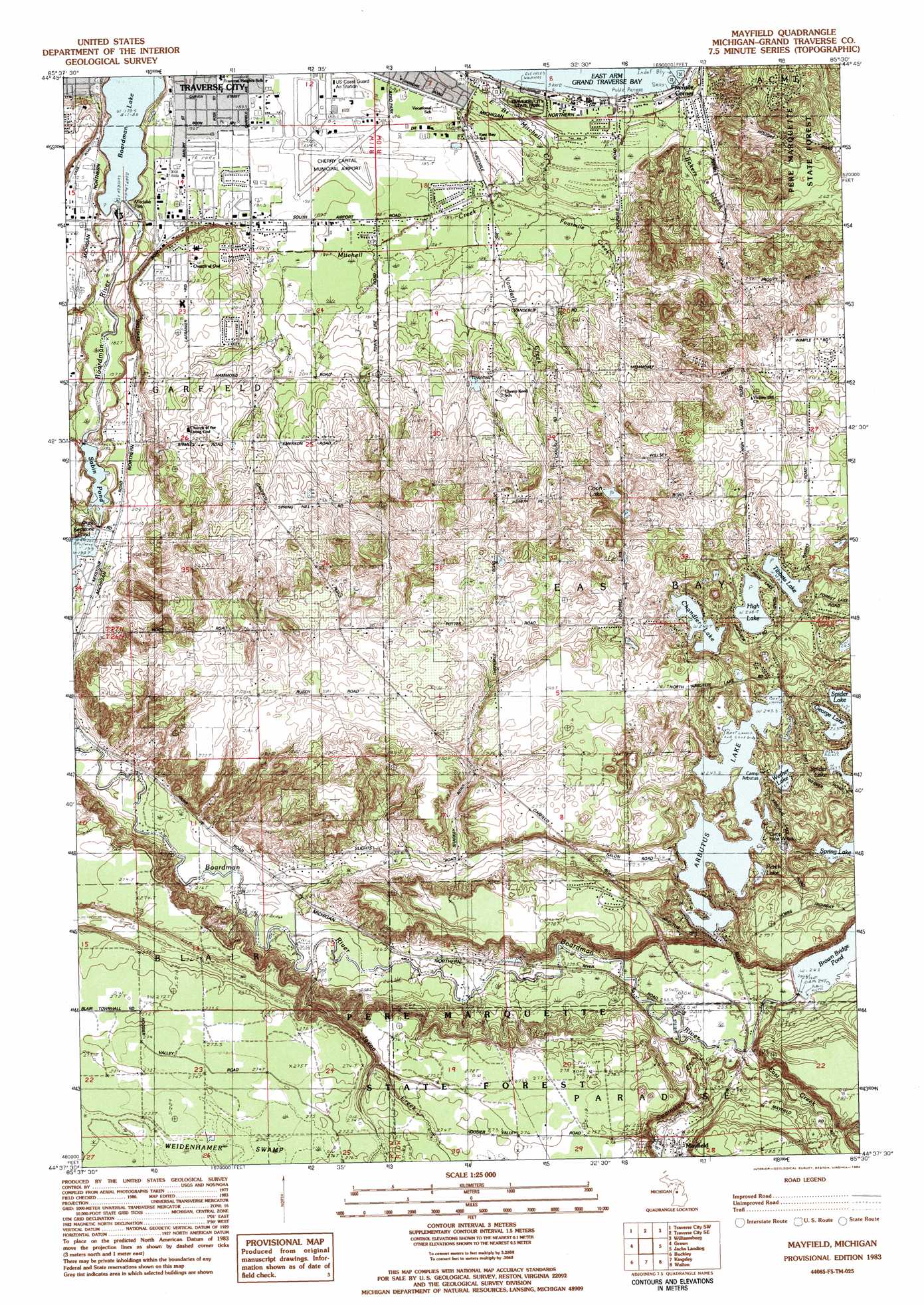
Mayfield Topo Map Michigan
To zoom in, hover over the map of Mayfield
USGS Topo Quad 44085f5 - 1:25,000 scale
| Topo Map Name: | Mayfield |
| USGS Topo Quad ID: | 44085f5 |
| Print Size: | ca. 21 1/4" wide x 27" high |
| Southeast Coordinates: | 44.625° N latitude / 85.5° W longitude |
| Map Center Coordinates: | 44.6875° N latitude / 85.5625° W longitude |
| U.S. State: | MI |
| Filename: | l44085f5.jpg |
| Download Map JPG Image: | Mayfield topo map 1:25,000 scale |
| Map Type: | Topographic |
| Topo Series: | 7.5´ |
| Map Scale: | 1:25,000 |
| Source of Map Images: | United States Geological Survey (USGS) |
| Alternate Map Versions: |
Mayfield MI 1983, updated 1984 Download PDF Buy paper map Mayfield MI 1983, updated 1984 Download PDF Buy paper map |
1:24,000 Topo Quads surrounding Mayfield
Good Harbor Bay |
Suttons Bay |
Mapleton |
Elk Rapids |
Alden |
Maple City |
Traverse City Sw |
Traverse City Se |
Williamsburg |
Torch River |
Lake Ann |
Grawn |
Mayfield |
Jacks Landing |
South Boardman |
Karlin |
Buckley |
Kingsley |
Walton |
Fife Lake |
Harlan |
Mesick |
Mesick Ne |
Manton |
Arlene |
> Back to 44085e1 at 1:100,000 scale
> Back to 44084a1 at 1:250,000 scale
> Back to U.S. Topo Maps home
Mayfield topo map: Gazetteer
Mayfield: Airports
Cherry Capital Airport elevation 188m 616′Mayfield: Bridges
Brown Bridge elevation 234m 767′Mayfield: Dams
Sabin Dam elevation 186m 610′Mayfield: Lakes
Arbutus Lake elevation 243m 797′Chandler Lake elevation 249m 816′
Coon Lake elevation 241m 790′
George Lake elevation 264m 866′
High Lake elevation 268m 879′
Perch Lake elevation 245m 803′
Spring Lake elevation 248m 813′
Tibbets Lake elevation 264m 866′
Wethea Lake elevation 247m 810′
Mayfield: Parks
Arbutus Court Park elevation 190m 623′Beitner Park elevation 184m 603′
Boon Street Park elevation 190m 623′
Forest Lake Park elevation 281m 921′
Grace McDonald Park elevation 272m 892′
Kelly Park elevation 269m 882′
Killingsworth Park elevation 256m 839′
Ladies Library Building Historical Marker elevation 192m 629′
Medalie Park elevation 184m 603′
Traverse City State Park elevation 180m 590′
Mayfield: Populated Places
Cherryland Mobile Home Park elevation 201m 659′Fivemile Corner elevation 182m 597′
King's Court Mobile Home Park elevation 216m 708′
Mayfield elevation 255m 836′
Town and Country Mobile Village elevation 191m 626′
Woodcreek Mobile Home Park elevation 185m 606′
Mayfield: Post Offices
East Bay Post Office (historical) elevation 179m 587′Mayfield Post Office elevation 255m 836′
Slights Post Office (historical) elevation 220m 721′
Mayfield: Reservoirs
Brown Bridge Pond elevation 243m 797′Mayfield Pond elevation 252m 826′
Sabin Pond elevation 186m 610′
Mayfield: Streams
Bakers Creek elevation 177m 580′East Branch Mitchell Creek elevation 178m 583′
East Creek elevation 234m 767′
Fourmile Creek elevation 183m 600′
Jaxon Creek elevation 219m 718′
Mitchel Creek elevation 178m 583′
Swainston Creek elevation 230m 754′
Vandarli Creek elevation 183m 600′
Mayfield: Swamps
Weidenhamer Swamp elevation 275m 902′Mayfield digital topo map on disk
Buy this Mayfield topo map showing relief, roads, GPS coordinates and other geographical features, as a high-resolution digital map file on DVD: