Bear Lake Topo Map Michigan
To zoom in, hover over the map of Bear Lake
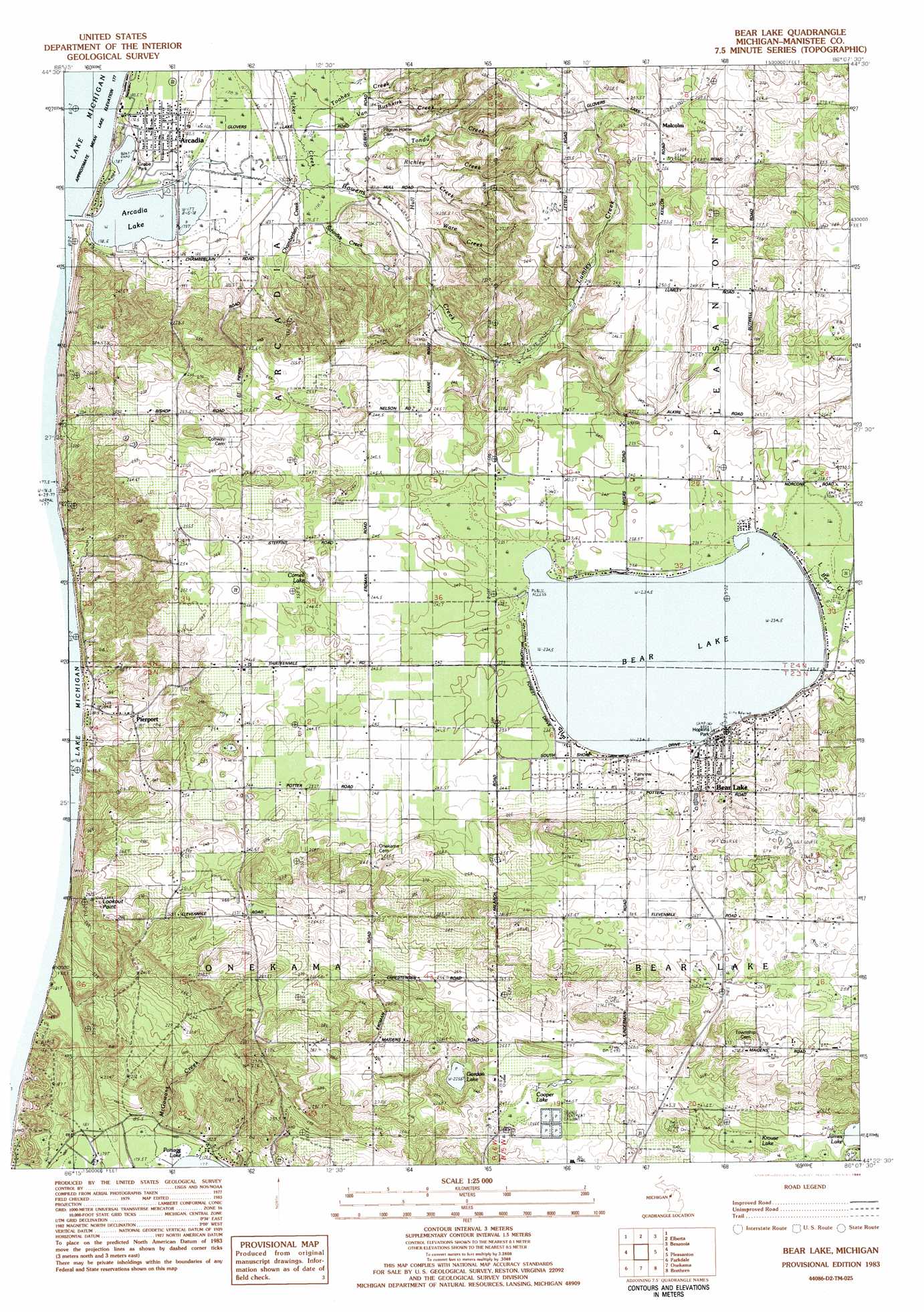
USGS Topo Quad 44086d2 - 1:25,000 scale
| Topo Map Name: | Bear Lake |
| USGS Topo Quad ID: | 44086d2 |
| Print Size: | ca. 21 1/4" wide x 27" high |
| Southeast Coordinates: | 44.375° N latitude / 86.125° W longitude |
| Map Center Coordinates: | 44.4375° N latitude / 86.1875° W longitude |
| U.S. State: | MI |
| Filename: | l44086d2.jpg |
| Download Map JPG Image: | Bear Lake topo map 1:25,000 scale |
| Map Type: | Topographic |
| Topo Series: | 7.5´ |
| Map Scale: | 1:25,000 |
| Source of Map Images: | United States Geological Survey (USGS) |
| Alternate Map Versions: |
1:24,000 Topo Quads surrounding Bear Lake
Frankfort |
Beulah |
Platte River |
||
Elberta |
Benzonia |
Thompsonville |
||
Bear Lake |
Pleasanton |
Copemish |
||
Parkdale |
Onekama |
Brethern |
Marilla |
|
Manistee Nw |
Manistee Ne |
Freesoil Nw |
Freesoil Ne |
Peacock Nw |
> Back to 44086a1 at 1:100,000 scale
> Back to 44086a1 at 1:250,000 scale
> Back to U.S. Topo Maps home
Bear Lake topo map: Gazetteer
Bear Lake: Capes
Lookout Point elevation 294m 964′Bear Lake: Lakes
Arcadia Lake elevation 177m 580′Bear Lake elevation 234m 767′
Cooper Lake elevation 242m 793′
Gordon Lake elevation 225m 738′
Krouse Lake elevation 232m 761′
Bear Lake: Parks
Arcadia Veterans Memorial elevation 180m 590′Grebe Park elevation 177m 580′
Harriet Quimby Childhood Home Historical Marker elevation 245m 803′
Harriet Quimby Historical Marker elevation 245m 803′
Hopkins Park elevation 237m 777′
Pickard Park elevation 182m 597′
Trinity Lutheran Church Historical Marker elevation 183m 600′
Bear Lake: Populated Places
Arcadia elevation 181m 593′Bear Lake elevation 241m 790′
Malcolm elevation 255m 836′
Pierport elevation 193m 633′
Bear Lake: Post Offices
Arcadia Post Office elevation 183m 600′Bear Lake Post Office elevation 243m 797′
Malcolm Post Office (historical) elevation 255m 836′
Pierport Post Office (historical) elevation 193m 633′
Pierport Post Office (historical) elevation 193m 633′
Bear Lake: Streams
Bowens Creek elevation 177m 580′Chamberlain Creek elevation 180m 590′
Hull Creek elevation 184m 603′
Lucker Creek elevation 179m 587′
Lumley Creek elevation 204m 669′
McGowans Creek elevation 177m 580′
Richley Creek elevation 179m 587′
Schimke Creek elevation 179m 587′
Tondu Creek elevation 179m 587′
Toohey Creek elevation 179m 587′
Van Bushkirk Creek elevation 178m 583′
Ware Creek elevation 183m 600′
Bear Lake: Swamps
Cornell Lake elevation 235m 770′Bear Lake digital topo map on disk
Buy this Bear Lake topo map showing relief, roads, GPS coordinates and other geographical features, as a high-resolution digital map file on DVD: