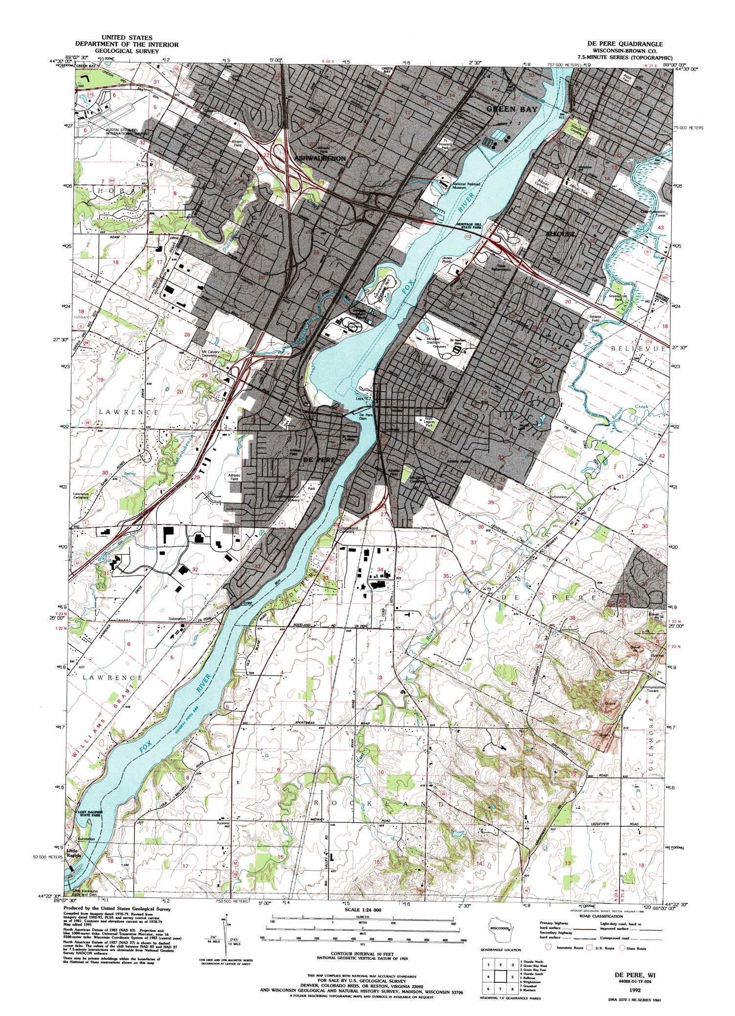
De Pere Topo Map Wisconsin
To zoom in, hover over the map of De Pere
USGS Topo Quad 44088d1 - 1:24,000 scale
| Topo Map Name: | De Pere |
| USGS Topo Quad ID: | 44088d1 |
| Print Size: | ca. 21 1/4" wide x 27" high |
| Southeast Coordinates: | 44.375° N latitude / 88° W longitude |
| Map Center Coordinates: | 44.4375° N latitude / 88.0625° W longitude |
| U.S. State: | WI |
| Filename: | o44088d1.jpg |
| Download Map JPG Image: | De Pere topo map 1:24,000 scale |
| Map Type: | Topographic |
| Topo Series: | 7.5´ |
| Map Scale: | 1:24,000 |
| Source of Map Images: | United States Geological Survey (USGS) |
| Alternate Map Versions: |
De Pere WI 1954, updated 1956 Download PDF Buy paper map De Pere WI 1954, updated 1972 Download PDF Buy paper map De Pere WI 1982, updated 1982 Download PDF Buy paper map De Pere WI 1992, updated 1996 Download PDF Buy paper map De Pere WI 2010 Download PDF Buy paper map De Pere WI 2013 Download PDF Buy paper map De Pere WI 2016 Download PDF Buy paper map |
1:24,000 Topo Quads surrounding De Pere
Zachow |
Pulaski |
Suamico |
Little Tail Point |
Dyckesville |
Seymour |
Oneida North |
Green Bay West |
Green Bay East |
New Franken |
Freedom |
Oneida South |
De Pere |
Bellevue |
Poland |
Kaukauna |
Wrightstown |
Greenleaf |
Morrison |
Denmark |
Sherwood |
Hilbert |
Brillion |
Reedsville |
Whitelaw |
> Back to 44088a1 at 1:100,000 scale
> Back to 44088a1 at 1:250,000 scale
> Back to U.S. Topo Maps home
De Pere topo map: Gazetteer
De Pere: Airports
Foxair Seaplane Base elevation 177m 580′De Pere: Capes
Jones Point elevation 178m 583′De Pere: Crossings
Interchange 161 elevation 188m 616′Interchange 163 elevation 186m 610′
Interchange 164 elevation 186m 610′
Interchange 165 elevation 192m 629′
De Pere: Dams
De Pere Dam elevation 179m 587′Depere Dam elevation 178m 583′
Little Kaukauna Dam elevation 179m 587′
Little Kaukauna Lock and Dam elevation 180m 590′
Pouwels 3lM79802 Dam elevation 213m 698′
De Pere: Parks
Allouez Park elevation 190m 623′Ashwaumobay Memorial Park elevation 184m 603′
Astor Park elevation 187m 613′
Brown County Fair Grounds elevation 184m 603′
Cooke Park elevation 181m 593′
Fort Howard Park elevation 183m 600′
Heritage Hill State Park elevation 188m 616′
Legion Park elevation 190m 623′
Lost Dauphin State Park elevation 193m 633′
Minahan Stadium elevation 184m 603′
Smith Park elevation 192m 629′
Veterans of Foreign Wars Park elevation 188m 616′
De Pere: Populated Places
Allouez elevation 182m 597′Ashwaubenon elevation 185m 606′
De Pere elevation 183m 600′
West De Pere elevation 182m 597′
De Pere: Post Offices
De Pere Post Office elevation 185m 606′De Pere: Reservoirs
1 Reservoir elevation 213m 698′6322 Reservoir elevation 179m 587′
6336 Reservoir elevation 178m 583′
De Pere: Streams
Ashwaubenon Creek elevation 177m 580′Bower Creek elevation 180m 590′
Dutchman Creek elevation 177m 580′
Hemlock Creek elevation 185m 606′
De Pere digital topo map on disk
Buy this De Pere topo map showing relief, roads, GPS coordinates and other geographical features, as a high-resolution digital map file on DVD: