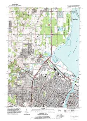
Green Bay West Topo Map Wisconsin
To zoom in, hover over the map of Green Bay West
USGS Topo Quad 44088e1 - 1:24,000 scale
| Topo Map Name: | Green Bay West |
| USGS Topo Quad ID: | 44088e1 |
| Print Size: | ca. 21 1/4" wide x 27" high |
| Southeast Coordinates: | 44.5° N latitude / 88° W longitude |
| Map Center Coordinates: | 44.5625° N latitude / 88.0625° W longitude |
| U.S. State: | WI |
| Filename: | o44088e1.jpg |
| Download Map JPG Image: | Green Bay West topo map 1:24,000 scale |
| Map Type: | Topographic |
| Topo Series: | 7.5´ |
| Map Scale: | 1:24,000 |
| Source of Map Images: | United States Geological Survey (USGS) |
| Alternate Map Versions: |
Green Bay West WI 1954, updated 1956 Download PDF Buy paper map Green Bay West WI 1954, updated 1972 Download PDF Buy paper map Green Bay West WI 1982, updated 1983 Download PDF Buy paper map Green Bay West WI 1992, updated 1996 Download PDF Buy paper map Green Bay West WI 2010 Download PDF Buy paper map Green Bay West WI 2013 Download PDF Buy paper map Green Bay West WI 2016 Download PDF Buy paper map |
1:24,000 Topo Quads surrounding Green Bay West
> Back to 44088e1 at 1:100,000 scale
> Back to 44088a1 at 1:250,000 scale
> Back to U.S. Topo Maps home
Green Bay West topo map: Gazetteer
Green Bay West: Airports
John Antonneau Memorial Airport elevation 179m 587′Plainview Landing Strip elevation 179m 587′
Saint Marys Hospital Heliport elevation 187m 613′
Saint Vincent Hospital Heliport elevation 189m 620′
Green Bay West: Bays
Dead Horse Bay elevation 177m 580′Peats Lake elevation 177m 580′
Green Bay West: Bridges
Leo Frigo Memorial Bridge elevation 177m 580′Tilleman Bridge elevation 177m 580′
Green Bay West: Crossings
Interchange 167 elevation 200m 656′Interchange 168 elevation 195m 639′
Interchange 169 elevation 191m 626′
Interchange 170 elevation 185m 606′
Interchange 171 elevation 185m 606′
Interchange 173 elevation 183m 600′
Interchange 176 elevation 185m 606′
Interchange 189 elevation 180m 590′
Interchange 192 elevation 181m 593′
Green Bay West: Islands
Cat Island elevation 177m 580′Green Bay West: Parks
Admiral Flatley Park elevation 177m 580′Baird Park elevation 187m 613′
Barney Williams Park elevation 179m 587′
Beaver Dam Park elevation 195m 639′
Biemert Park elevation 185m 606′
Canterbury Park elevation 197m 646′
Colburn Park elevation 194m 636′
Fireman Park elevation 196m 643′
Fort Howard Park elevation 180m 590′
Frank B Seymour Park elevation 180m 590′
He-Nis-Ra Park elevation 211m 692′
Hiram Fisk Park elevation 179m 587′
Jackson Park elevation 179m 587′
Lambeau Field elevation 194m 636′
Marquette Park elevation 184m 603′
Mather Heights Park elevation 181m 593′
Muir Park elevation 197m 646′
Murphy Park elevation 186m 610′
Otto Tank Park elevation 179m 587′
Pamperin Park elevation 178m 583′
Perkins Park elevation 184m 603′
Saint James Park elevation 186m 610′
Saint Johns Park elevation 179m 587′
Tower Park elevation 180m 590′
Whitney Park elevation 180m 590′
Green Bay West: Populated Places
Cormier elevation 180m 590′Duck Creek elevation 187m 613′
Elm Tree Corners elevation 194m 636′
Green Bay elevation 180m 590′
Howard elevation 187m 613′
Green Bay West: Post Offices
Green Bay Post Office elevation 180m 590′Green Bay West: Streams
Beaver Dam Creek elevation 179m 587′Duck Creek elevation 177m 580′
East River elevation 177m 580′
Fox River elevation 177m 580′
Green Bay West: Summits
Burdon Hill elevation 237m 777′Platten Hill elevation 219m 718′
Green Bay West: Swamps
Peters Marsh elevation 178m 583′Green Bay West digital topo map on disk
Buy this Green Bay West topo map showing relief, roads, GPS coordinates and other geographical features, as a high-resolution digital map file on DVD:


