Oconto Falls South Topo Map Wisconsin
To zoom in, hover over the map of Oconto Falls South
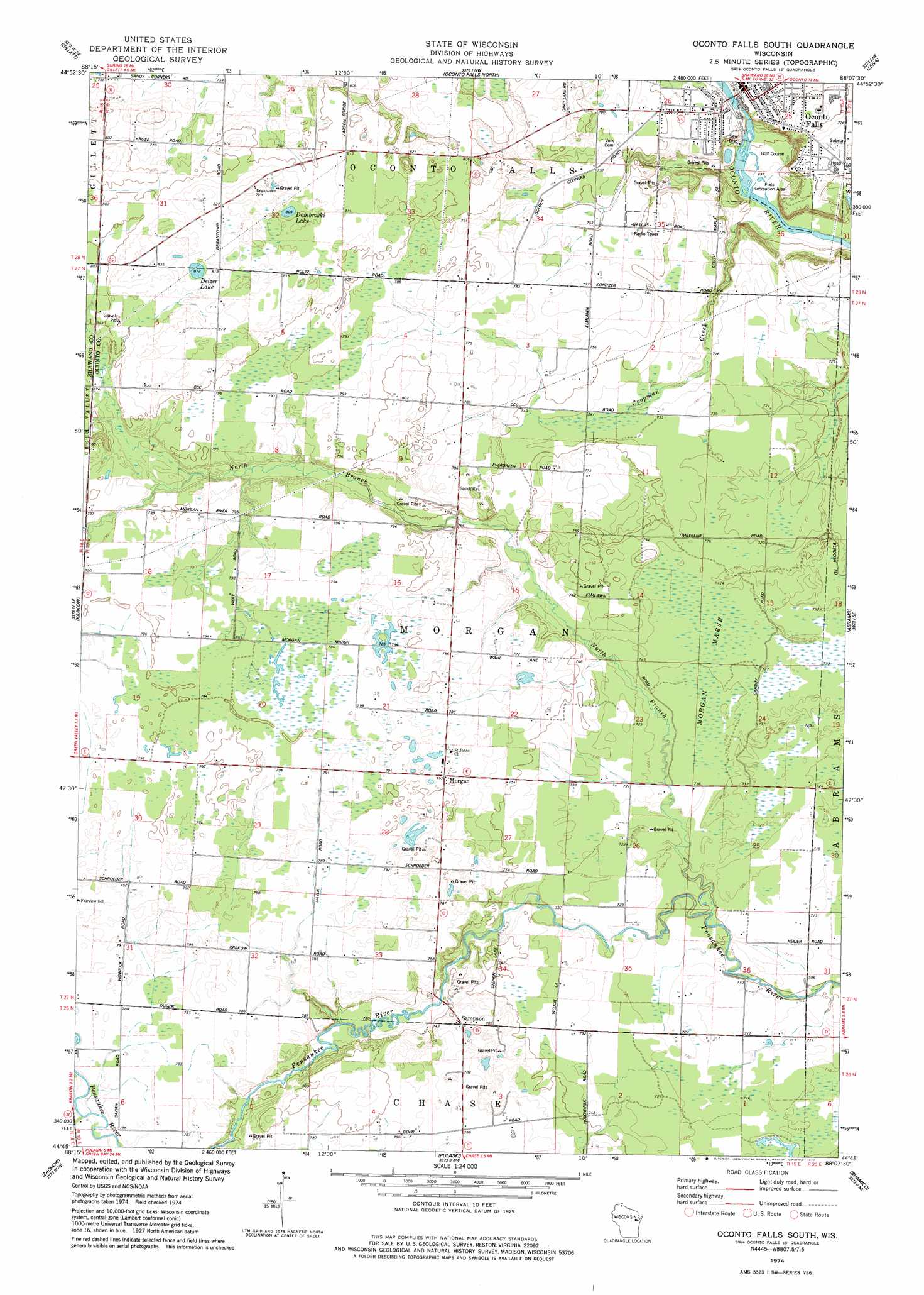
USGS Topo Quad 44088g2 - 1:24,000 scale
| Topo Map Name: | Oconto Falls South |
| USGS Topo Quad ID: | 44088g2 |
| Print Size: | ca. 21 1/4" wide x 27" high |
| Southeast Coordinates: | 44.75° N latitude / 88.125° W longitude |
| Map Center Coordinates: | 44.8125° N latitude / 88.1875° W longitude |
| U.S. State: | WI |
| Filename: | o44088g2.jpg |
| Download Map JPG Image: | Oconto Falls South topo map 1:24,000 scale |
| Map Type: | Topographic |
| Topo Series: | 7.5´ |
| Map Scale: | 1:24,000 |
| Source of Map Images: | United States Geological Survey (USGS) |
| Alternate Map Versions: |
Oconto Falls South WI 1974, updated 1977 Download PDF Buy paper map Oconto Falls South WI 2010 Download PDF Buy paper map Oconto Falls South WI 2013 Download PDF Buy paper map Oconto Falls South WI 2016 Download PDF Buy paper map |
1:24,000 Topo Quads surrounding Oconto Falls South
Breed |
Hickory Corners |
Kelly Lake |
Coleman |
Porterfiled Sw |
Berry Lake |
Gillett |
Oconto Falls North |
Lena |
Oconto West |
Cecil |
Krakow |
Oconto Falls South |
Abrams |
Pensaukee |
Bonduel |
Zachow |
Pulaski |
Suamico |
Little Tail Point |
Nichols |
Seymour |
Oneida North |
Green Bay West |
Green Bay East |
> Back to 44088e1 at 1:100,000 scale
> Back to 44088a1 at 1:250,000 scale
> Back to U.S. Topo Maps home
Oconto Falls South topo map: Gazetteer
Oconto Falls South: Airports
Community Memorial Hospital Heliport elevation 219m 718′Oconto Falls South: Dams
Lower Oconto Falls 1857c195 Dam elevation 212m 695′Oconto Falls South: Lakes
Delzer Lake elevation 249m 816′Dombroski Lake elevation 247m 810′
Oconto Falls South: Parks
Flats Recreation Area elevation 194m 636′Oconto Falls South: Populated Places
Morgan elevation 241m 790′Oconto Falls elevation 226m 741′
Sampson elevation 240m 787′
Oconto Falls South: Post Offices
Oconto Falls Post Office elevation 226m 741′Oconto Falls South: Reservoirs
731 Reservoir elevation 212m 695′Oconto Falls South: Streams
Coopman Creek elevation 194m 636′North Branch Pensaukee River elevation 212m 695′
Oconto Falls South: Swamps
Morgan Marsh elevation 219m 718′Oconto Falls South digital topo map on disk
Buy this Oconto Falls South topo map showing relief, roads, GPS coordinates and other geographical features, as a high-resolution digital map file on DVD: