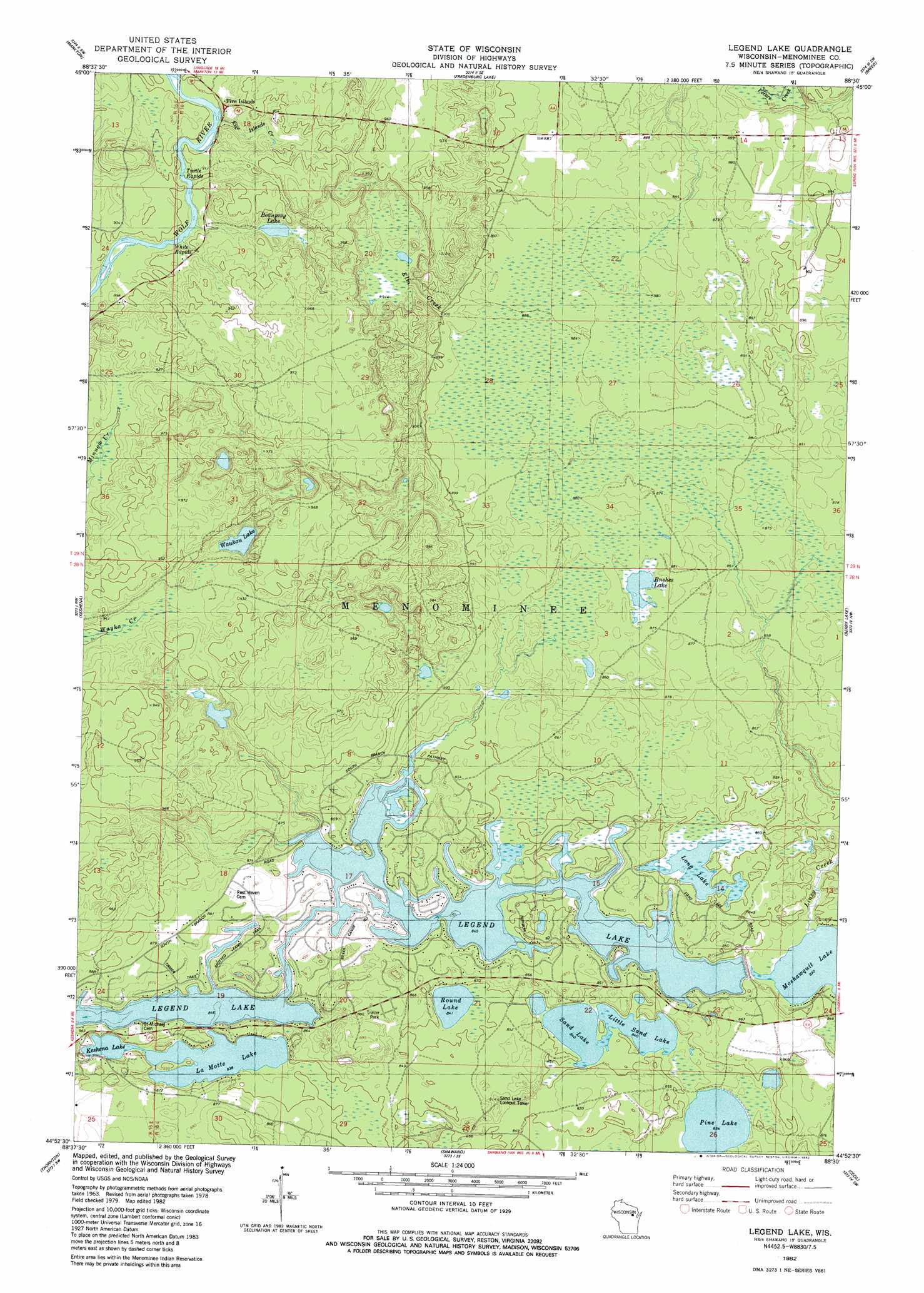
Legend Lake Topo Map Wisconsin
To zoom in, hover over the map of Legend Lake
USGS Topo Quad 44088h5 - 1:24,000 scale
| Topo Map Name: | Legend Lake |
| USGS Topo Quad ID: | 44088h5 |
| Print Size: | ca. 21 1/4" wide x 27" high |
| Southeast Coordinates: | 44.875° N latitude / 88.5° W longitude |
| Map Center Coordinates: | 44.9375° N latitude / 88.5625° W longitude |
| U.S. State: | WI |
| Filename: | o44088h5.jpg |
| Download Map JPG Image: | Legend Lake topo map 1:24,000 scale |
| Map Type: | Topographic |
| Topo Series: | 7.5´ |
| Map Scale: | 1:24,000 |
| Source of Map Images: | United States Geological Survey (USGS) |
| Alternate Map Versions: |
Legend Lake WI 1982, updated 1982 Download PDF Buy paper map Legend Lake WI 2010 Download PDF Buy paper map Legend Lake WI 2013 Download PDF Buy paper map Legend Lake WI 2016 Download PDF Buy paper map |
1:24,000 Topo Quads surrounding Legend Lake
White Lake |
Langlade |
Shadow Lake |
Mountain |
Shay Lake |
Perote Lake |
Markton |
Fredenberg Lake |
Breed |
Hickory Corners |
Neopit |
Keshena |
Legend Lake |
Berry Lake |
Gillett |
Gresham |
Thornton |
Shawano |
Cecil |
Krakow |
Clintonville North |
Embarrass |
Lunds |
Bonduel |
Zachow |
> Back to 44088e1 at 1:100,000 scale
> Back to 44088a1 at 1:250,000 scale
> Back to U.S. Topo Maps home
Legend Lake topo map: Gazetteer
Legend Lake: Dams
Legend Lake Number Three 3 WR 543 Dam elevation 258m 846′Legend Lake: Islands
Five Islands elevation 273m 895′Legend Lake: Lakes
Beauprey Lake elevation 279m 915′Blacksmith Lake elevation 258m 846′
Keshena Lake elevation 255m 836′
La Motte Lake elevation 255m 836′
Legend Lake elevation 259m 849′
Little Blacksmith Lake elevation 258m 846′
Little Sand Lake elevation 256m 839′
Long Lake elevation 258m 846′
Pestiga Lake elevation 258m 846′
Pine Lake elevation 254m 833′
Pywaosit Lake elevation 258m 846′
Round Lake elevation 256m 839′
Rushes Lake elevation 263m 862′
Sand Lake elevation 256m 839′
Sapokesick Lake elevation 258m 846′
Skice Lake elevation 258m 846′
Spring Lake elevation 258m 846′
Waukau Lake elevation 278m 912′
Legend Lake: Populated Places
Legend Lake elevation 268m 879′Legend Lake: Rapids
Turtle Rapids elevation 271m 889′White Rapids elevation 271m 889′
Legend Lake: Streams
Elm Creek elevation 271m 889′Five Island Creek elevation 272m 892′
Legend Lake digital topo map on disk
Buy this Legend Lake topo map showing relief, roads, GPS coordinates and other geographical features, as a high-resolution digital map file on DVD: