Ettrick Topo Map Wisconsin
To zoom in, hover over the map of Ettrick
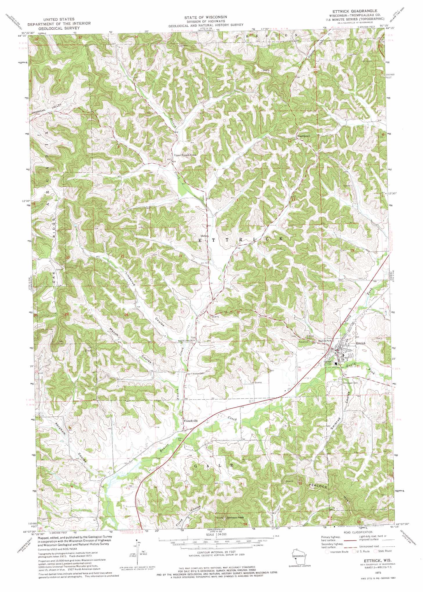
USGS Topo Quad 44091b3 - 1:24,000 scale
| Topo Map Name: | Ettrick |
| USGS Topo Quad ID: | 44091b3 |
| Print Size: | ca. 21 1/4" wide x 27" high |
| Southeast Coordinates: | 44.125° N latitude / 91.25° W longitude |
| Map Center Coordinates: | 44.1875° N latitude / 91.3125° W longitude |
| U.S. State: | WI |
| Filename: | o44091b3.jpg |
| Download Map JPG Image: | Ettrick topo map 1:24,000 scale |
| Map Type: | Topographic |
| Topo Series: | 7.5´ |
| Map Scale: | 1:24,000 |
| Source of Map Images: | United States Geological Survey (USGS) |
| Alternate Map Versions: |
Ettrick WI 1973, updated 1975 Download PDF Buy paper map Ettrick WI 2010 Download PDF Buy paper map Ettrick WI 2013 Download PDF Buy paper map Ettrick WI 2015 Download PDF Buy paper map |
1:24,000 Topo Quads surrounding Ettrick
Lookout |
Elk Creek |
Pleasantville |
Pigeon Falls |
Hixton |
Swinns Valley |
Independence |
Whitehall |
Blair |
Taylor |
Dodge |
Tamarack |
Ettrick |
Hegg |
North Bend Ne |
Winona East |
Trempealeau |
Galesville |
Stevenstown |
North Bend |
Witoka |
Pickwick |
Holmen |
Onalaska |
West Salem |
> Back to 44091a1 at 1:100,000 scale
> Back to 44090a1 at 1:250,000 scale
> Back to U.S. Topo Maps home
Ettrick topo map: Gazetteer
Ettrick: Populated Places
Chapultepee elevation 320m 1049′Ettrick elevation 235m 770′
Frenchville elevation 226m 741′
Iduna elevation 241m 790′
Upper French Creek elevation 251m 823′
Ettrick: Streams
French Creek elevation 225m 738′North Fork Beaver Creek elevation 231m 757′
South Fork Beaver Creek elevation 231m 757′
Ettrick: Summits
Johnson Peak elevation 377m 1236′Ettrick: Valleys
Abraham Coulee elevation 224m 734′Linderund Coulee elevation 235m 770′
Mason Coulee elevation 234m 767′
Smikrud Coulee elevation 236m 774′
Ettrick digital topo map on disk
Buy this Ettrick topo map showing relief, roads, GPS coordinates and other geographical features, as a high-resolution digital map file on DVD: