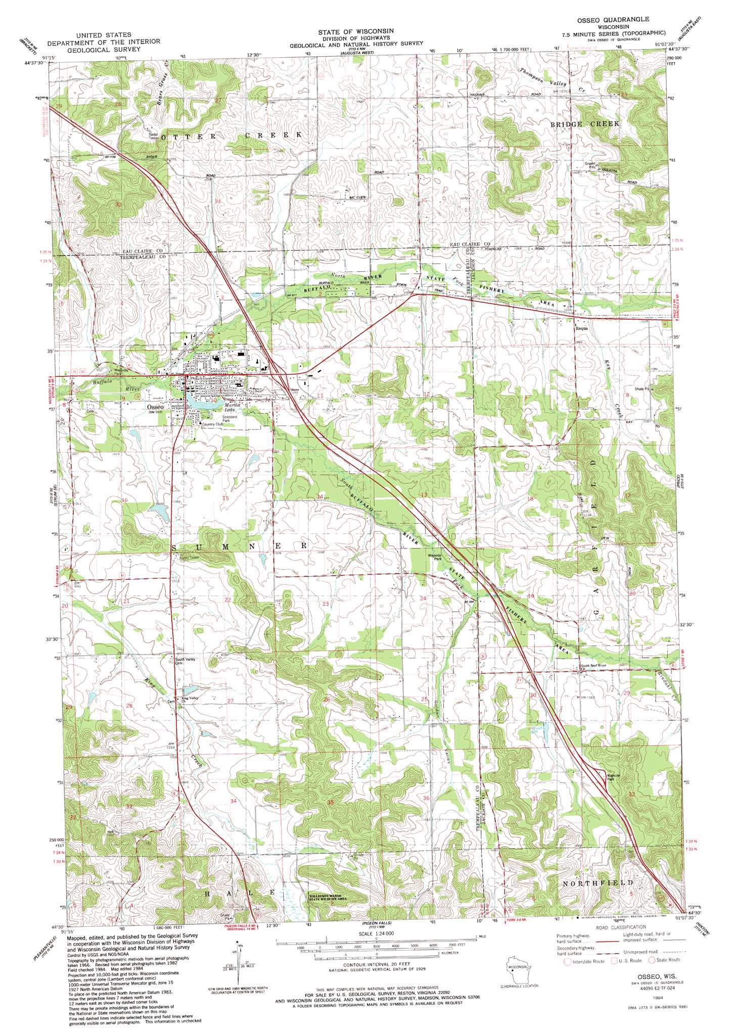
Osseo Topo Map Wisconsin
To zoom in, hover over the map of Osseo
USGS Topo Quad 44091e2 - 1:24,000 scale
| Topo Map Name: | Osseo |
| USGS Topo Quad ID: | 44091e2 |
| Print Size: | ca. 21 1/4" wide x 27" high |
| Southeast Coordinates: | 44.5° N latitude / 91.125° W longitude |
| Map Center Coordinates: | 44.5625° N latitude / 91.1875° W longitude |
| U.S. State: | WI |
| Filename: | o44091e2.jpg |
| Download Map JPG Image: | Osseo topo map 1:24,000 scale |
| Map Type: | Topographic |
| Topo Series: | 7.5´ |
| Map Scale: | 1:24,000 |
| Source of Map Images: | United States Geological Survey (USGS) |
| Alternate Map Versions: |
Osseo WI 1984, updated 1984 Download PDF Buy paper map Osseo WI 2010 Download PDF Buy paper map Osseo WI 2013 Download PDF Buy paper map Osseo WI 2015 Download PDF Buy paper map |
1:24,000 Topo Quads surrounding Osseo
Eau Claire East |
Fall Creek |
Lake Eau Claire West |
Lake Eau Claire East |
Simes Creek |
Cleghorn |
Brackett |
Augusta West |
Augusta East |
Horse Creek |
Strum |
Strum Se |
Osseo |
Price |
Fairchild |
Elk Creek |
Pleasantville |
Pigeon Falls |
Hixton |
Alma Center |
Independence |
Whitehall |
Blair |
Taylor |
Stenulson Coulee |
> Back to 44091e1 at 1:100,000 scale
> Back to 44090a1 at 1:250,000 scale
> Back to U.S. Topo Maps home
Osseo topo map: Gazetteer
Osseo: Dams
Johnson H1199 Dam elevation 313m 1026′Osseo Dam elevation 290m 951′
Osseo Rod and Gun Club Dam elevation 299m 980′
Skoyen G-9503 Dam elevation 305m 1000′
Osseo: Parks
Stoddard Park elevation 293m 961′Osseo: Populated Places
Osseo elevation 292m 958′Requa elevation 311m 1020′
Osseo: Reservoirs
0.3 Reservoir elevation 313m 1026′0.47 Reservoir elevation 305m 1000′
Martha Lake elevation 290m 951′
Martha Lake 34 elevation 290m 951′
Osseo Club Pond elevation 299m 980′
Osseo: Streams
Kay Creek elevation 307m 1007′North Fork Buffalo River elevation 289m 948′
Rindahl Creek elevation 311m 1020′
South Fork Buffalo River elevation 289m 948′
Osseo: Valleys
Golden Valley elevation 305m 1000′Osseo digital topo map on disk
Buy this Osseo topo map showing relief, roads, GPS coordinates and other geographical features, as a high-resolution digital map file on DVD: