Durand North Topo Map Wisconsin
To zoom in, hover over the map of Durand North
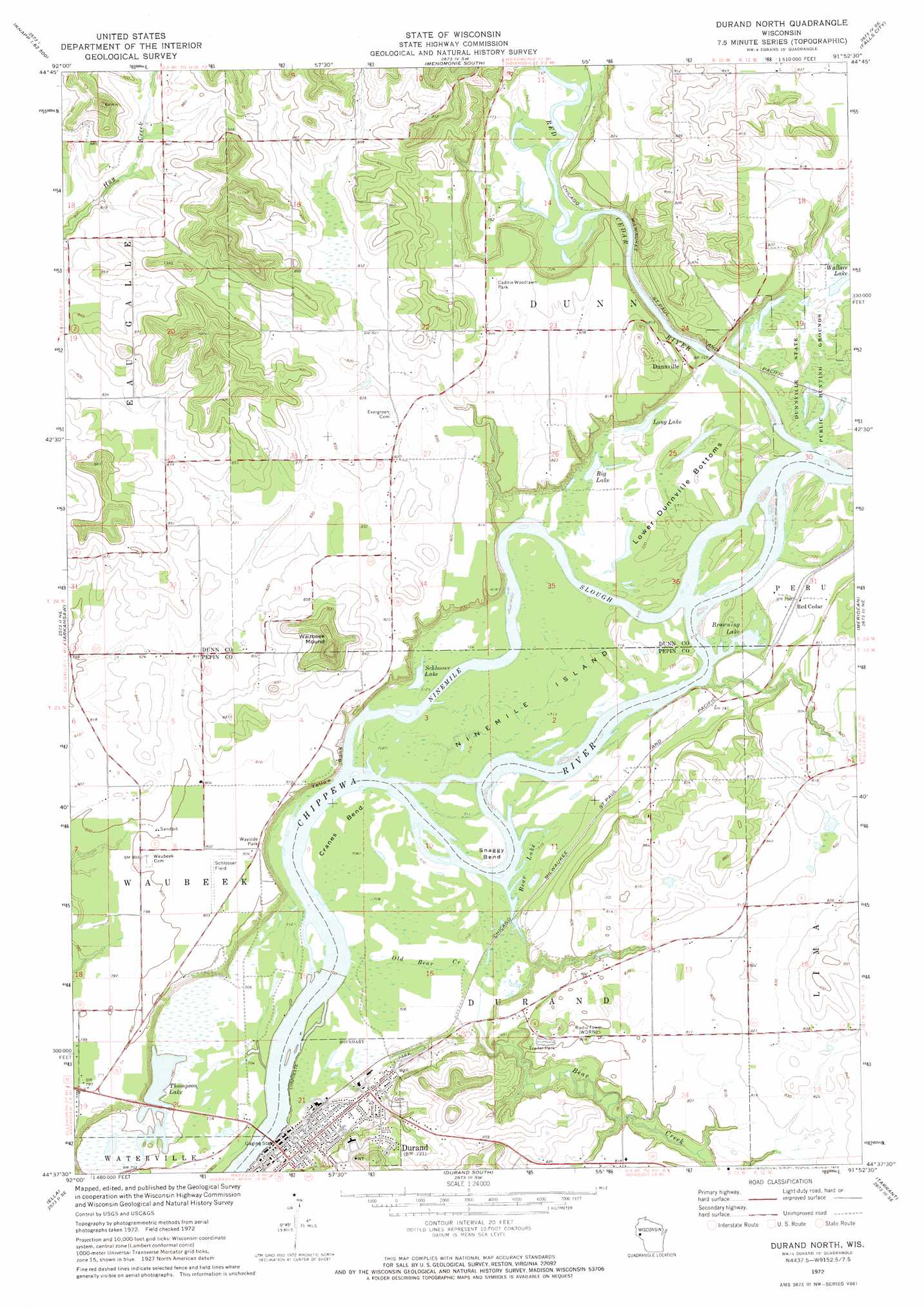
USGS Topo Quad 44091f8 - 1:24,000 scale
| Topo Map Name: | Durand North |
| USGS Topo Quad ID: | 44091f8 |
| Print Size: | ca. 21 1/4" wide x 27" high |
| Southeast Coordinates: | 44.625° N latitude / 91.875° W longitude |
| Map Center Coordinates: | 44.6875° N latitude / 91.9375° W longitude |
| U.S. State: | WI |
| Filename: | o44091f8.jpg |
| Download Map JPG Image: | Durand North topo map 1:24,000 scale |
| Map Type: | Topographic |
| Topo Series: | 7.5´ |
| Map Scale: | 1:24,000 |
| Source of Map Images: | United States Geological Survey (USGS) |
| Alternate Map Versions: |
Durand North WI 1972, updated 1975 Download PDF Buy paper map Durand North WI 2010 Download PDF Buy paper map Durand North WI 2013 Download PDF Buy paper map Durand North WI 2015 Download PDF Buy paper map |
1:24,000 Topo Quads surrounding Durand North
Wilson |
Knapp |
Menomonie North |
Rusk |
Colfax South |
Spring Valley |
Weston |
Menomonie South |
Falls City |
Elk Creek Lake |
Plum City |
Arkansaw |
Durand North |
Meridean |
Rock Falls |
Nerike Hill |
Ella |
Durand South |
Tarrant |
Mondovi |
Pepin |
Wabasha North |
Urne |
Modena |
Gilmanton |
> Back to 44091e1 at 1:100,000 scale
> Back to 44090a1 at 1:250,000 scale
> Back to U.S. Topo Maps home
Durand North topo map: Gazetteer
Durand North: Airports
Schlosser Field elevation 245m 803′Durand North: Bays
Bear Lake elevation 213m 698′Browning Lake elevation 213m 698′
Durand North: Bends
Cranes Bend elevation 216m 708′Lower Dunnville Bottoms elevation 219m 718′
Snaggy Bend elevation 215m 705′
Durand North: Cliffs
Yellow Bank elevation 213m 698′Durand North: Islands
Ninemile Island elevation 215m 705′Durand North: Lakes
Big Lake elevation 216m 708′Long Lake elevation 217m 711′
Schlosser Lake elevation 216m 708′
Thompson Lake elevation 210m 688′
Wallace Lake elevation 216m 708′
Durand North: Parks
Caddie Woodlawn Park elevation 252m 826′Nine Mile Island State Natural Area elevation 216m 708′
Durand North: Populated Places
Dunnville elevation 249m 816′Durand elevation 228m 748′
Red Cedar elevation 231m 757′
Durand North: Streams
Bear Creek elevation 215m 705′Ninemile Slough elevation 213m 698′
Old Bear Creek elevation 214m 702′
Red Cedar River elevation 216m 708′
Durand North: Summits
Waubeek Mound elevation 350m 1148′Durand North digital topo map on disk
Buy this Durand North topo map showing relief, roads, GPS coordinates and other geographical features, as a high-resolution digital map file on DVD: