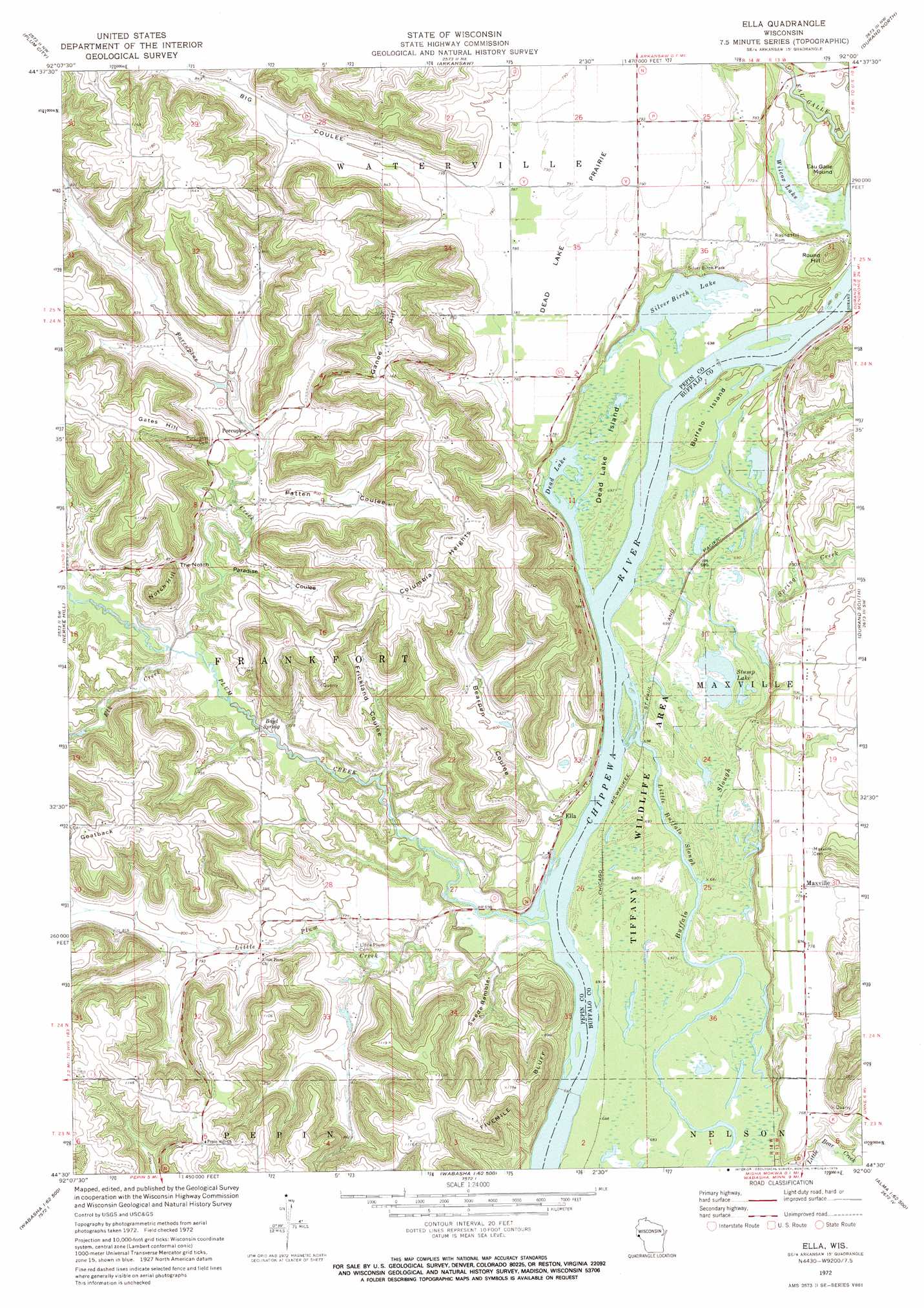
Ella Topo Map Wisconsin
To zoom in, hover over the map of Ella
USGS Topo Quad 44092e1 - 1:24,000 scale
| Topo Map Name: | Ella |
| USGS Topo Quad ID: | 44092e1 |
| Print Size: | ca. 21 1/4" wide x 27" high |
| Southeast Coordinates: | 44.5° N latitude / 92° W longitude |
| Map Center Coordinates: | 44.5625° N latitude / 92.0625° W longitude |
| U.S. State: | WI |
| Filename: | o44092e1.jpg |
| Download Map JPG Image: | Ella topo map 1:24,000 scale |
| Map Type: | Topographic |
| Topo Series: | 7.5´ |
| Map Scale: | 1:24,000 |
| Source of Map Images: | United States Geological Survey (USGS) |
| Alternate Map Versions: |
Ella WI 1972, updated 1975 Download PDF Buy paper map Ella WI 2010 Download PDF Buy paper map Ella WI 2013 Download PDF Buy paper map Ella WI 2015 Download PDF Buy paper map |
1:24,000 Topo Quads surrounding Ella
El Paso |
Spring Valley |
Weston |
Menomonie South |
Falls City |
Waverly |
Plum City |
Arkansaw |
Durand North |
Meridean |
Maiden Rock |
Nerike Hill |
Ella |
Durand South |
Tarrant |
Lake City |
Pepin |
Wabasha North |
Urne |
Modena |
West Albany |
Theilman |
Wabasha South |
Alma |
Cream |
> Back to 44092e1 at 1:100,000 scale
> Back to 44092a1 at 1:250,000 scale
> Back to U.S. Topo Maps home
Ella topo map: Gazetteer
Ella: Airports
Durand Municipal Airport elevation 233m 764′Rutherford Airport elevation 241m 790′
Ella: Areas
Maxville Prairie elevation 235m 770′Ella: Dams
Kallstrom Mercer Group Dam elevation 245m 803′Plum Creek 12 E-4499 Dam elevation 238m 780′
Ella: Flats
Dead Lake Prairie elevation 240m 787′Ella: Gaps
The Notch elevation 263m 862′Ella: Islands
Buffalo Island elevation 213m 698′Dead Lake Island elevation 214m 702′
Ella: Lakes
Dead Lake elevation 207m 679′Silver Birch Lake elevation 210m 688′
Stump Lake elevation 210m 688′
Wilcox Lake elevation 210m 688′
Ella: Parks
Silver Birch Park elevation 215m 705′Tiffany Bottoms State Natural Area elevation 212m 695′
Ella: Populated Places
Ella elevation 218m 715′Maxville elevation 235m 770′
Porcupine elevation 237m 777′
Savoy (historical) elevation 212m 695′
Ella: Reservoirs
2 Reservoir elevation 238m 780′Ella: Ridges
Columbia Heights elevation 355m 1164′Goatback elevation 359m 1177′
Ella: Springs
Boyd Spring elevation 217m 711′Ella: Streams
Elk Creek elevation 218m 715′Little Buffalo Slough elevation 212m 695′
Little Plum Creek elevation 207m 679′
Plum Creek elevation 207m 679′
Porcupine Creek elevation 215m 705′
Spring Creek elevation 213m 698′
Ella: Summits
Eau Galle Mound elevation 241m 790′Ganoe Hill elevation 350m 1148′
Gates Hill elevation 345m 1131′
Notch Hill elevation 321m 1053′
Round Hill elevation 297m 974′
Ella: Valleys
Bearpen Coulee elevation 217m 711′Big Coulee elevation 242m 793′
Frickland Coulee elevation 214m 702′
Paradise Coulee elevation 215m 705′
Patten Coulee elevation 232m 761′
Swede Ramble elevation 216m 708′
Ella digital topo map on disk
Buy this Ella topo map showing relief, roads, GPS coordinates and other geographical features, as a high-resolution digital map file on DVD: