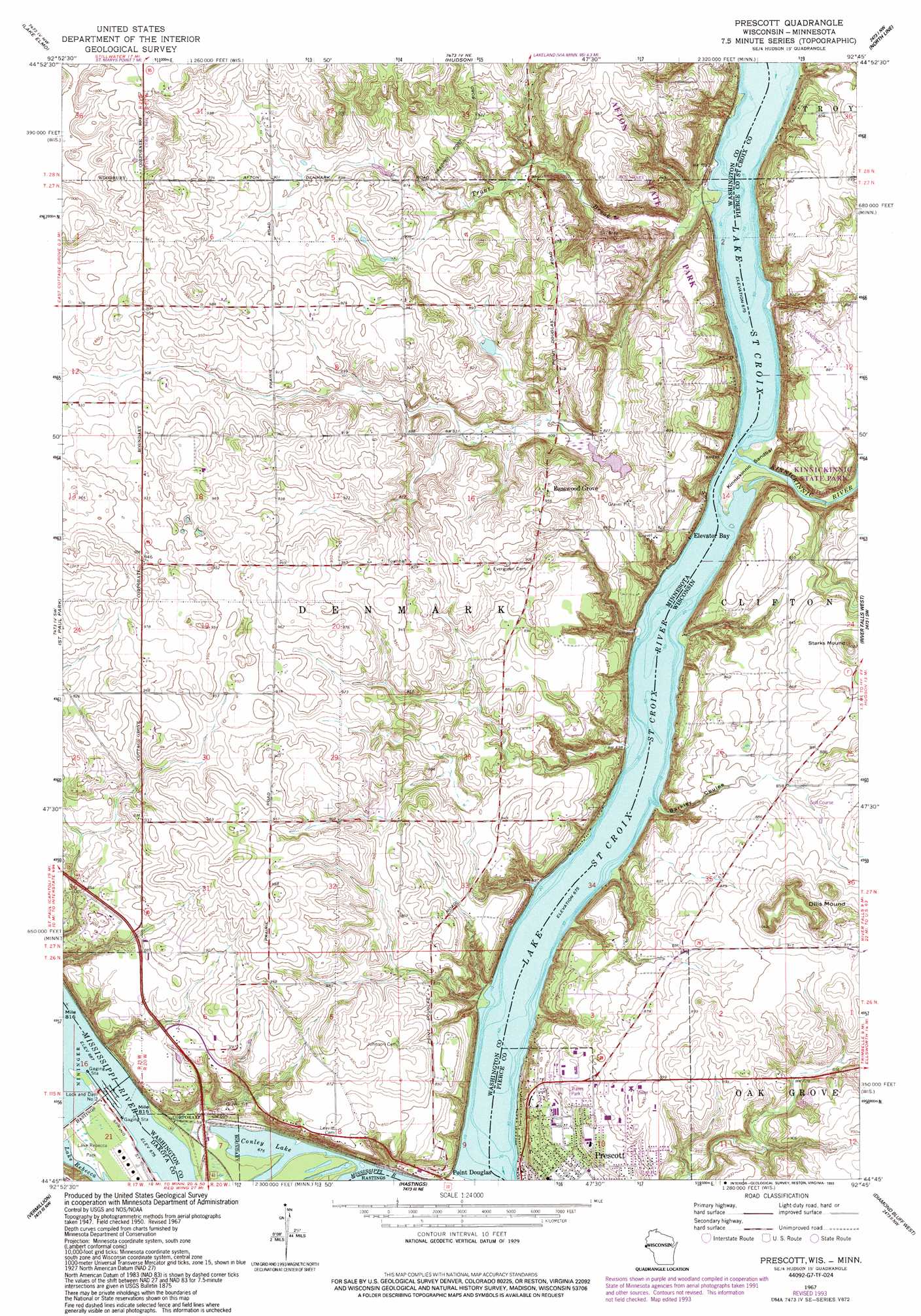
Prescott Topo Map Minnesota
To zoom in, hover over the map of Prescott
USGS Topo Quad 44092g7 - 1:24,000 scale
| Topo Map Name: | Prescott |
| USGS Topo Quad ID: | 44092g7 |
| Print Size: | ca. 21 1/4" wide x 27" high |
| Southeast Coordinates: | 44.75° N latitude / 92.75° W longitude |
| Map Center Coordinates: | 44.8125° N latitude / 92.8125° W longitude |
| U.S. States: | MN, WI |
| Filename: | o44092g7.jpg |
| Download Map JPG Image: | Prescott topo map 1:24,000 scale |
| Map Type: | Topographic |
| Topo Series: | 7.5´ |
| Map Scale: | 1:24,000 |
| Source of Map Images: | United States Geological Survey (USGS) |
| Alternate Map Versions: |
Prescott WI 1951 Download PDF Buy paper map Prescott WI 1951 Download PDF Buy paper map Prescott WI 1951, updated 1961 Download PDF Buy paper map Prescott WI 1967, updated 1969 Download PDF Buy paper map Prescott WI 1967, updated 1976 Download PDF Buy paper map Prescott WI 1967, updated 1989 Download PDF Buy paper map Prescott WI 1967, updated 1993 Download PDF Buy paper map Prescott WI 2010 Download PDF Buy paper map Prescott WI 2013 Download PDF Buy paper map Prescott WI 2015 Download PDF Buy paper map |
1:24,000 Topo Quads surrounding Prescott
White Bear Lake West |
White Bear Lake East |
Stillwater |
Somerset South |
New Richmond South |
Saint Paul East |
Lake Elmo |
Hudson |
Northline |
Roberts |
Inver Grove Heights |
Saint Paul Park |
Prescott |
River Falls West |
River Falls East |
Coates |
Vermillion |
Hastings |
Diamond Bluff West |
Diamond Bluff East |
Randolph |
Cannon Falls |
Miesville |
Welch |
Red Wing |
> Back to 44092e1 at 1:100,000 scale
> Back to 44092a1 at 1:250,000 scale
> Back to U.S. Topo Maps home
Prescott topo map: Gazetteer
Prescott: Airports
Saint Croix Riviera Airport elevation 269m 882′Prescott: Bars
Kinnickinnic Sandbar elevation 207m 679′Prescott: Dams
Couwette Group Pond Dam elevation 248m 813′Lock and Dam Number Two elevation 207m 679′
Locks and Dam Number 2 elevation 208m 682′
Schuester Pond Dam elevation 260m 853′
Prescott: Lakes
Conley Lake elevation 206m 675′Prescott: Levees
Afton Alps Golf Course elevation 287m 941′Prescott: Parks
Afton State Park elevation 286m 938′Andrea Park elevation 247m 810′
Kinnickinnic River Gorge and Delta State Natural Area elevation 208m 682′
Lake Rebecca Park elevation 208m 682′
Prescott: Populated Places
Basswood Grove elevation 292m 958′Point Douglas elevation 220m 721′
Prescott: Post Offices
Point Douglas Post Office (historical) elevation 221m 725′Prescott: Reservoirs
Pool 2 elevation 208m 682′Prescott: Streams
Kinnickinnic River elevation 206m 675′Trout Brook elevation 206m 675′
Prescott: Summits
Dills Mound elevation 320m 1049′Starks Mound elevation 310m 1017′
Prescott: Valleys
Barkley Coulee elevation 206m 675′Clifton Hollow elevation 211m 692′
Prescott digital topo map on disk
Buy this Prescott topo map showing relief, roads, GPS coordinates and other geographical features, as a high-resolution digital map file on DVD: