Jordan West Topo Map Minnesota
To zoom in, hover over the map of Jordan West
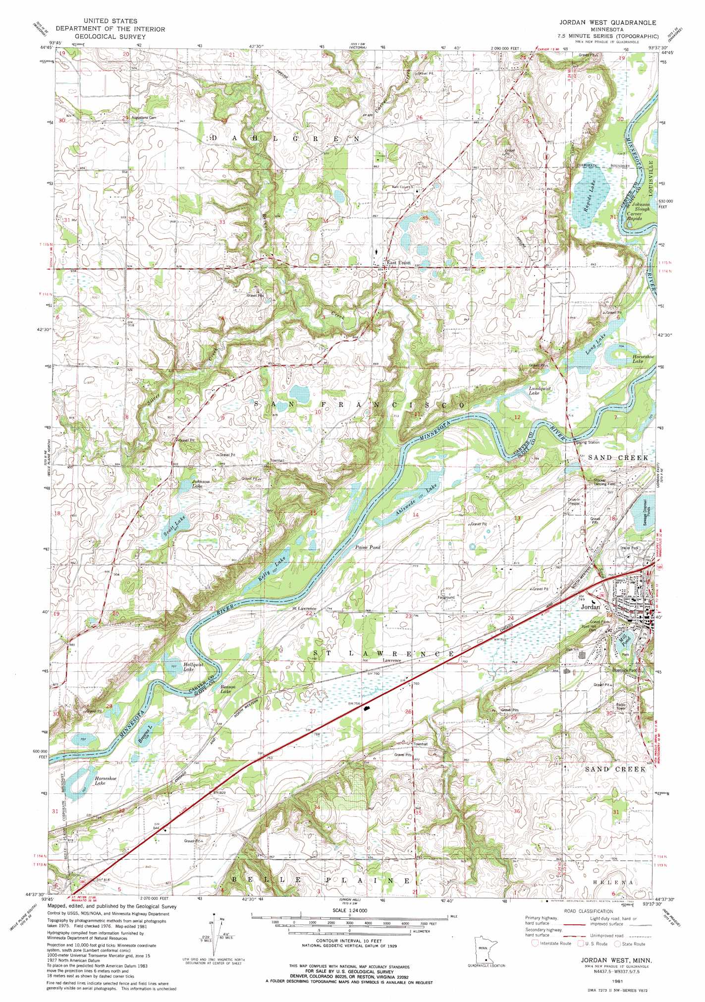
USGS Topo Quad 44093f6 - 1:24,000 scale
| Topo Map Name: | Jordan West |
| USGS Topo Quad ID: | 44093f6 |
| Print Size: | ca. 21 1/4" wide x 27" high |
| Southeast Coordinates: | 44.625° N latitude / 93.625° W longitude |
| Map Center Coordinates: | 44.6875° N latitude / 93.6875° W longitude |
| U.S. State: | MN |
| Filename: | o44093f6.jpg |
| Download Map JPG Image: | Jordan West topo map 1:24,000 scale |
| Map Type: | Topographic |
| Topo Series: | 7.5´ |
| Map Scale: | 1:24,000 |
| Source of Map Images: | United States Geological Survey (USGS) |
| Alternate Map Versions: |
Jordan West MN 1981, updated 1982 Download PDF Buy paper map Jordan West MN 2010 Download PDF Buy paper map Jordan West MN 2013 Download PDF Buy paper map Jordan West MN 2016 Download PDF Buy paper map |
1:24,000 Topo Quads surrounding Jordan West
Mayer |
Watertown |
Mound |
Excelsior |
Hopkins |
Norwood |
Waconia |
Victoria |
Shakopee |
Eden Prairie |
Hamburg |
Belle Plaine North |
Jordan West |
Jordan East |
Prior Lake |
Henderson |
Belle Plaine South |
Union Hill |
New Prague |
Veseli |
Le Sueur |
Saint Thomas |
Le Center |
Montgomery |
Lonsdale |
> Back to 44093e1 at 1:100,000 scale
> Back to 44092a1 at 1:250,000 scale
> Back to U.S. Topo Maps home
Jordan West topo map: Gazetteer
Jordan West: Airports
Stocker Landing Field elevation 250m 820′Jordan West: Dams
Ruehlings Pond Dam elevation 258m 846′Sand Creek Dam elevation 236m 774′
Jordan West: Guts
Johnson Slough elevation 215m 705′Jordan West: Lakes
Ahlswede Lake elevation 215m 705′Beason Lake elevation 215m 705′
Browns Lake elevation 215m 705′
Hallquist Lake elevation 215m 705′
Horseshoe Lake elevation 215m 705′
Horseshoe Lake elevation 215m 705′
Johnson Lake elevation 268m 879′
Kelly Lake elevation 215m 705′
Long Lake elevation 215m 705′
Lundquist Lake elevation 216m 708′
Mill Pond elevation 236m 774′
Paine Pond elevation 216m 708′
Rapids Lake elevation 215m 705′
Scott Lake elevation 267m 875′
Jordan West: Parks
Brentwood Park elevation 231m 757′Holzer Park elevation 226m 741′
Jordan Wayside Park elevation 240m 787′
Lagoon Park elevation 238m 780′
Lagoon Park elevation 237m 777′
Pekarna Park elevation 234m 767′
Riesgraf-Lions Park elevation 228m 748′
Timberline Park elevation 246m 807′
Jordan West: Populated Places
East Union elevation 261m 856′Jordan elevation 235m 770′
Lawrence elevation 232m 761′
Valley Green Mobile Home Park elevation 227m 744′
Jordan West: Post Offices
East Union Post Office (historical) elevation 261m 856′Jordan Post Office elevation 236m 774′
Saint Lawrence Post Office (historical) elevation 226m 741′
Jordan West: Rapids
Carver Rapids elevation 213m 698′Jordan West: Reservoirs
Ruehlings Pond elevation 258m 846′Sand Creek Reservoir elevation 236m 774′
Jordan West: Streams
Bevens Creek elevation 216m 708′Silver Creek elevation 239m 784′
Jordan West digital topo map on disk
Buy this Jordan West topo map showing relief, roads, GPS coordinates and other geographical features, as a high-resolution digital map file on DVD: