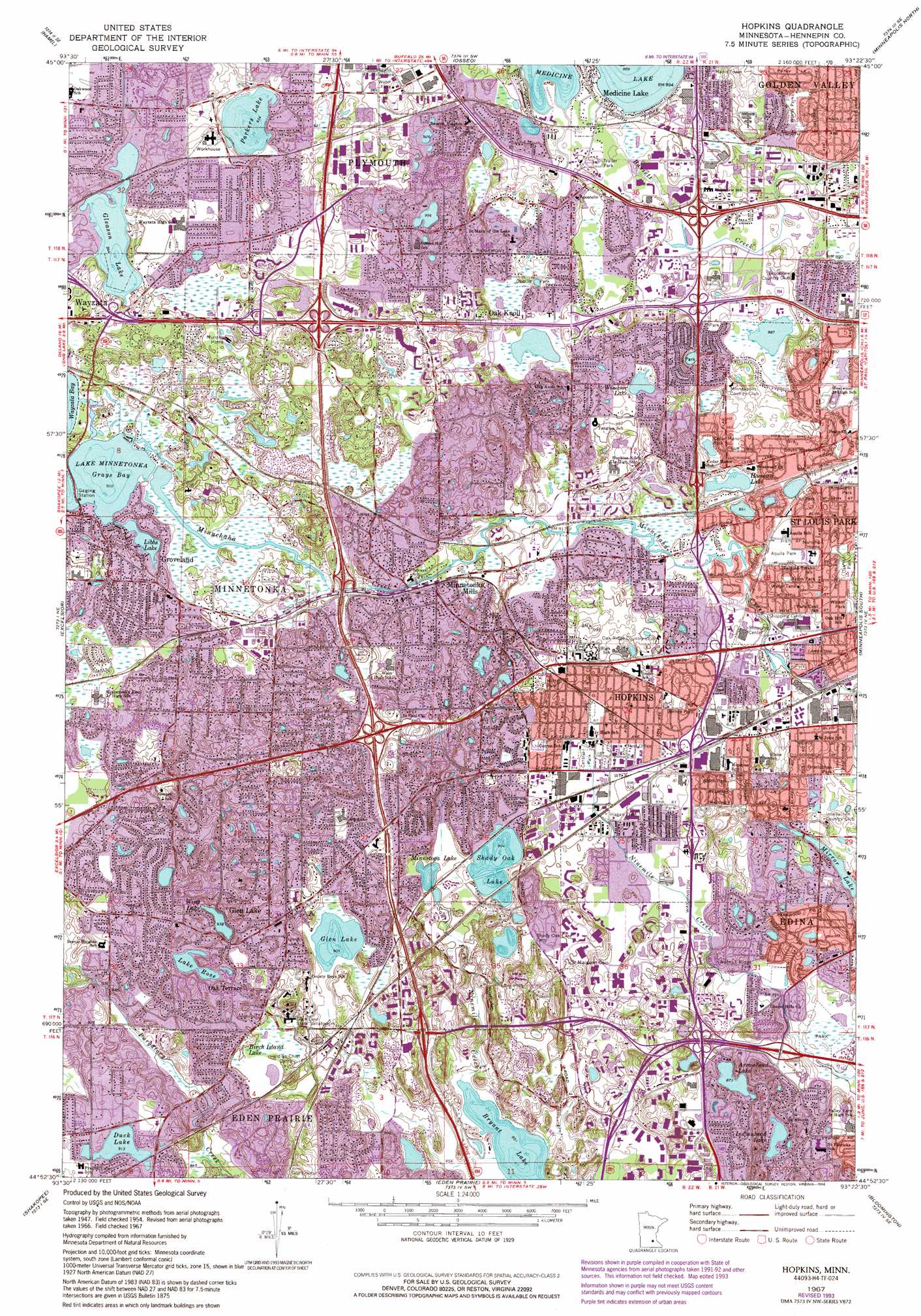
Hopkins Topo Map Minnesota
To zoom in, hover over the map of Hopkins
USGS Topo Quad 44093h4 - 1:24,000 scale
| Topo Map Name: | Hopkins |
| USGS Topo Quad ID: | 44093h4 |
| Print Size: | ca. 21 1/4" wide x 27" high |
| Southeast Coordinates: | 44.875° N latitude / 93.375° W longitude |
| Map Center Coordinates: | 44.9375° N latitude / 93.4375° W longitude |
| U.S. State: | MN |
| Filename: | o44093h4.jpg |
| Download Map JPG Image: | Hopkins topo map 1:24,000 scale |
| Map Type: | Topographic |
| Topo Series: | 7.5´ |
| Map Scale: | 1:24,000 |
| Source of Map Images: | United States Geological Survey (USGS) |
| Alternate Map Versions: |
Hopkins MN 1954, updated 1956 Download PDF Buy paper map Hopkins MN 1954, updated 1964 Download PDF Buy paper map Hopkins MN 1967, updated 1969 Download PDF Buy paper map Hopkins MN 1967, updated 1981 Download PDF Buy paper map Hopkins MN 1967, updated 1987 Download PDF Buy paper map Hopkins MN 1967, updated 1994 Download PDF Buy paper map Hopkins MN 2010 Download PDF Buy paper map Hopkins MN 2013 Download PDF Buy paper map Hopkins MN 2016 Download PDF Buy paper map |
1:24,000 Topo Quads surrounding Hopkins
Saint Michael |
Rogers |
Anoka |
Coon Rapids |
Circle Pines |
Rockford |
Hamel |
Osseo |
Minneapolis North |
New Brighton |
Mound |
Excelsior |
Hopkins |
Minneapolis South |
Saint Paul West |
Victoria |
Shakopee |
Eden Prairie |
Bloomington |
Saint Paul Sw |
Jordan West |
Jordan East |
Prior Lake |
Orchard Lake |
Farmington |
> Back to 44093e1 at 1:100,000 scale
> Back to 44092a1 at 1:250,000 scale
> Back to U.S. Topo Maps home
Hopkins topo map: Gazetteer
Hopkins: Airports
Bryant Lake Seaplane Base elevation 261m 856′Eastmans Medicine Lake Seaplane Base elevation 272m 892′
Hopkins Police Heliport elevation 275m 902′
Peterson Seaplane Base elevation 276m 905′
Hopkins: Bays
Grays Bay elevation 285m 935′Hopkins: Bridges
Grays Bay Bridge elevation 285m 935′Libbs Lake Bridge elevation 286m 938′
Hopkins: Crossings
Interchange 13 elevation 291m 954′Interchange 16A and 16B elevation 302m 990′
Interchange 17 elevation 287m 941′
Interchange 19A elevation 294m 964′
Interchange 19B elevation 294m 964′
Interchange 1A elevation 302m 990′
Interchange 1B elevation 293m 961′
Interchange 1C elevation 288m 944′
Interchange 2 elevation 282m 925′
Interchange 20 elevation 296m 971′
Interchange 21 elevation 288m 944′
Interchange 3 elevation 282m 925′
Hopkins: Lakes
Arrowhead Lake elevation 266m 872′Birch Island Lake elevation 273m 895′
Bryant Lake elevation 260m 853′
Cavanaugh Lake elevation 305m 1000′
Crane Lake elevation 279m 915′
Duck Lake elevation 280m 918′
Gleason Lake elevation 288m 944′
Glen Lake elevation 276m 905′
Hannan Lake elevation 273m 895′
Hidden Lake elevation 273m 895′
Indianhead Lake elevation 267m 875′
Lake Holiday elevation 289m 948′
Lake Holiday elevation 285m 935′
Lake Rose elevation 282m 925′
Libbs Lake elevation 285m 935′
Lone Lake elevation 276m 905′
Minnetoga Lake elevation 273m 895′
Mirror Lake elevation 276m 905′
Parkers Lake elevation 285m 935′
Shady Oak Lake elevation 276m 905′
Spring Lake elevation 293m 961′
Victoria Lake elevation 273m 895′
Windsor Lake elevation 286m 938′
Wing Lake elevation 286m 938′
Hopkins: Parks
Ainsworth Park elevation 277m 908′Alden Park elevation 290m 951′
Aquila Park elevation 282m 925′
Birch Island Park elevation 274m 898′
Birchview Elementary Park elevation 288m 944′
Bredesen Park elevation 261m 856′
Brookview Park elevation 271m 889′
Bryant Lake Regional Park elevation 280m 918′
Burnes Park elevation 284m 931′
Cedar Manor Park elevation 273m 895′
Central Park elevation 277m 908′
Circle Park elevation 299m 980′
Creek Valley School Park elevation 279m 915′
Ford Park elevation 280m 918′
Forest Hills School Park elevation 266m 872′
Fox Meadow Park elevation 285m 935′
Gleanloch Park elevation 301m 987′
Golden Oaks Park elevation 281m 921′
Hagan Field elevation 273m 895′
Hilltop Park elevation 286m 938′
Interlachen Park elevation 274m 898′
LaCompte Green Community Playfield elevation 274m 898′
Lakeview Heights Park elevation 273m 895′
Medicine Lake Park elevation 272m 892′
Oak Hill Park elevation 281m 921′
Oakwood Community Playground elevation 300m 984′
Oberlin Park elevation 280m 918′
Parkers Lake Community Playfield elevation 293m 961′
Parkers Lake Park elevation 286m 938′
Prairie View School Park elevation 283m 928′
Rainbow Park elevation 284m 931′
Ridgemount Community Playfield elevation 277m 908′
Rustic Hills Park elevation 284m 931′
Saint Mary's Park elevation 278m 912′
Shelard Park elevation 272m 892′
South Westwood Hills Park elevation 271m 889′
Sunset Hills Elementary Park elevation 300m 984′
Texa-Tonka Park elevation 274m 898′
Van Valkenburg Park elevation 293m 961′
Walker Park elevation 281m 921′
Walnut Ridge Park elevation 264m 866′
Wesley Park elevation 273m 895′
Xylon Park elevation 276m 905′
Hopkins: Populated Places
Glen Lake elevation 287m 941′Groveland elevation 294m 964′
Hopkins elevation 314m 1030′
Medicine Lake elevation 274m 898′
Minnetonka Mills elevation 288m 944′
Oak Knoll elevation 280m 918′
Oak Terrace elevation 287m 941′
Hopkins: Post Offices
Glen Lake Post Office (historical) elevation 286m 938′Hopkins Post Office elevation 282m 925′
Medicine Lake Post Office (historical) elevation 274m 898′
Minnetonka Post Office elevation 290m 951′
Oak Terrace Post Office (historical) elevation 289m 948′
Parkers Lake Post Office (historical) elevation 301m 987′
Hopkins digital topo map on disk
Buy this Hopkins topo map showing relief, roads, GPS coordinates and other geographical features, as a high-resolution digital map file on DVD: