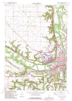
Mankato West Topo Map Minnesota
To zoom in, hover over the map of Mankato West
USGS Topo Quad 44094b1 - 1:24,000 scale
| Topo Map Name: | Mankato West |
| USGS Topo Quad ID: | 44094b1 |
| Print Size: | ca. 21 1/4" wide x 27" high |
| Southeast Coordinates: | 44.125° N latitude / 94° W longitude |
| Map Center Coordinates: | 44.1875° N latitude / 94.0625° W longitude |
| U.S. State: | MN |
| Filename: | o44094b1.jpg |
| Download Map JPG Image: | Mankato West topo map 1:24,000 scale |
| Map Type: | Topographic |
| Topo Series: | 7.5´ |
| Map Scale: | 1:24,000 |
| Source of Map Images: | United States Geological Survey (USGS) |
| Alternate Map Versions: |
Mankato West MN 1974, updated 1976 Download PDF Buy paper map Mankato West MN 1974, updated 1993 Download PDF Buy paper map Mankato West MN 2010 Download PDF Buy paper map Mankato West MN 2013 Download PDF Buy paper map Mankato West MN 2016 Download PDF Buy paper map |
1:24,000 Topo Quads surrounding Mankato West
> Back to 44094a1 at 1:100,000 scale
> Back to 44094a1 at 1:250,000 scale
> Back to U.S. Topo Maps home
Mankato West topo map: Gazetteer
Mankato West: Airports
Budde Airport elevation 302m 990′Mankato West: Bridges
Northstar Bridge elevation 230m 754′Veterans Memorial Bridge elevation 230m 754′
Mankato West: Canals
County Ditch Number Three elevation 302m 990′County Ditch Number Twelve elevation 300m 984′
Mankato West: Falls
Minnemishinona Falls elevation 252m 826′Minnewankon Falls elevation 258m 846′
Mankato West: Lakes
Hiniker Pond elevation 231m 757′Mankato West: Parks
Bluff Park elevation 302m 990′Carney Park elevation 254m 833′
Caswell Park elevation 305m 1000′
East Sibley Park elevation 239m 784′
Forest Heights Park elevation 301m 987′
Hiniker Pond Park elevation 231m 757′
King Arthur Park elevation 305m 1000′
Land of Memories Park elevation 237m 777′
Mankato Region Historical Marker elevation 302m 990′
Minneopa State Park elevation 260m 853′
North Ridge Park elevation 302m 990′
Rasmussen Park elevation 238m 780′
Riverview Park elevation 231m 757′
Seppman Mill Historical Marker elevation 260m 853′
Sibley Park elevation 239m 784′
Skyline Park elevation 300m 984′
Spring Lake Park elevation 232m 761′
Stoltzman Park elevation 236m 774′
Wallyn Park elevation 235m 770′
Walter S Farm Park elevation 305m 1000′
Webster Fields elevation 232m 761′
West Mankato Park elevation 257m 843′
West Sibley Park elevation 247m 810′
Wheeler Park elevation 232m 761′
Mankato West: Populated Places
Avalon elevation 304m 997′Camelot Park elevation 305m 1000′
Kerns elevation 302m 990′
LeHillier elevation 240m 787′
North Mankato elevation 305m 1000′
Riverbend Estates elevation 267m 875′
Skyline elevation 300m 984′
Mankato West: Post Offices
Kerns Post Office (historical) elevation 302m 990′Mankato Post Office elevation 241m 790′
Mankato West: Reservoirs
Troost Pond elevation 236m 774′Mankato West: Streams
Blue Earth River elevation 231m 757′Le Sueur River elevation 234m 767′
Minneopa Creek elevation 231m 757′
Mankato West digital topo map on disk
Buy this Mankato West topo map showing relief, roads, GPS coordinates and other geographical features, as a high-resolution digital map file on DVD:


