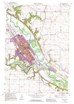
New Ulm Topo Map Minnesota
To zoom in, hover over the map of New Ulm
USGS Topo Quad 44094c4 - 1:24,000 scale
| Topo Map Name: | New Ulm |
| USGS Topo Quad ID: | 44094c4 |
| Print Size: | ca. 21 1/4" wide x 27" high |
| Southeast Coordinates: | 44.25° N latitude / 94.375° W longitude |
| Map Center Coordinates: | 44.3125° N latitude / 94.4375° W longitude |
| U.S. State: | MN |
| Filename: | o44094c4.jpg |
| Download Map JPG Image: | New Ulm topo map 1:24,000 scale |
| Map Type: | Topographic |
| Topo Series: | 7.5´ |
| Map Scale: | 1:24,000 |
| Source of Map Images: | United States Geological Survey (USGS) |
| Alternate Map Versions: |
New Ulm MN 1964, updated 1965 Download PDF Buy paper map New Ulm MN 1964, updated 1978 Download PDF Buy paper map New Ulm MN 1992, updated 1995 Download PDF Buy paper map New Ulm MN 2010 Download PDF Buy paper map New Ulm MN 2013 Download PDF Buy paper map New Ulm MN 2016 Download PDF Buy paper map |
1:24,000 Topo Quads surrounding New Ulm
> Back to 44094a1 at 1:100,000 scale
> Back to 44094a1 at 1:250,000 scale
> Back to U.S. Topo Maps home
New Ulm topo map: Gazetteer
New Ulm: Airports
Sioux Valley Hospital Heliport elevation 270m 885′New Ulm: Canals
County Ditch Number Eightyone elevation 299m 980′New Ulm: Parks
Brown County Veterans Memorial elevation 296m 971′Charles Eugene Flandrau Historical Marker elevation 254m 833′
Defenders' State Monument elevation 281m 921′
First School Historical Marker elevation 272m 892′
First White Child Historical Marker elevation 261m 856′
Flandrau State Park elevation 261m 856′
Frank Steele Steamboat Landing Historical Marker elevation 243m 797′
German - Bohemian Monument elevation 262m 859′
Harman Park elevation 265m 869′
Hermann Heights Park elevation 298m 977′
Highland Park elevation 302m 990′
Indian Massacre Monument elevation 279m 915′
Johnson Field elevation 266m 872′
Johnson Park elevation 261m 856′
Junior Pioneer Marker elevation 274m 898′
Kielsing Park elevation 272m 892′
Lincoln Park elevation 283m 928′
Minnecon Park elevation 248m 813′
Nagel Monument elevation 279m 915′
Nehls Park elevation 302m 990′
New Ulm Spring Roadside Parking Area Historical Marker elevation 260m 853′
New Ulm Spring Wayside Park elevation 260m 853′
North German Park elevation 268m 879′
North Market Park elevation 269m 882′
North Park elevation 266m 872′
Pioneer Memorial Marker elevation 279m 915′
Riverside Park elevation 240m 787′
Schonlau Park elevation 271m 889′
Skate Park elevation 264m 866′
South German Park elevation 257m 843′
South Park elevation 262m 859′
Spanish American War Historical Marker elevation 273m 895′
Steinhauser Park elevation 265m 869′
Washington Park elevation 275m 902′
West Park elevation 264m 866′
New Ulm: Populated Places
Klossner elevation 309m 1013′New Ulm elevation 274m 898′
New Ulm Mobile Village elevation 254m 833′
Traulich Estates elevation 262m 859′
New Ulm: Post Offices
Klossner Post Office elevation 309m 1013′New Ulm Post Office elevation 256m 839′
New Ulm: Reservoirs
Lake Cottonwood elevation 247m 810′New Ulm: Streams
Cottonwood River elevation 240m 787′Fritsche Creek elevation 239m 784′
Heymans Creek elevation 239m 784′
Huelskamp Creek elevation 240m 787′
New Ulm digital topo map on disk
Buy this New Ulm topo map showing relief, roads, GPS coordinates and other geographical features, as a high-resolution digital map file on DVD:


