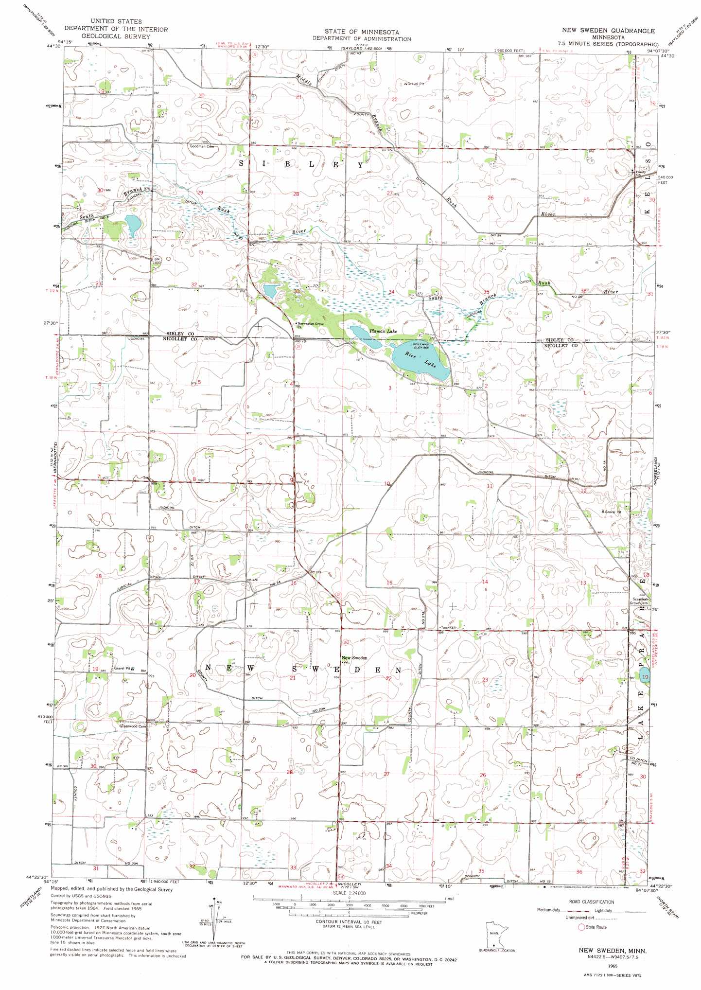
New Sweden Topo Map Minnesota
To zoom in, hover over the map of New Sweden
USGS Topo Quad 44094d2 - 1:24,000 scale
| Topo Map Name: | New Sweden |
| USGS Topo Quad ID: | 44094d2 |
| Print Size: | ca. 21 1/4" wide x 27" high |
| Southeast Coordinates: | 44.375° N latitude / 94.125° W longitude |
| Map Center Coordinates: | 44.4375° N latitude / 94.1875° W longitude |
| U.S. State: | MN |
| Filename: | o44094d2.jpg |
| Download Map JPG Image: | New Sweden topo map 1:24,000 scale |
| Map Type: | Topographic |
| Topo Series: | 7.5´ |
| Map Scale: | 1:24,000 |
| Source of Map Images: | United States Geological Survey (USGS) |
| Alternate Map Versions: |
New Sweden MN 1965, updated 1966 Download PDF Buy paper map New Sweden MN 2010 Download PDF Buy paper map New Sweden MN 2013 Download PDF Buy paper map New Sweden MN 2016 Download PDF Buy paper map |
1:24,000 Topo Quads surrounding New Sweden
Stewart |
Brownton |
New Auburn |
Green Isle |
Hamburg |
Winthrop Sw |
Winthrop |
Gaylord |
Arlington |
Henderson |
Lafayette |
Bernadotte |
New Sweden |
Norseland |
Le Sueur |
New Ulm |
Courtland |
Nicollet |
North Star |
Saint Peter |
Hanska |
Cambria |
Judson |
Mankato West |
Mankato East |
> Back to 44094a1 at 1:100,000 scale
> Back to 44094a1 at 1:250,000 scale
> Back to U.S. Topo Maps home
New Sweden topo map: Gazetteer
New Sweden: Canals
County Ditch Number Fiftyfour elevation 292m 958′County Ditch Number Twentyseven A elevation 299m 980′
County Ditch Number Twentythree A elevation 296m 971′
Judicial Ditch Number Fifteen elevation 296m 971′
Judicial Ditch Number One A elevation 295m 967′
Judicial Ditch Number Twelve elevation 299m 980′
Judicial Ditch Number Twenty elevation 296m 971′
New Sweden: Lakes
Plaman Lake elevation 295m 967′New Sweden: Parks
Norwegian Grove Wayside Park elevation 299m 980′New Sweden: Populated Places
New Sweden elevation 304m 997′New Sweden: Post Offices
New Sweden Post Office (historical) elevation 304m 997′New Sweden: Reservoirs
Rice Lake elevation 296m 971′New Sweden digital topo map on disk
Buy this New Sweden topo map showing relief, roads, GPS coordinates and other geographical features, as a high-resolution digital map file on DVD: