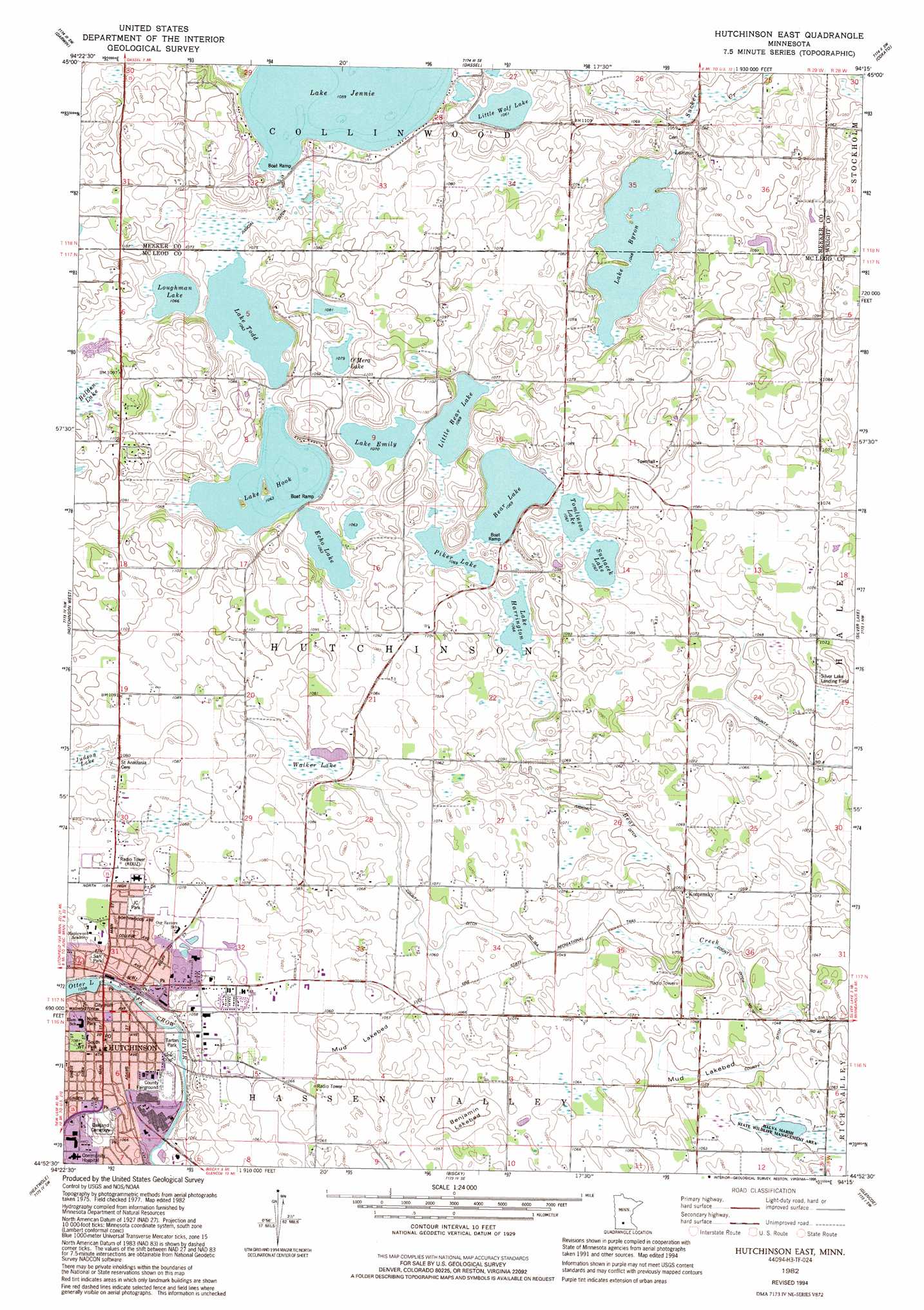
Hutchinson East Topo Map Minnesota
To zoom in, hover over the map of Hutchinson East
USGS Topo Quad 44094h3 - 1:24,000 scale
| Topo Map Name: | Hutchinson East |
| USGS Topo Quad ID: | 44094h3 |
| Print Size: | ca. 21 1/4" wide x 27" high |
| Southeast Coordinates: | 44.875° N latitude / 94.25° W longitude |
| Map Center Coordinates: | 44.9375° N latitude / 94.3125° W longitude |
| U.S. State: | MN |
| Filename: | o44094h3.jpg |
| Download Map JPG Image: | Hutchinson East topo map 1:24,000 scale |
| Map Type: | Topographic |
| Topo Series: | 7.5´ |
| Map Scale: | 1:24,000 |
| Source of Map Images: | United States Geological Survey (USGS) |
| Alternate Map Versions: |
Hutchinson East MN 1982, updated 1982 Download PDF Buy paper map Hutchinson East MN 1982, updated 1995 Download PDF Buy paper map Hutchinson East MN 2010 Download PDF Buy paper map Hutchinson East MN 2013 Download PDF Buy paper map Hutchinson East MN 2016 Download PDF Buy paper map |
1:24,000 Topo Quads surrounding Hutchinson East
Litchfield North |
Forest City |
Kingston |
French Lake |
Albion Center |
Litchfield South |
Darwin |
Dassel |
Cokato |
Howard Lake |
Cedar Mills |
Hutchinson West |
Hutchinson East |
Silver Lake |
Winsted |
Lake Allie |
Heatwole |
Biscay |
Glenco |
Plato |
Buffalo Lake |
Stewart |
Brownton |
New Auburn |
Green Isle |
> Back to 44094e1 at 1:100,000 scale
> Back to 44094a1 at 1:250,000 scale
> Back to U.S. Topo Maps home
Hutchinson East topo map: Gazetteer
Hutchinson East: Airports
Silver Lake Landing Field elevation 319m 1046′Hutchinson East: Canals
County Ditch Number Sixteen elevation 316m 1036′County Ditch Number Sixteen A elevation 323m 1059′
Judicial Ditch Number Nine elevation 319m 1046′
Judicial Ditch Number Thirteen elevation 328m 1076′
Hutchinson East: Dams
Hutchinson Dam elevation 315m 1033′Hutchinson East: Flats
Benjamin Lakebed elevation 319m 1046′Mud Lakebed elevation 319m 1046′
Mud Lakebed elevation 323m 1059′
Hutchinson East: Lakes
Bear Lake elevation 326m 1069′Echo Lake elevation 324m 1062′
Lake Byron elevation 320m 1049′
Lake Emily elevation 326m 1069′
Lake Harrington elevation 325m 1066′
Lake Hook elevation 324m 1062′
Lake Jennie elevation 323m 1059′
Lake Todd elevation 324m 1062′
Little Bear Lake elevation 326m 1069′
Little Wolf Lake elevation 324m 1062′
Loughman Lake elevation 325m 1066′
O'Mera Lake elevation 329m 1079′
Piker Lake elevation 326m 1069′
Sustacek Lake elevation 325m 1066′
Tomlinson Lake elevation 325m 1066′
Hutchinson East: Parks
Boy Scout Park elevation 325m 1066′Crow River Recreational Area elevation 321m 1053′
Eheim Park elevation 316m 1036′
Fireman's Park elevation 314m 1030′
Girl Scout Park elevation 314m 1030′
Halva Marsh State Wildlife Management Area elevation 323m 1059′
Hutchinson Stockade Historical Marker elevation 318m 1043′
Kimberly Park elevation 326m 1069′
Legion Park elevation 326m 1069′
Lions Park East elevation 327m 1072′
McLeod County Veterans Memorial Park elevation 317m 1040′
North Park elevation 319m 1046′
North Woods Park elevation 329m 1079′
Old Bass Pond Park elevation 317m 1040′
Sarr Park elevation 323m 1059′
South Park elevation 330m 1082′
Tartan Park elevation 314m 1030′
VFW Park elevation 326m 1069′
Hutchinson East: Populated Places
Hutchinson elevation 323m 1059′Komensky elevation 323m 1059′
Lamson elevation 331m 1085′
Hutchinson East: Post Offices
Hutchinson Post Office elevation 321m 1053′Hutchinson Post Office elevation 321m 1053′
Lamson Post Office (historical) elevation 332m 1089′
Lamson Post Office (historical) elevation 332m 1089′
Hutchinson East: Reservoirs
Otter Lake elevation 315m 1033′Hutchinson East: Swamps
Belden Lake elevation 327m 1072′Walker Lake elevation 324m 1062′
Hutchinson East digital topo map on disk
Buy this Hutchinson East topo map showing relief, roads, GPS coordinates and other geographical features, as a high-resolution digital map file on DVD: