Hutchinson West Topo Map Minnesota
To zoom in, hover over the map of Hutchinson West
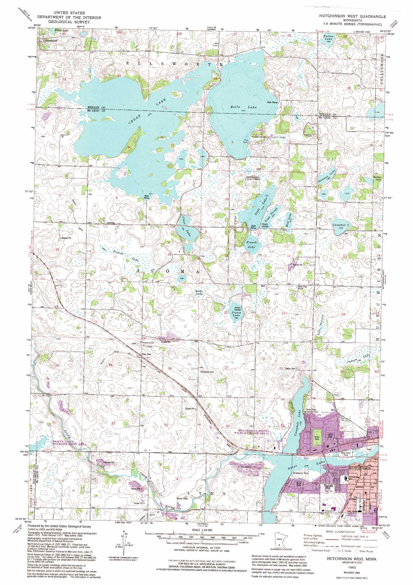
USGS Topo Quad 44094h4 - 1:24,000 scale
| Topo Map Name: | Hutchinson West |
| USGS Topo Quad ID: | 44094h4 |
| Print Size: | ca. 21 1/4" wide x 27" high |
| Southeast Coordinates: | 44.875° N latitude / 94.375° W longitude |
| Map Center Coordinates: | 44.9375° N latitude / 94.4375° W longitude |
| U.S. State: | MN |
| Filename: | o44094h4.jpg |
| Download Map JPG Image: | Hutchinson West topo map 1:24,000 scale |
| Map Type: | Topographic |
| Topo Series: | 7.5´ |
| Map Scale: | 1:24,000 |
| Source of Map Images: | United States Geological Survey (USGS) |
| Alternate Map Versions: |
Hutchinson West MN 1982, updated 1982 Download PDF Buy paper map Hutchinson West MN 1982, updated 1995 Download PDF Buy paper map Hutchinson West MN 2010 Download PDF Buy paper map Hutchinson West MN 2013 Download PDF Buy paper map Hutchinson West MN 2016 Download PDF Buy paper map |
1:24,000 Topo Quads surrounding Hutchinson West
Grove City |
Litchfield North |
Forest City |
Kingston |
French Lake |
Rosendale |
Litchfield South |
Darwin |
Dassel |
Cokato |
Cosmos |
Cedar Mills |
Hutchinson West |
Hutchinson East |
Silver Lake |
Churchill |
Lake Allie |
Heatwole |
Biscay |
Glenco |
Hector |
Buffalo Lake |
Stewart |
Brownton |
New Auburn |
> Back to 44094e1 at 1:100,000 scale
> Back to 44094a1 at 1:250,000 scale
> Back to U.S. Topo Maps home
Hutchinson West topo map: Gazetteer
Hutchinson West: Airports
Campbell Lake Seaplane Base elevation 315m 1033′Hutchinson West: Canals
County Ditch Number Three elevation 332m 1089′Hutchinson West: Lakes
Belle Lake elevation 327m 1072′Campbell Lake elevation 327m 1072′
Cedar Lake elevation 327m 1072′
Clear Lake elevation 330m 1082′
Dettman Lake elevation 330m 1082′
French Lake elevation 327m 1072′
Kohn Lake elevation 331m 1085′
Lake Fernold elevation 325m 1066′
Mud Lake elevation 327m 1072′
Otter Lake elevation 315m 1033′
Pierce Lake elevation 329m 1079′
Popp Slough elevation 327m 1072′
Stahl Lake elevation 327m 1072′
Hutchinson West: Parks
AFS Park elevation 317m 1040′Hutchinson State Wildlife Management Area elevation 323m 1059′
Hutchinson Wayside Park elevation 326m 1069′
Junior Community Women Park elevation 326m 1069′
Linden Park elevation 323m 1059′
Lions Park West elevation 324m 1062′
McDonalds Park elevation 317m 1040′
Miller Park elevation 326m 1069′
Odd Fellow's Park elevation 319m 1046′
Piepenburg County Park elevation 338m 1108′
Prieve State Wildlife Management Area elevation 332m 1089′
Riverside Jaycee Park elevation 317m 1040′
Rotary Park elevation 329m 1079′
Shady Ridge Park elevation 325m 1066′
Stahls Lake County Park elevation 334m 1095′
West River Park elevation 317m 1040′
Woman's Club Park elevation 326m 1069′
Hutchinson West: Populated Places
Country Club Terrace Mobile Home Park elevation 325m 1066′Greenleaf elevation 339m 1112′
McDonalds Lakeview Terrace elevation 321m 1053′
Northview Court elevation 329m 1079′
Hutchinson West: Post Offices
Greenleaf Post Office (historical) elevation 340m 1115′Greenleaf Post Office (historical) elevation 340m 1115′
Hutchinson West: Reservoirs
Campbell Lake elevation 317m 1040′Hutchinson West: Swamps
Ferrell Lake elevation 331m 1085′Hutchinson West digital topo map on disk
Buy this Hutchinson West topo map showing relief, roads, GPS coordinates and other geographical features, as a high-resolution digital map file on DVD: