Saint Leo Topo Map Minnesota
To zoom in, hover over the map of Saint Leo
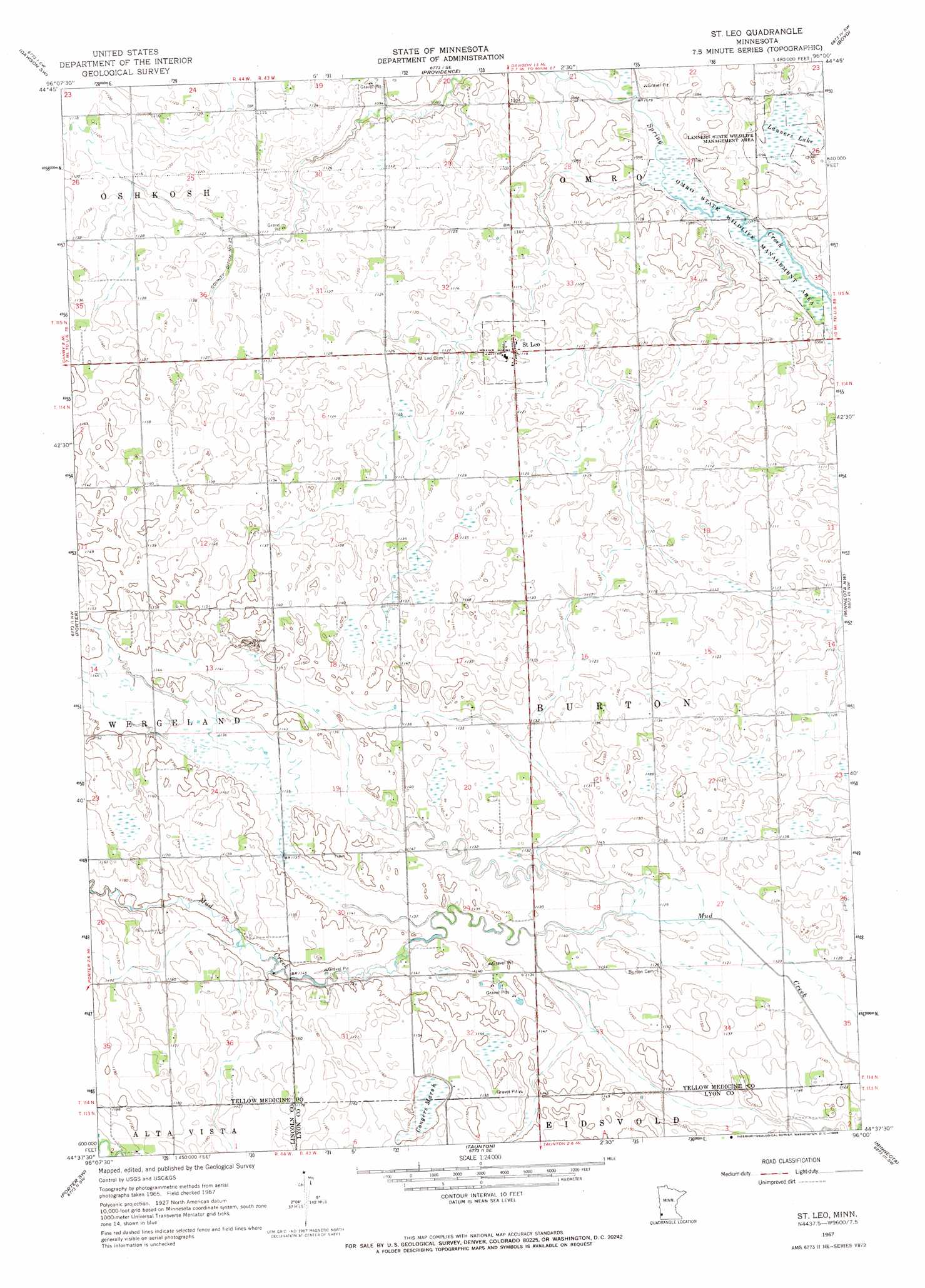
USGS Topo Quad 44096f1 - 1:24,000 scale
| Topo Map Name: | Saint Leo |
| USGS Topo Quad ID: | 44096f1 |
| Print Size: | ca. 21 1/4" wide x 27" high |
| Southeast Coordinates: | 44.625° N latitude / 96° W longitude |
| Map Center Coordinates: | 44.6875° N latitude / 96.0625° W longitude |
| U.S. State: | MN |
| Filename: | o44096f1.jpg |
| Download Map JPG Image: | Saint Leo topo map 1:24,000 scale |
| Map Type: | Topographic |
| Topo Series: | 7.5´ |
| Map Scale: | 1:24,000 |
| Source of Map Images: | United States Geological Survey (USGS) |
| Alternate Map Versions: |
St Leo MN 1967, updated 1968 Download PDF Buy paper map Saint Leo MN 2010 Download PDF Buy paper map Saint Leo MN 2013 Download PDF Buy paper map Saint Leo MN 2016 Download PDF Buy paper map |
1:24,000 Topo Quads surrounding Saint Leo
Mount Wickham |
Dawson Nw |
Dawson |
Tenmile Lake |
Clarkfield Ne |
Gary Se |
Dawson Sw |
Providence |
Boyd |
Clarkfield |
Canby |
Porter |
Saint Leo |
Minneota Nw |
Normania |
Canby Se |
Porter Sw |
Taunton |
Minneota |
Green Valley |
Lake Benton Ne |
Arco |
Gislason Lake |
Lynd |
Marshall |
> Back to 44096e1 at 1:100,000 scale
> Back to 44096a1 at 1:250,000 scale
> Back to U.S. Topo Maps home
Saint Leo topo map: Gazetteer
Saint Leo: Airports
Kochs Field elevation 346m 1135′Saint Leo: Canals
County Ditch Number Twentyfive elevation 342m 1122′Saint Leo: Parks
Lanners State Wildlife Management Area elevation 332m 1089′Omro State Wildlife Management Area elevation 329m 1079′
Saint Leo: Populated Places
Saint Leo elevation 342m 1122′Saint Leo: Post Offices
Saint Leo Post Office elevation 342m 1122′Saint Leo Post Office elevation 342m 1122′
Saint Leo: Swamps
Congers Marsh elevation 353m 1158′Lanners Lake elevation 332m 1089′
Saint Leo digital topo map on disk
Buy this Saint Leo topo map showing relief, roads, GPS coordinates and other geographical features, as a high-resolution digital map file on DVD:
Eastern North Dakota & Eastern South Dakota
Buy digital topo maps: Eastern North Dakota & Eastern South Dakota