Big Bend Dam Topo Map South Dakota
To zoom in, hover over the map of Big Bend Dam
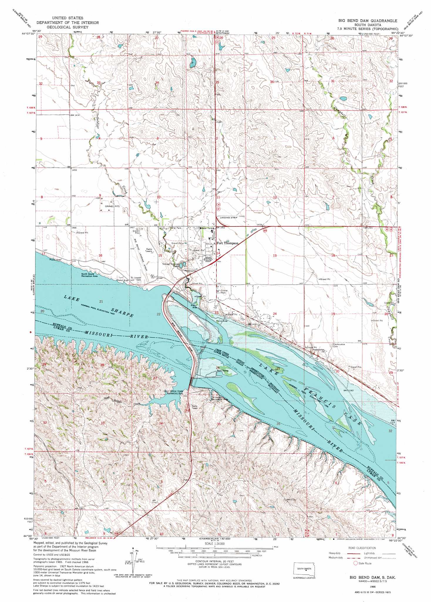
USGS Topo Quad 44099a4 - 1:24,000 scale
| Topo Map Name: | Big Bend Dam |
| USGS Topo Quad ID: | 44099a4 |
| Print Size: | ca. 21 1/4" wide x 27" high |
| Southeast Coordinates: | 44° N latitude / 99.375° W longitude |
| Map Center Coordinates: | 44.0625° N latitude / 99.4375° W longitude |
| U.S. State: | SD |
| Filename: | o44099a4.jpg |
| Download Map JPG Image: | Big Bend Dam topo map 1:24,000 scale |
| Map Type: | Topographic |
| Topo Series: | 7.5´ |
| Map Scale: | 1:24,000 |
| Source of Map Images: | United States Geological Survey (USGS) |
| Alternate Map Versions: |
Big Bend Dam SD 1966, updated 1967 Download PDF Buy paper map Big Bend Dam SD 2012 Download PDF Buy paper map Big Bend Dam SD 2015 Download PDF Buy paper map |
1:24,000 Topo Quads surrounding Big Bend Dam
Chapelle Lake Sw |
Chapelle Lake Se |
Macs Corner |
Macs Corner Se |
Miller Dale Colony Sw |
Lower Brule Nw |
Lower Brule Ne |
Stephan |
Big Bend Dam Ne |
Big Bend Dam 4 Nw |
Lower Brule Sw |
Lower Brule |
Big Bend Dam |
Big Bend Dam Se |
Big Bend Dam 4 Sw |
Lyman |
Reliance |
Short Creek |
Bedashosha Lake |
Shelby |
Reliance Sw |
Reliance Se |
Oacoma |
Chamberlain |
Pukwana |
> Back to 44099a1 at 1:100,000 scale
> Back to 44098a1 at 1:250,000 scale
> Back to U.S. Topo Maps home
Big Bend Dam topo map: Gazetteer
Big Bend Dam: Airports
Big Bend Landing Strip elevation 448m 1469′Big Bend Dam: Dams
Big Bend Dam elevation 440m 1443′Big Bend Dam: Parks
Fort Thompson Recreation Area elevation 421m 1381′Good Soldier Creek Recreation Area elevation 438m 1437′
North Shore Recreation Area elevation 443m 1453′
Tailwaters Recreation Area elevation 422m 1384′
Trailwaters Recreation Area elevation 417m 1368′
Big Bend Dam: Populated Places
Fort Thompson elevation 439m 1440′Big Bend Dam: Reservoirs
Lake Sharpe elevation 440m 1443′Big Bend Dam: Streams
Good Soldier Creek elevation 433m 1420′Soldier Creek elevation 413m 1354′
Big Bend Dam digital topo map on disk
Buy this Big Bend Dam topo map showing relief, roads, GPS coordinates and other geographical features, as a high-resolution digital map file on DVD:
Eastern North Dakota & Eastern South Dakota
Buy digital topo maps: Eastern North Dakota & Eastern South Dakota