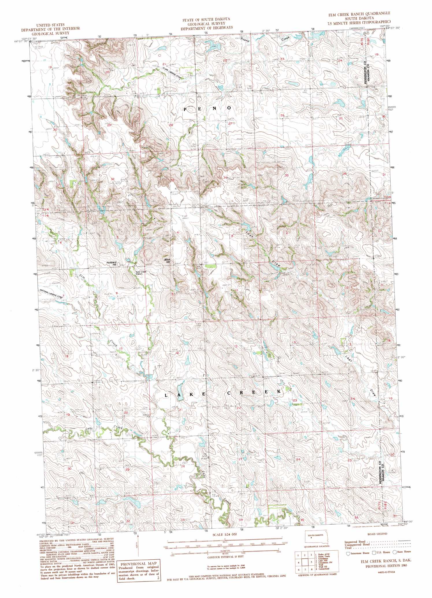
Elm Creek Ranch Topo Map South Dakota
To zoom in, hover over the map of Elm Creek Ranch
USGS Topo Quad 44102a1 - 1:24,000 scale
| Topo Map Name: | Elm Creek Ranch |
| USGS Topo Quad ID: | 44102a1 |
| Print Size: | ca. 21 1/4" wide x 27" high |
| Southeast Coordinates: | 44° N latitude / 102° W longitude |
| Map Center Coordinates: | 44.0625° N latitude / 102.0625° W longitude |
| U.S. State: | SD |
| Filename: | o44102a1.jpg |
| Download Map JPG Image: | Elm Creek Ranch topo map 1:24,000 scale |
| Map Type: | Topographic |
| Topo Series: | 7.5´ |
| Map Scale: | 1:24,000 |
| Source of Map Images: | United States Geological Survey (USGS) |
| Alternate Map Versions: |
Elm Creek Ranch SD 1983, updated 1984 Download PDF Buy paper map Elm Creek Ranch SD 2012 Download PDF Buy paper map Elm Creek Ranch SD 2015 Download PDF Buy paper map |
1:24,000 Topo Quads surrounding Elm Creek Ranch
Dalzell Se |
Creighton |
Pedro Se |
Post Ranch |
Hilland |
Wasta Ne |
Pedrow 4 Nw |
Horse Tooth |
Grindstone |
Grindstone Butte |
Wasta Se |
Lake Hill |
Elm Creek Ranch |
Grindstone Sw |
Bowen Ranch |
Quinn Table Ne |
Wall |
Wall Ne |
Cottonwood |
Cottonwood Ne |
Quinn Table Se |
Wall Sw |
Wall Se |
Cottonwood Sw |
Cottonwood Se |
> Back to 44102a1 at 1:100,000 scale
> Back to 44102a1 at 1:250,000 scale
> Back to U.S. Topo Maps home
Elm Creek Ranch topo map: Gazetteer
Elm Creek Ranch: Airports
Clark Landing Strip elevation 805m 2641′Hoffman Landing Strip elevation 816m 2677′
Elm Creek Ranch: Dams
George Kjerstad Dam elevation 807m 2647′Joe Papousek Dam elevation 787m 2582′
Konrad Kjerstad Dam elevation 835m 2739′
Leonard Kjerstad Number 2 Dam elevation 826m 2709′
Leonard Kjerstad Number 3 Dam elevation 833m 2732′
Sieler Dam elevation 791m 2595′
Theodore Kjerstad Dam elevation 841m 2759′
Tony Krebs Dam elevation 799m 2621′
Elm Creek Ranch: Streams
Elm Creek elevation 781m 2562′Elm Creek Ranch: Summits
Bliss Hill elevation 867m 2844′Hubbard Hill elevation 840m 2755′
Elm Creek Ranch digital topo map on disk
Buy this Elm Creek Ranch topo map showing relief, roads, GPS coordinates and other geographical features, as a high-resolution digital map file on DVD:
Eastern Wyoming & Western South Dakota
Buy digital topo maps: Eastern Wyoming & Western South Dakota