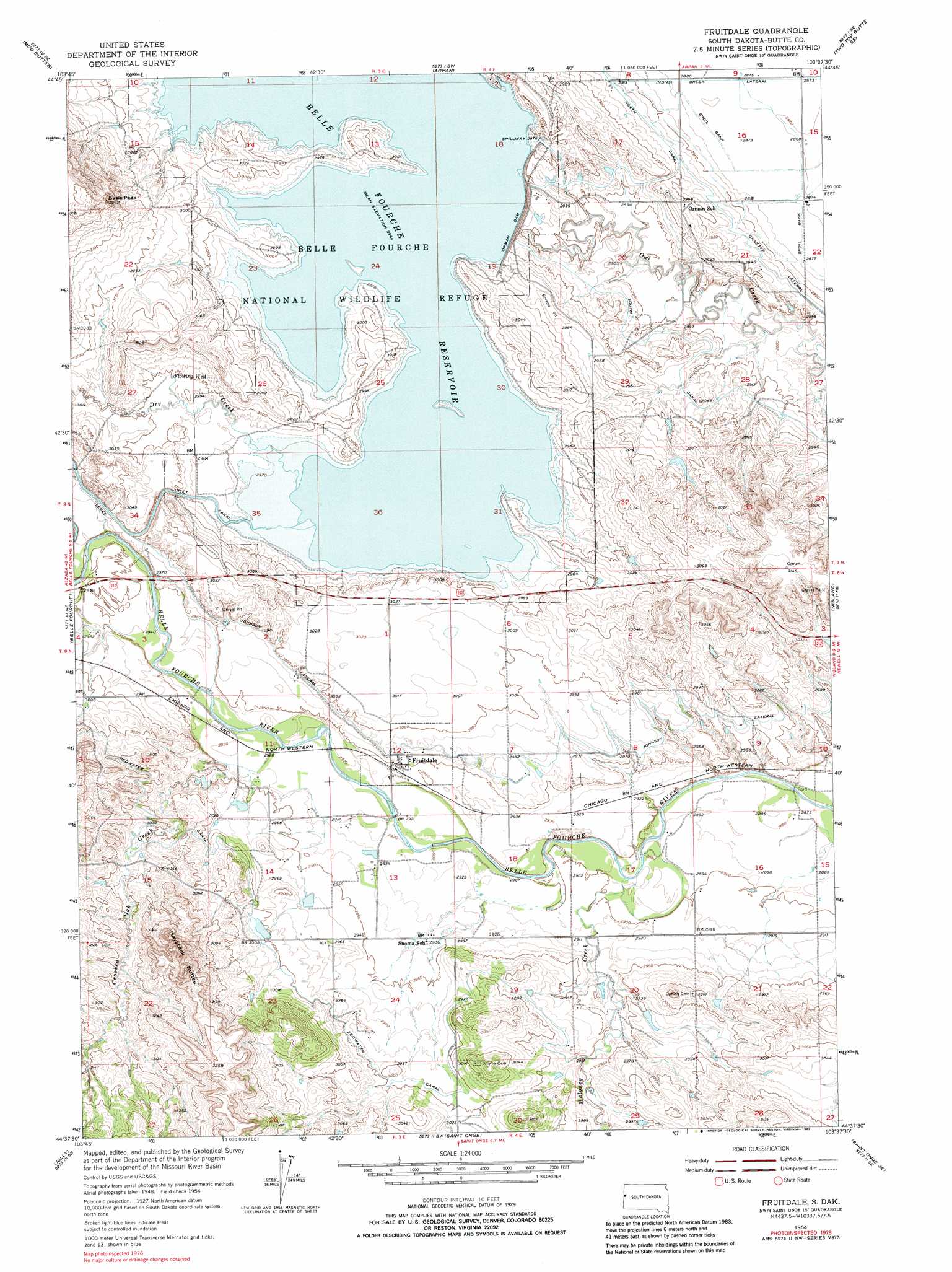
Fruitdale Topo Map South Dakota
To zoom in, hover over the map of Fruitdale
USGS Topo Quad 44103f6 - 1:24,000 scale
| Topo Map Name: | Fruitdale |
| USGS Topo Quad ID: | 44103f6 |
| Print Size: | ca. 21 1/4" wide x 27" high |
| Southeast Coordinates: | 44.625° N latitude / 103.625° W longitude |
| Map Center Coordinates: | 44.6875° N latitude / 103.6875° W longitude |
| U.S. State: | SD |
| Filename: | o44103f6.jpg |
| Download Map JPG Image: | Fruitdale topo map 1:24,000 scale |
| Map Type: | Topographic |
| Topo Series: | 7.5´ |
| Map Scale: | 1:24,000 |
| Source of Map Images: | United States Geological Survey (USGS) |
| Alternate Map Versions: |
Fruitdale SD 1954, updated 1956 Download PDF Buy paper map Fruitdale SD 1954, updated 1968 Download PDF Buy paper map Fruitdale SD 1954, updated 1983 Download PDF Buy paper map Fruitdale SD 2012 Download PDF Buy paper map Fruitdale SD 2015 Download PDF Buy paper map |
1:24,000 Topo Quads surrounding Fruitdale
Mud Buttes Nw |
Antelope Butte |
Two Top Butte West |
Two Top Butte East |
Castle Rock |
Bull Creek Butte |
Mud Buttes |
Arpan |
Two Top Butte Se |
Newell Lake |
Sourdough Flats |
Belle Fourche |
Fruitdale |
Nisland |
Newell |
Chicken Creek |
Jolly |
Saint Onge |
Saint Onge Se |
Vale |
Maurice |
Spearfish |
Deadwood North |
Sturgis |
Fort Meade |
> Back to 44103e1 at 1:100,000 scale
> Back to 44102a1 at 1:250,000 scale
> Back to U.S. Topo Maps home
Fruitdale topo map: Gazetteer
Fruitdale: Canals
Johnson Lateral elevation 903m 2962′Fruitdale: Dams
Belle Fourche Dam elevation 903m 2962′George Merickson Dam Number 1 elevation 909m 2982′
Orman Dam elevation 906m 2972′
Orman Dam elevation 903m 2962′
Fruitdale: Parks
Belle Fourche National Wildlife Refuge elevation 907m 2975′Fruitdale: Populated Places
Fruitdale elevation 899m 2949′Snoma (historical) elevation 894m 2933′
Fruitdale: Ranges
Haystack Buttes elevation 976m 3202′Fruitdale: Reservoirs
Belle Fourche Reservoir elevation 903m 2962′Fruitdale: Streams
Crooked Oak Creek elevation 890m 2919′Dry Creek elevation 905m 2969′
Maloney Creek elevation 881m 2890′
Fruitdale: Summits
Susie Peak elevation 974m 3195′Fruitdale: Wells
Flowing Well elevation 914m 2998′Fruitdale digital topo map on disk
Buy this Fruitdale topo map showing relief, roads, GPS coordinates and other geographical features, as a high-resolution digital map file on DVD:
Eastern Wyoming & Western South Dakota
Buy digital topo maps: Eastern Wyoming & Western South Dakota