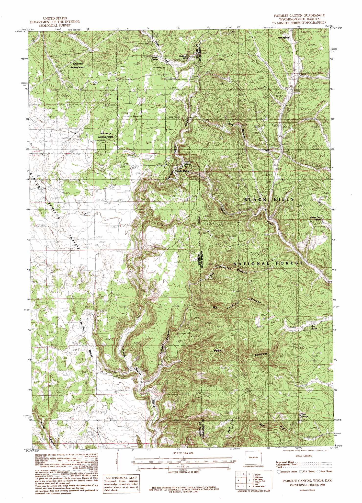
Parmlee Canyon Topo Map Wyoming
To zoom in, hover over the map of Parmlee Canyon
USGS Topo Quad 44104a1 - 1:24,000 scale
| Topo Map Name: | Parmlee Canyon |
| USGS Topo Quad ID: | 44104a1 |
| Print Size: | ca. 21 1/4" wide x 27" high |
| Southeast Coordinates: | 44° N latitude / 104° W longitude |
| Map Center Coordinates: | 44.0625° N latitude / 104.0625° W longitude |
| U.S. States: | WY, SD |
| Filename: | o44104a1.jpg |
| Download Map JPG Image: | Parmlee Canyon topo map 1:24,000 scale |
| Map Type: | Topographic |
| Topo Series: | 7.5´ |
| Map Scale: | 1:24,000 |
| Source of Map Images: | United States Geological Survey (USGS) |
| Alternate Map Versions: |
Parmlee Canyon WY 1984, updated 1984 Download PDF Buy paper map Parmlee Canyon WY 2012 Download PDF Buy paper map Parmlee Canyon WY 2015 Download PDF Buy paper map |
| FStopo: | US Forest Service topo Parmlee Canyon is available: Download FStopo PDF Download FStopo TIF |
1:24,000 Topo Quads surrounding Parmlee Canyon
Duling Hill |
Moskee |
Old Baldy Mountain |
Savoy |
Lead |
Inyan Kara Mountain |
Dry Draw |
Buckhorn |
Crooks Tower |
Nahant |
Skull Creek |
Four Corners |
Parmlee Canyon |
Crows Nest Peak |
Deerfield |
Pedro |
Cambria |
Moon |
Preacher Spring |
Ditch Creek |
Osage Se |
Newcastle |
Fanny Peak |
Dead Horse Flats |
Signal Hill |
> Back to 44104a1 at 1:100,000 scale
> Back to 44104a1 at 1:250,000 scale
> Back to U.S. Topo Maps home
Parmlee Canyon topo map: Gazetteer
Parmlee Canyon: Mines
Morrison Pit Mine elevation 1833m 6013′Parmlee Canyon: Ranges
Bald Hills elevation 1946m 6384′Parmlee Canyon: Springs
Austin Spring elevation 1931m 6335′Bear Spring elevation 2022m 6633′
Freel Spring elevation 2019m 6624′
Slicker Dick Spring elevation 2069m 6788′
State Line Spring elevation 1957m 6420′
Twin Springs elevation 2005m 6578′
Parmlee Canyon: Streams
Beaver Creek elevation 1837m 6026′Dry Beaver Creek elevation 1885m 6184′
Parmlee Canyon: Valleys
Bear Canyon elevation 1672m 5485′Bear Canyon elevation 1673m 5488′
Dry Parmlee Canyon elevation 1792m 5879′
Dry Parmlee Canyon elevation 1792m 5879′
Parmlee Canyon elevation 1639m 5377′
Wet Parmlee Canyon elevation 1814m 5951′
Parmlee Canyon digital topo map on disk
Buy this Parmlee Canyon topo map showing relief, roads, GPS coordinates and other geographical features, as a high-resolution digital map file on DVD:
Eastern Wyoming & Western South Dakota
Buy digital topo maps: Eastern Wyoming & Western South Dakota