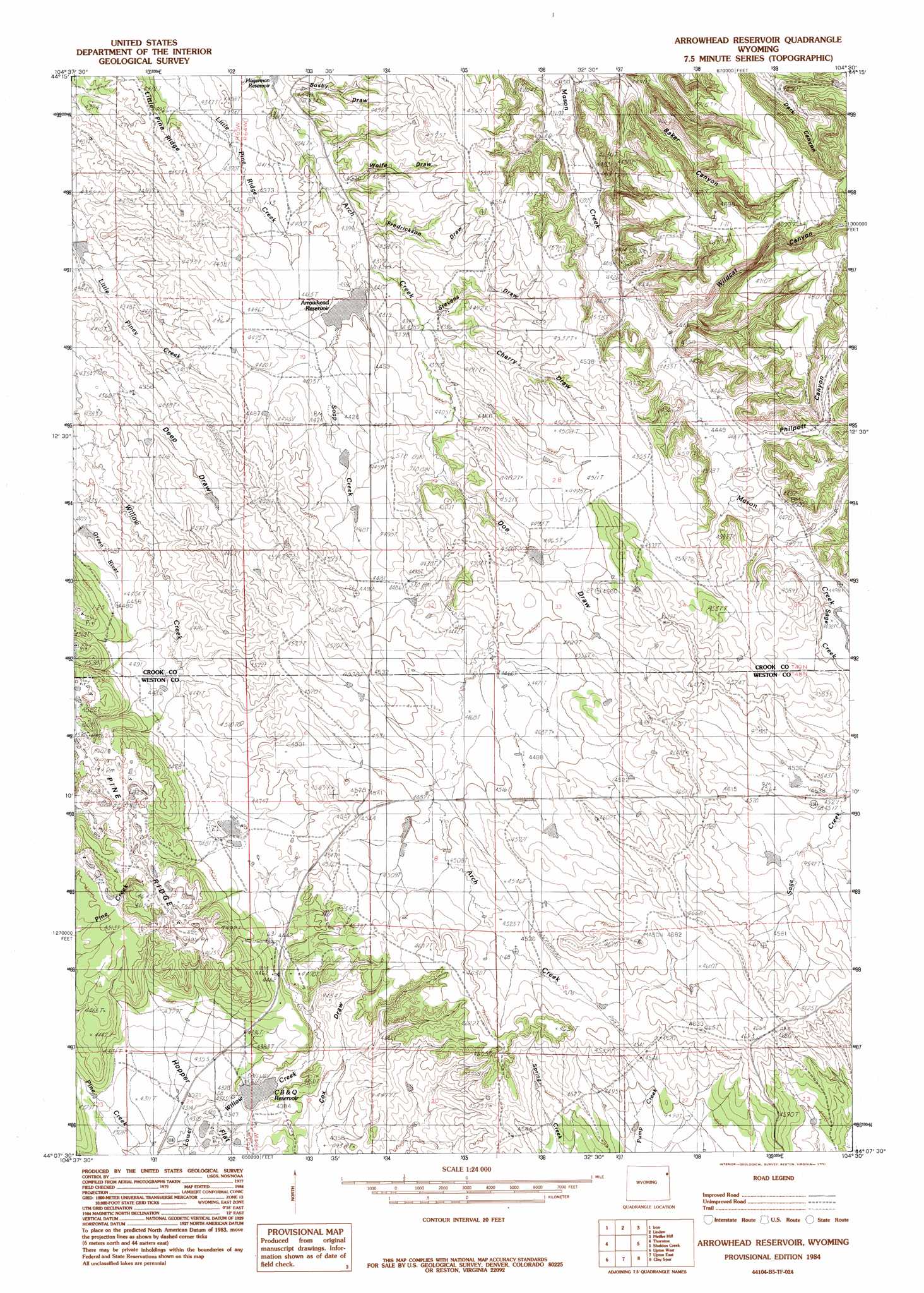
Arrowhead Reservoir Topo Map Wyoming
To zoom in, hover over the map of Arrowhead Reservoir
USGS Topo Quad 44104b5 - 1:24,000 scale
| Topo Map Name: | Arrowhead Reservoir |
| USGS Topo Quad ID: | 44104b5 |
| Print Size: | ca. 21 1/4" wide x 27" high |
| Southeast Coordinates: | 44.125° N latitude / 104.5° W longitude |
| Map Center Coordinates: | 44.1875° N latitude / 104.5625° W longitude |
| U.S. State: | WY |
| Filename: | o44104b5.jpg |
| Download Map JPG Image: | Arrowhead Reservoir topo map 1:24,000 scale |
| Map Type: | Topographic |
| Topo Series: | 7.5´ |
| Map Scale: | 1:24,000 |
| Source of Map Images: | United States Geological Survey (USGS) |
| Alternate Map Versions: |
Arrowhead Reservoir WY 1984, updated 1984 Download PDF Buy paper map Arrowhead Reservoir WY 1984, updated 1991 Download PDF Buy paper map Arrowhead Reservoir WY 2012 Download PDF Buy paper map Arrowhead Reservoir WY 2015 Download PDF Buy paper map |
| FStopo: | US Forest Service topo Arrowhead Reservoir is available: Download FStopo PDF Download FStopo TIF |
1:24,000 Topo Quads surrounding Arrowhead Reservoir
Carlile |
Wonder View |
The Rocks |
Sundance West |
Sundance East |
Grasshopper Butte |
Iron Mountain |
Linden |
Pfeiffer Hill |
Duling Hill |
Freda Creek |
Thornton |
Arrowhead Reservoir |
Sheldon Creek |
Inyan Kara Mountain |
Soda Butte |
Upton West |
Upton East |
Clay Spur |
Skull Creek |
West Fork Buffalo Creek |
Sheep Canyon Creek West |
Sheep Canyon Creek East |
Osage |
Pedro |
> Back to 44104a1 at 1:100,000 scale
> Back to 44104a1 at 1:250,000 scale
> Back to U.S. Topo Maps home
Arrowhead Reservoir topo map: Gazetteer
Arrowhead Reservoir: Dams
Arrohead Dam elevation 1339m 4393′Upton Dam elevation 1319m 4327′
Arrowhead Reservoir: Flats
Hopper Flat elevation 1316m 4317′Arrowhead Reservoir: Mines
Upton Bentonite Mine elevation 1385m 4543′Arrowhead Reservoir: Reservoirs
Arrohead Reservoir elevation 1339m 4393′Arrowhead Reservoir elevation 1339m 4393′
C B elevation 1330m 4363′
Upton Reservoir elevation 1319m 4327′
Arrowhead Reservoir: Streams
Mason Creek elevation 1330m 4363′Sage Creek elevation 1366m 4481′
Soap Creek elevation 1339m 4393′
Arrowhead Reservoir: Valleys
Baker Canyon elevation 1338m 4389′Busby Draw elevation 1330m 4363′
Cherry Draw elevation 1340m 4396′
Deep Draw elevation 1387m 4550′
Fredrickson Draw elevation 1335m 4379′
Philpott Canyon elevation 1363m 4471′
Stevens Draw elevation 1341m 4399′
Wildcat Canyon elevation 1357m 4452′
Wolfe Draw elevation 1332m 4370′
Arrowhead Reservoir digital topo map on disk
Buy this Arrowhead Reservoir topo map showing relief, roads, GPS coordinates and other geographical features, as a high-resolution digital map file on DVD:
Eastern Wyoming & Western South Dakota
Buy digital topo maps: Eastern Wyoming & Western South Dakota