Freda Creek Topo Map Wyoming
To zoom in, hover over the map of Freda Creek
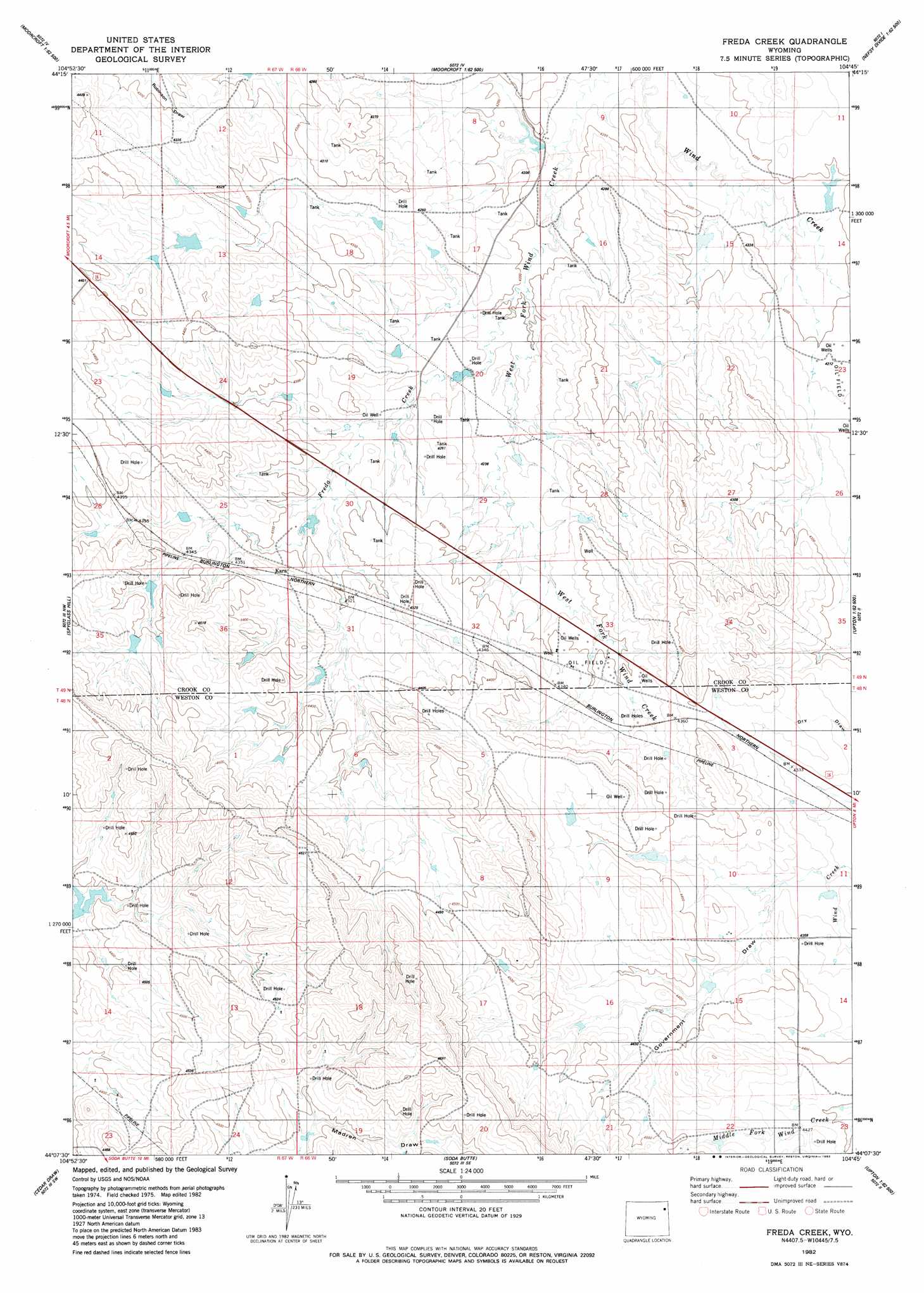
USGS Topo Quad 44104b7 - 1:24,000 scale
| Topo Map Name: | Freda Creek |
| USGS Topo Quad ID: | 44104b7 |
| Print Size: | ca. 21 1/4" wide x 27" high |
| Southeast Coordinates: | 44.125° N latitude / 104.75° W longitude |
| Map Center Coordinates: | 44.1875° N latitude / 104.8125° W longitude |
| U.S. State: | WY |
| Filename: | o44104b7.jpg |
| Download Map JPG Image: | Freda Creek topo map 1:24,000 scale |
| Map Type: | Topographic |
| Topo Series: | 7.5´ |
| Map Scale: | 1:24,000 |
| Source of Map Images: | United States Geological Survey (USGS) |
| Alternate Map Versions: |
Freda Creek WY 1982, updated 1982 Download PDF Buy paper map Freda Creek WY 2012 Download PDF Buy paper map Freda Creek WY 2015 Download PDF Buy paper map |
| FStopo: | US Forest Service topo Freda Creek is available: Download FStopo PDF Download FStopo TIF |
1:24,000 Topo Quads surrounding Freda Creek
Rozet Ne |
Edith Creek |
Carlile |
Wonder View |
The Rocks |
Rozet Se |
Moorcroft |
Grasshopper Butte |
Iron Mountain |
Linden |
Whitetail Creek Ne |
Spyglass Hill |
Freda Creek |
Thornton |
Arrowhead Reservoir |
Whitetail Creek Se |
Cedar Draw |
Soda Butte |
Upton West |
Upton East |
Jim Creek |
Raven |
West Fork Buffalo Creek |
Sheep Canyon Creek West |
Sheep Canyon Creek East |
> Back to 44104a1 at 1:100,000 scale
> Back to 44104a1 at 1:250,000 scale
> Back to U.S. Topo Maps home
Freda Creek topo map: Gazetteer
Freda Creek: Dams
Barton Dam elevation 1279m 4196′E E Wakeman Dam elevation 1275m 4183′
Mirich Dam elevation 1317m 4320′
Syndicate Dam elevation 1295m 4248′
Thomas Number 1 Dam elevation 1347m 4419′
Freda Creek: Reservoirs
Barton Reservoir elevation 1279m 4196′E E Wakeman Reservoir elevation 1275m 4183′
Mirich Reservoir elevation 1317m 4320′
Syndicate Reservoir elevation 1295m 4248′
Thomas Number 1 Reservoir elevation 1347m 4419′
Freda Creek: Springs
Willow Tree Springs elevation 1276m 4186′Freda Creek: Streams
Dumbrill Creek elevation 1276m 4186′Freda Creek elevation 1279m 4196′
Freda Creek: Valleys
Government Draw elevation 1317m 4320′Madren Draw elevation 1379m 4524′
Freda Creek digital topo map on disk
Buy this Freda Creek topo map showing relief, roads, GPS coordinates and other geographical features, as a high-resolution digital map file on DVD:
Eastern Wyoming & Western South Dakota
Buy digital topo maps: Eastern Wyoming & Western South Dakota