Red Canyon Creek Topo Map Wyoming
To zoom in, hover over the map of Red Canyon Creek
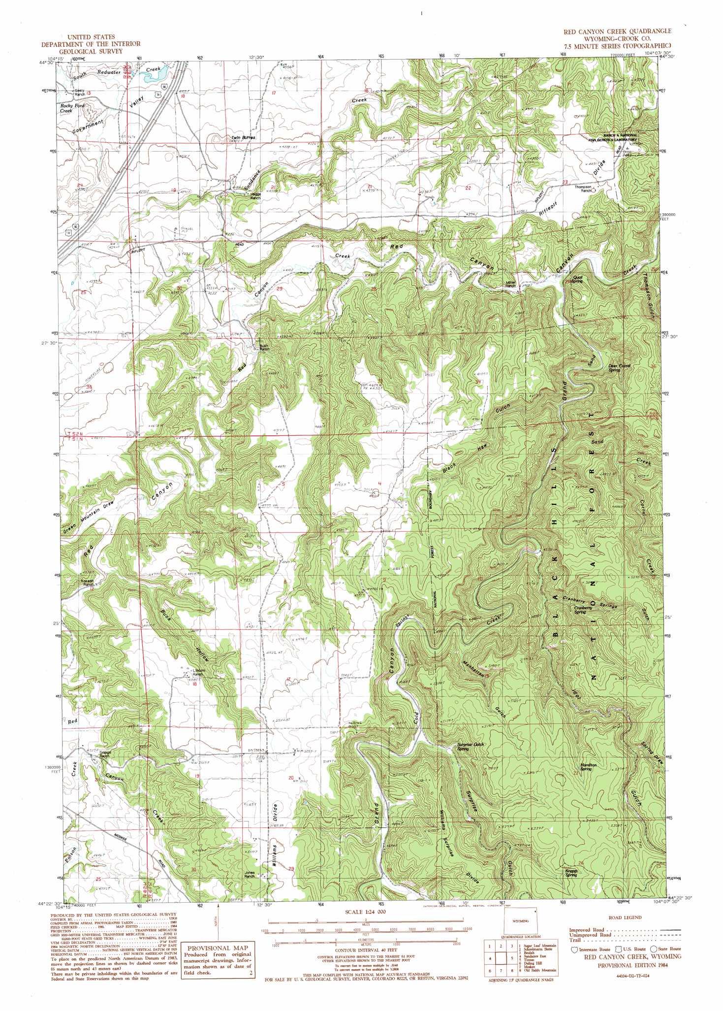
USGS Topo Quad 44104d2 - 1:24,000 scale
| Topo Map Name: | Red Canyon Creek |
| USGS Topo Quad ID: | 44104d2 |
| Print Size: | ca. 21 1/4" wide x 27" high |
| Southeast Coordinates: | 44.375° N latitude / 104.125° W longitude |
| Map Center Coordinates: | 44.4375° N latitude / 104.1875° W longitude |
| U.S. State: | WY |
| Filename: | o44104d2.jpg |
| Download Map JPG Image: | Red Canyon Creek topo map 1:24,000 scale |
| Map Type: | Topographic |
| Topo Series: | 7.5´ |
| Map Scale: | 1:24,000 |
| Source of Map Images: | United States Geological Survey (USGS) |
| Alternate Map Versions: |
Red Canyon Creek WY 1984, updated 1984 Download PDF Buy paper map Red Canyon Creek WY 2012 Download PDF Buy paper map Red Canyon Creek WY 2015 Download PDF Buy paper map |
| FStopo: | US Forest Service topo Red Canyon Creek is available: Download FStopo PDF Download FStopo TIF |
1:24,000 Topo Quads surrounding Red Canyon Creek
Alva |
The Notch |
Aladdin |
The Forks |
Sourdough Flats |
Black Hills |
Sugarloaf Mountain |
Schoolmarm Butte |
Beulah |
Chicken Creek |
Sundance West |
Sundance East |
Red Canyon Creek |
Tinton |
Maurice |
Pfeiffer Hill |
Duling Hill |
Moskee |
Old Baldy Mountain |
Savoy |
Sheldon Creek |
Inyan Kara Mountain |
Dry Draw |
Buckhorn |
Crooks Tower |
> Back to 44104a1 at 1:100,000 scale
> Back to 44104a1 at 1:250,000 scale
> Back to U.S. Topo Maps home
Red Canyon Creek topo map: Gazetteer
Red Canyon Creek: Dams
Rocky Ford Dam elevation 1231m 4038′Red Canyon Creek: Mines
Bear Creek Mountains Mine elevation 1258m 4127′Inum Group Mine elevation 1258m 4127′
Jones, Bury, and Murdock Property Number One Mine elevation 1590m 5216′
Red Canyon Creek: Reservoirs
Rocky Ford Reservoir elevation 1231m 4038′Red Canyon Creek: Ridges
Riflepit Divide elevation 1329m 4360′Williams Divide elevation 1587m 5206′
Red Canyon Creek: Springs
Cranberry Spring elevation 1358m 4455′Deer Corral Spring elevation 1237m 4058′
Hamilton Spring elevation 1565m 5134′
Knapp Spring elevation 1624m 5328′
Quail Spring elevation 1330m 4363′
Surprise Gulch Spring elevation 1436m 4711′
Red Canyon Creek: Streams
Cold Springs Creek elevation 1310m 4297′Cold Springs Creek elevation 1310m 4297′
Corral Creek elevation 1370m 4494′
Poison Creek elevation 1374m 4507′
Red Canyon Creek elevation 1202m 3943′
Rocky Ford Creek elevation 1256m 4120′
Red Canyon Creek: Valleys
Black Haw Gulch elevation 1308m 4291′Buck Hollow elevation 1341m 4399′
Cranberry Springs Gulch elevation 1363m 4471′
Grand Canyon elevation 1337m 4386′
Green Mountain Draw elevation 1331m 4366′
Idol Gulch elevation 1327m 4353′
Manhattan Gulch elevation 1379m 4524′
Spring Draw elevation 1553m 5095′
Surprise Gulch elevation 1406m 4612′
Thompson Gulch elevation 1200m 3937′
Red Canyon Creek digital topo map on disk
Buy this Red Canyon Creek topo map showing relief, roads, GPS coordinates and other geographical features, as a high-resolution digital map file on DVD:
Eastern Wyoming & Western South Dakota
Buy digital topo maps: Eastern Wyoming & Western South Dakota