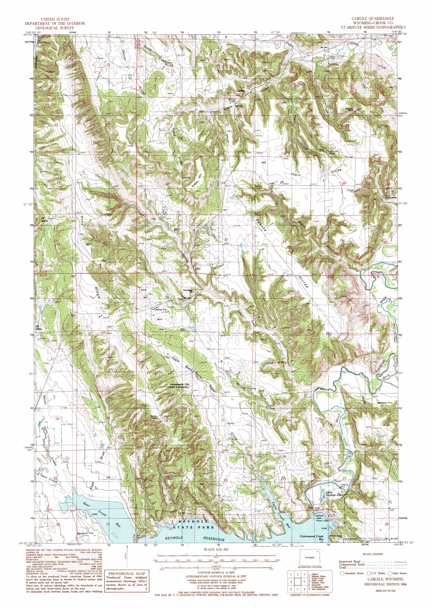
Carlile Topo Map Wyoming
To zoom in, hover over the map of Carlile
USGS Topo Quad 44104d7 - 1:24,000 scale
| Topo Map Name: | Carlile |
| USGS Topo Quad ID: | 44104d7 |
| Print Size: | ca. 21 1/4" wide x 27" high |
| Southeast Coordinates: | 44.375° N latitude / 104.75° W longitude |
| Map Center Coordinates: | 44.4375° N latitude / 104.8125° W longitude |
| U.S. State: | WY |
| Filename: | o44104d7.jpg |
| Download Map JPG Image: | Carlile topo map 1:24,000 scale |
| Map Type: | Topographic |
| Topo Series: | 7.5´ |
| Map Scale: | 1:24,000 |
| Source of Map Images: | United States Geological Survey (USGS) |
| Alternate Map Versions: |
Carlile WY 1954, updated 1954 Download PDF Buy paper map Carlile WY 1984, updated 1985 Download PDF Buy paper map Carlile WY 2012 Download PDF Buy paper map Carlile WY 2015 Download PDF Buy paper map |
1:24,000 Topo Quads surrounding Carlile
Brislawn School |
Garland Hill |
New Haven |
Moore Hill |
Hulett |
Flag Butte |
Oshoto |
Missouri Buttes |
Devils Tower |
Sherrard Hill |
Rozet Ne |
Edith Creek |
Carlile |
Wonder View |
The Rocks |
Rozet Se |
Moorcroft |
Grasshopper Butte |
Iron Mountain |
Linden |
Whitetail Creek Ne |
Spyglass Hill |
Freda Creek |
Thornton |
Arrowhead Reservoir |
> Back to 44104a1 at 1:100,000 scale
> Back to 44104a1 at 1:250,000 scale
> Back to U.S. Topo Maps home
Carlile topo map: Gazetteer
Carlile: Basins
Eggie Basin elevation 1290m 4232′Carlile: Dams
Keyhole Dam elevation 1246m 4087′Keyhole Dam elevation 1257m 4124′
Carlile: Lakes
Little Keyhole Lake elevation 1224m 4015′Carlile: Mines
Carlile Mine elevation 1280m 4199′Griffith Mine elevation 1271m 4169′
Homestake Two Mine elevation 1326m 4350′
Laymon Lease Mine elevation 1350m 4429′
Manke Lease Mine elevation 1354m 4442′
Pine Ridge Mine elevation 1403m 4603′
Pine Ridge Two Mine elevation 1287m 4222′
Shannon Lease Mine elevation 1341m 4399′
Thorn Mine elevation 1323m 4340′
Carlile: Pillars
Monumental City elevation 1295m 4248′Carlile: Populated Places
Carlile elevation 1270m 4166′Carlile: Reservoirs
Keyhole Reservoir elevation 1254m 4114′Carlile: Ridges
Dakota Divide elevation 1353m 4438′Pine Ridge elevation 1355m 4445′
Thorn Divide elevation 1331m 4366′
Carlile: Streams
Arch Creek elevation 1220m 4002′Dry Cabin Creek elevation 1226m 4022′
Eggie Creek elevation 1246m 4087′
Little Spring Creek elevation 1233m 4045′
North Deer Creek elevation 1248m 4094′
South Deer Creek elevation 1248m 4094′
Spring Creek elevation 1220m 4002′
Thorn Creek elevation 1239m 4064′
Carlile: Summits
Green Hill elevation 1419m 4655′Oil Butte elevation 1412m 4632′
Carlile: Valleys
Black Gulch elevation 1214m 3982′Little Draw elevation 1239m 4064′
Rock Draw elevation 1293m 4242′
Sage Draw elevation 1250m 4101′
Carlile digital topo map on disk
Buy this Carlile topo map showing relief, roads, GPS coordinates and other geographical features, as a high-resolution digital map file on DVD:
Eastern Wyoming & Western South Dakota
Buy digital topo maps: Eastern Wyoming & Western South Dakota