Devils Tower Topo Map Wyoming
To zoom in, hover over the map of Devils Tower
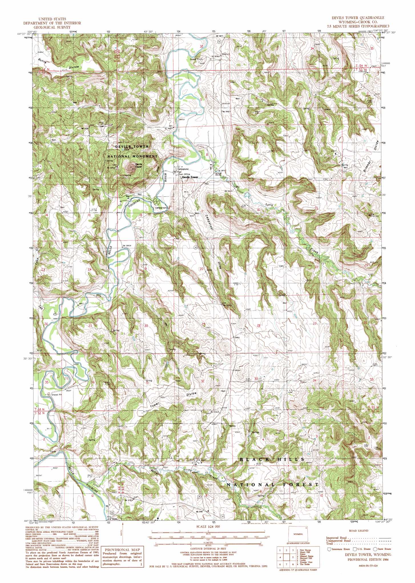
USGS Topo Quad 44104e6 - 1:24,000 scale
| Topo Map Name: | Devils Tower |
| USGS Topo Quad ID: | 44104e6 |
| Print Size: | ca. 21 1/4" wide x 27" high |
| Southeast Coordinates: | 44.5° N latitude / 104.625° W longitude |
| Map Center Coordinates: | 44.5625° N latitude / 104.6875° W longitude |
| U.S. State: | WY |
| Filename: | o44104e6.jpg |
| Download Map JPG Image: | Devils Tower topo map 1:24,000 scale |
| Map Type: | Topographic |
| Topo Series: | 7.5´ |
| Map Scale: | 1:24,000 |
| Source of Map Images: | United States Geological Survey (USGS) |
| Alternate Map Versions: |
Devils Tower WY 1984, updated 1985 Download PDF Buy paper map Devils Tower WY 1984, updated 1985 Download PDF Buy paper map Devils Tower WY 2012 Download PDF Buy paper map Devils Tower WY 2015 Download PDF Buy paper map |
| FStopo: | US Forest Service topo Devils Tower is available: Download FStopo PDF Download FStopo TIF |
1:24,000 Topo Quads surrounding Devils Tower
Cedar Ridge |
Wood Canyon |
Strawberry Hill |
Seely |
Mona |
Garland Hill |
New Haven |
Moore Hill |
Hulett |
Alva |
Oshoto |
Missouri Buttes |
Devils Tower |
Sherrard Hill |
Black Hills |
Edith Creek |
Carlile |
Wonder View |
The Rocks |
Sundance West |
Moorcroft |
Grasshopper Butte |
Iron Mountain |
Linden |
Pfeiffer Hill |
> Back to 44104e1 at 1:100,000 scale
> Back to 44104a1 at 1:250,000 scale
> Back to U.S. Topo Maps home
Devils Tower topo map: Gazetteer
Devils Tower: Dams
Claudie Dam elevation 1266m 4153′Devils Tower: Mines
Belle Fourche River Number Two Mine elevation 1173m 3848′Campstool Eleven Mine elevation 1182m 3877′
Campstool Nine Mine elevation 1182m 3877′
Nubeth Joint Venture Mine elevation 1264m 4146′
Devils Tower: Populated Places
Carlile Junction elevation 1281m 4202′Devils Tower elevation 1179m 3868′
Devils Tower: Post Offices
Devils Tower Post Office elevation 1176m 3858′Devils Tower: Reservoirs
Claudie Reservoir elevation 1266m 4153′Devils Tower: Ridges
Tower Divide elevation 1379m 4524′Devils Tower: Streams
Left Creek elevation 1183m 3881′Lytle Creek elevation 1171m 3841′
Miller Creek elevation 1195m 3920′
Devils Tower: Summits
Devils Tower elevation 1517m 4977′Devils Tower National Monument elevation 1287m 4222′
Devils Tower: Valleys
Campstool Draw elevation 1189m 3900′Devils Tower digital topo map on disk
Buy this Devils Tower topo map showing relief, roads, GPS coordinates and other geographical features, as a high-resolution digital map file on DVD:
Eastern Wyoming & Western South Dakota
Buy digital topo maps: Eastern Wyoming & Western South Dakota