Whitetail Creek Topo Map Wyoming
To zoom in, hover over the map of Whitetail Creek
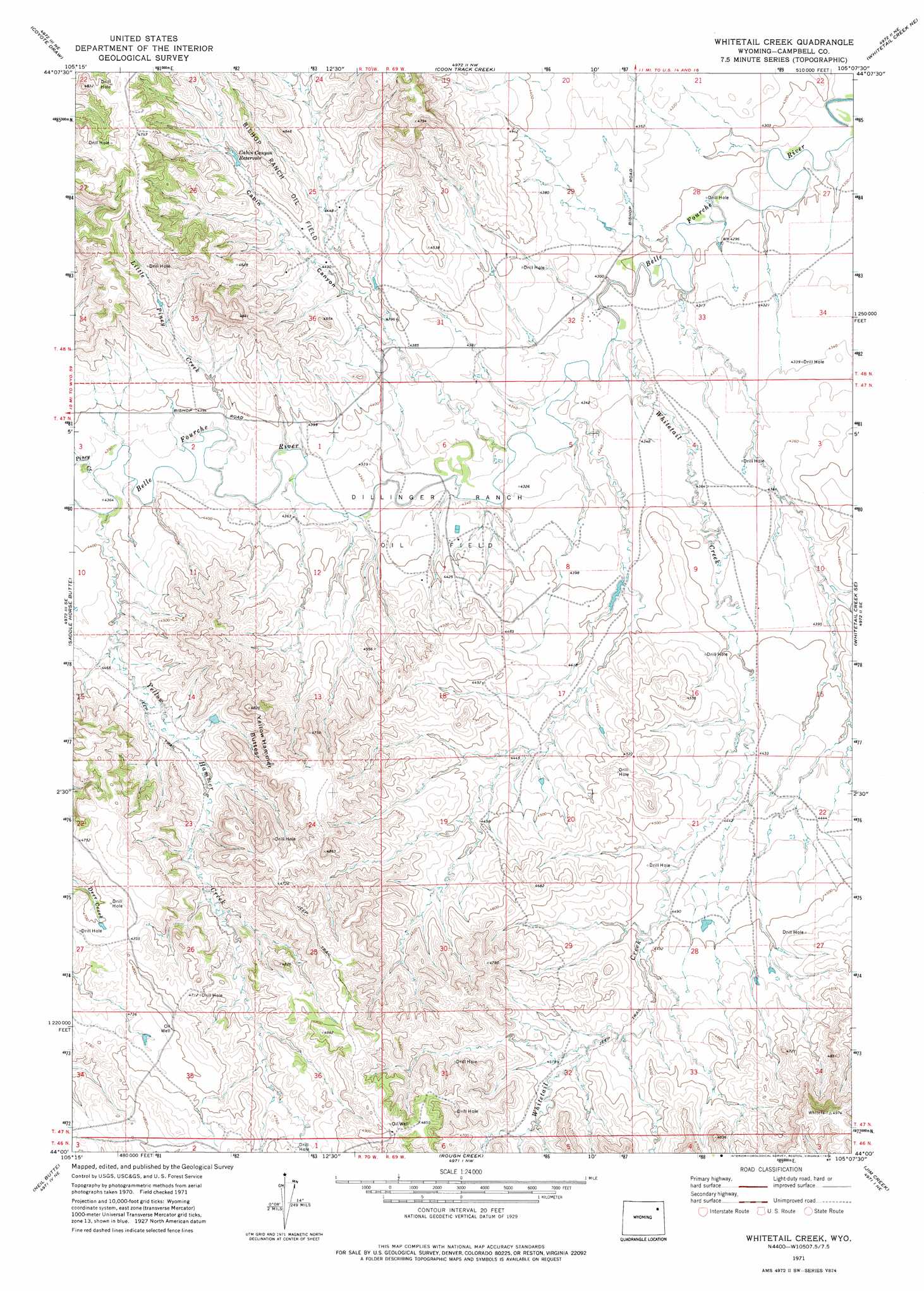
USGS Topo Quad 44105a2 - 1:24,000 scale
| Topo Map Name: | Whitetail Creek |
| USGS Topo Quad ID: | 44105a2 |
| Print Size: | ca. 21 1/4" wide x 27" high |
| Southeast Coordinates: | 44° N latitude / 105.125° W longitude |
| Map Center Coordinates: | 44.0625° N latitude / 105.1875° W longitude |
| U.S. State: | WY |
| Filename: | o44105a2.jpg |
| Download Map JPG Image: | Whitetail Creek topo map 1:24,000 scale |
| Map Type: | Topographic |
| Topo Series: | 7.5´ |
| Map Scale: | 1:24,000 |
| Source of Map Images: | United States Geological Survey (USGS) |
| Alternate Map Versions: |
Whitetail Creek WY 1971, updated 1974 Download PDF Buy paper map Whitetail Creek WY 1971, updated 1974 Download PDF Buy paper map Whitetail Creek WY 2012 Download PDF Buy paper map Whitetail Creek WY 2015 Download PDF Buy paper map |
1:24,000 Topo Quads surrounding Whitetail Creek
Gillette East |
Fortin Draw |
Rozet |
Rozet Se |
Moorcroft |
The Gap |
Coyote Draw |
Coon Track Creek |
Whitetail Creek Ne |
Spyglass Hill |
The Gap Sw |
Saddle Horse Butte |
Whitetail Creek |
Whitetail Creek Se |
Cedar Draw |
Eagle Rock |
Neil Butte |
Rough Creek |
Jim Creek |
Raven |
Reno Junction |
Hilight |
Open A Ranch |
Buck Creek |
Wildlife Draw West |
> Back to 44105a1 at 1:100,000 scale
> Back to 44104a1 at 1:250,000 scale
> Back to U.S. Topo Maps home
Whitetail Creek topo map: Gazetteer
Whitetail Creek: Oilfields
Bishop Ranch Oil Field elevation 1377m 4517′Dillinger Ranch Oil Field elevation 1333m 4373′
Whitetail Creek: Reservoirs
Cabin Canyon Reservoir elevation 1371m 4498′Whitetail Creek: Streams
Little Piney Creek elevation 1324m 4343′Piney Creek elevation 1330m 4363′
Whitetail Creek elevation 1312m 4304′
Yellow Hammer Creek elevation 1330m 4363′
Whitetail Creek: Summits
Yellow Hammer Buttes elevation 1453m 4767′Whitetail Creek: Valleys
Cabin Canyon elevation 1339m 4393′Whitetail Creek digital topo map on disk
Buy this Whitetail Creek topo map showing relief, roads, GPS coordinates and other geographical features, as a high-resolution digital map file on DVD:
Eastern Wyoming & Western South Dakota
Buy digital topo maps: Eastern Wyoming & Western South Dakota