Scaper Reservoir Topo Map Wyoming
To zoom in, hover over the map of Scaper Reservoir
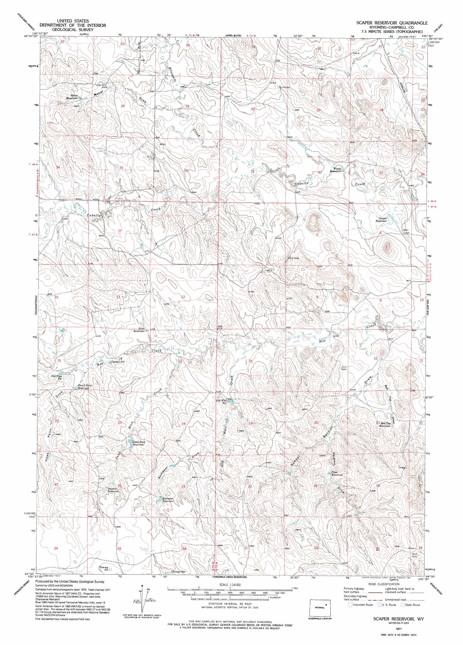
USGS Topo Quad 44105a5 - 1:24,000 scale
| Topo Map Name: | Scaper Reservoir |
| USGS Topo Quad ID: | 44105a5 |
| Print Size: | ca. 21 1/4" wide x 27" high |
| Southeast Coordinates: | 44° N latitude / 105.5° W longitude |
| Map Center Coordinates: | 44.0625° N latitude / 105.5625° W longitude |
| U.S. State: | WY |
| Filename: | o44105a5.jpg |
| Download Map JPG Image: | Scaper Reservoir topo map 1:24,000 scale |
| Map Type: | Topographic |
| Topo Series: | 7.5´ |
| Map Scale: | 1:24,000 |
| Source of Map Images: | United States Geological Survey (USGS) |
| Alternate Map Versions: |
Scaper Reservoir WY 1971, updated 1974 Download PDF Buy paper map Scaper Reservoir WY 1971, updated 1995 Download PDF Buy paper map Scaper Reservoir WY 2012 Download PDF Buy paper map Scaper Reservoir WY 2015 Download PDF Buy paper map |
1:24,000 Topo Quads surrounding Scaper Reservoir
Jeffers Draw |
Oriva |
Gillette West |
Gillette East |
Fortin Draw |
Scott Dam |
Four Bar J Ranch |
Appel Butte |
The Gap |
Coyote Draw |
Double Tanks |
Pleasantdale |
Scaper Reservoir |
The Gap Sw |
Saddle Horse Butte |
Wags Pinnacle |
Pepsson Draw |
Threemile Creek Reservoir |
Eagle Rock |
Neil Butte |
Savageton |
Greasewood Reservoir |
Rocky Butte Gulch |
Reno Junction |
Hilight |
> Back to 44105a1 at 1:100,000 scale
> Back to 44104a1 at 1:250,000 scale
> Back to U.S. Topo Maps home
Scaper Reservoir topo map: Gazetteer
Scaper Reservoir: Basins
Cattail Pit elevation 1438m 4717′Tammy Pit elevation 1506m 4940′
Scaper Reservoir: Dams
Flat Dam elevation 1400m 4593′Hoe Creek Dam elevation 1446m 4744′
Worth Dam elevation 1406m 4612′
Scaper Reservoir: Reservoirs
Buck Reservoir elevation 1439m 4721′Chicago Reservoir elevation 1487m 4878′
Dayton Reservoir elevation 1480m 4855′
Flat Reservoir elevation 1400m 4593′
Hawk Point Reservoir elevation 1450m 4757′
Hoe Creek Reservoir elevation 1446m 4744′
Moser Reservoir elevation 1455m 4773′
Piper Reservoir elevation 1439m 4721′
Red Top Reservoir elevation 1437m 4714′
Romaker Reservoir elevation 1482m 4862′
Sand Rock Reservoir elevation 1460m 4790′
Scaper Reservoir elevation 1394m 4573′
Worth Reservoir elevation 1396m 4580′
Scaper Reservoir: Streams
Bluegate Creek elevation 1432m 4698′Sand Rock Creek elevation 1428m 4685′
Scaper Reservoir: Valleys
Hawk Point Draw elevation 1445m 4740′Moser Draw elevation 1414m 4639′
Old Well Draw elevation 1441m 4727′
Red Top Draw elevation 1415m 4642′
Romaker Draw elevation 1445m 4740′
School Section Draw elevation 1409m 4622′
Thielen Draw elevation 1431m 4694′
Scaper Reservoir digital topo map on disk
Buy this Scaper Reservoir topo map showing relief, roads, GPS coordinates and other geographical features, as a high-resolution digital map file on DVD:
Eastern Wyoming & Western South Dakota
Buy digital topo maps: Eastern Wyoming & Western South Dakota