Pleasantdale Topo Map Wyoming
To zoom in, hover over the map of Pleasantdale
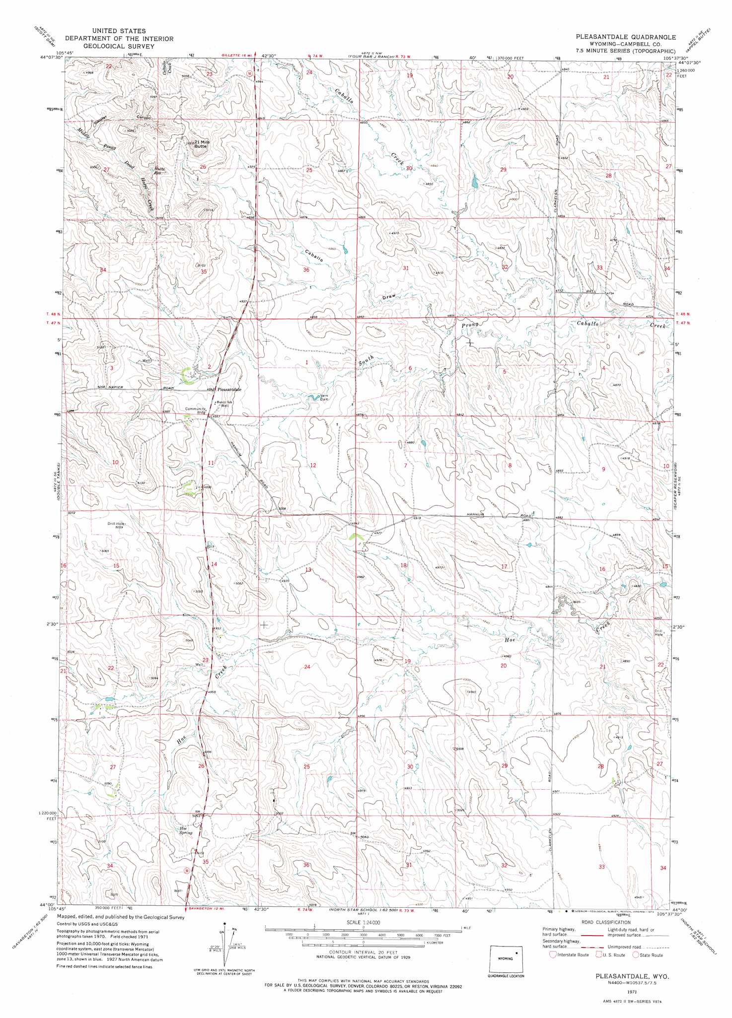
USGS Topo Quad 44105a6 - 1:24,000 scale
| Topo Map Name: | Pleasantdale |
| USGS Topo Quad ID: | 44105a6 |
| Print Size: | ca. 21 1/4" wide x 27" high |
| Southeast Coordinates: | 44° N latitude / 105.625° W longitude |
| Map Center Coordinates: | 44.0625° N latitude / 105.6875° W longitude |
| U.S. State: | WY |
| Filename: | o44105a6.jpg |
| Download Map JPG Image: | Pleasantdale topo map 1:24,000 scale |
| Map Type: | Topographic |
| Topo Series: | 7.5´ |
| Map Scale: | 1:24,000 |
| Source of Map Images: | United States Geological Survey (USGS) |
| Alternate Map Versions: |
Pleasantdale WY 1971, updated 1974 Download PDF Buy paper map Pleasantdale WY 2012 Download PDF Buy paper map Pleasantdale WY 2015 Download PDF Buy paper map |
1:24,000 Topo Quads surrounding Pleasantdale
Carr Draw |
Jeffers Draw |
Oriva |
Gillette West |
Gillette East |
Morgan Draw |
Scott Dam |
Four Bar J Ranch |
Appel Butte |
The Gap |
Bogie Draw |
Double Tanks |
Pleasantdale |
Scaper Reservoir |
The Gap Sw |
Fats Draw |
Wags Pinnacle |
Pepsson Draw |
Threemile Creek Reservoir |
Eagle Rock |
North Butte |
Savageton |
Greasewood Reservoir |
Rocky Butte Gulch |
Reno Junction |
> Back to 44105a1 at 1:100,000 scale
> Back to 44104a1 at 1:250,000 scale
> Back to U.S. Topo Maps home
Pleasantdale topo map: Gazetteer
Pleasantdale: Dams
Patra Number 2 Dam elevation 1474m 4835′Patra Number 3 Dam elevation 1452m 4763′
Pedersen Dam elevation 1455m 4773′
Vern Dam elevation 1478m 4849′
Pleasantdale: Populated Places
Pleasantdale elevation 1507m 4944′Pleasantdale: Reservoirs
Butte Reservoir elevation 1512m 4960′Patra Number 2 Reservoir elevation 1474m 4835′
Patra Number 3 Reservoir elevation 1452m 4763′
Pedersen Reservoir elevation 1455m 4773′
Pleasantdale: Springs
Hoe Spring elevation 1536m 5039′Pleasantdale: Streams
South Prong Caballo Creek elevation 1451m 4760′Pleasantdale: Summits
Twenty-one Mile Butte elevation 1576m 5170′Pleasantdale: Valleys
Caballo Draw elevation 1463m 4799′Rooster Canyon elevation 1488m 4881′
Pleasantdale digital topo map on disk
Buy this Pleasantdale topo map showing relief, roads, GPS coordinates and other geographical features, as a high-resolution digital map file on DVD:
Eastern Wyoming & Western South Dakota
Buy digital topo maps: Eastern Wyoming & Western South Dakota