Coon Track Creek Topo Map Wyoming
To zoom in, hover over the map of Coon Track Creek
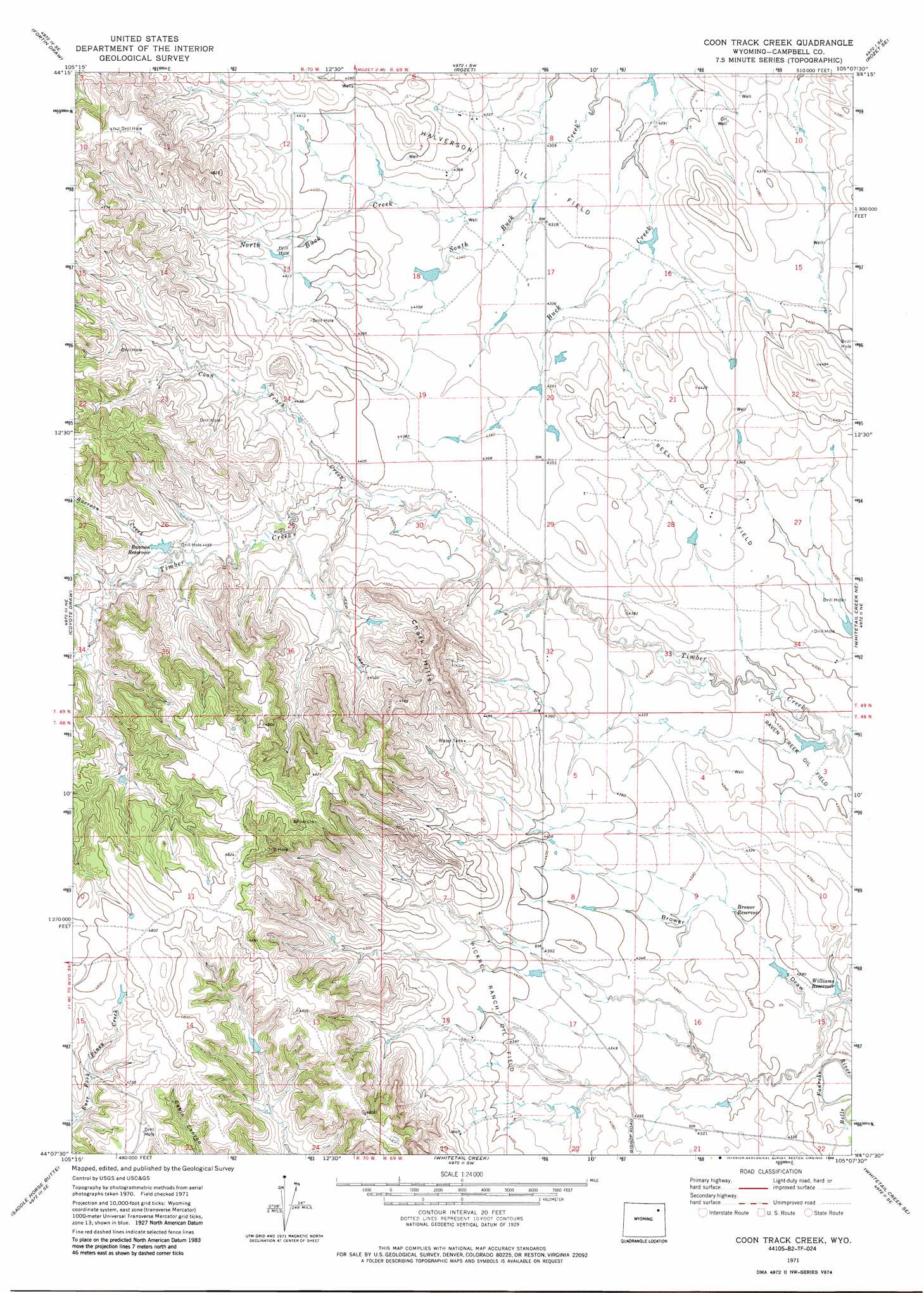
USGS Topo Quad 44105b2 - 1:24,000 scale
| Topo Map Name: | Coon Track Creek |
| USGS Topo Quad ID: | 44105b2 |
| Print Size: | ca. 21 1/4" wide x 27" high |
| Southeast Coordinates: | 44.125° N latitude / 105.125° W longitude |
| Map Center Coordinates: | 44.1875° N latitude / 105.1875° W longitude |
| U.S. State: | WY |
| Filename: | o44105b2.jpg |
| Download Map JPG Image: | Coon Track Creek topo map 1:24,000 scale |
| Map Type: | Topographic |
| Topo Series: | 7.5´ |
| Map Scale: | 1:24,000 |
| Source of Map Images: | United States Geological Survey (USGS) |
| Alternate Map Versions: |
Coon Track Creek WY 1971, updated 1974 Download PDF Buy paper map Coon Track Creek WY 1971, updated 1988 Download PDF Buy paper map Coon Track Creek WY 2012 Download PDF Buy paper map Coon Track Creek WY 2015 Download PDF Buy paper map |
1:24,000 Topo Quads surrounding Coon Track Creek
Moyer Springs |
Green Hill |
Rozet Nw |
Rozet Ne |
Edith Creek |
Gillette East |
Fortin Draw |
Rozet |
Rozet Se |
Moorcroft |
The Gap |
Coyote Draw |
Coon Track Creek |
Whitetail Creek Ne |
Spyglass Hill |
The Gap Sw |
Saddle Horse Butte |
Whitetail Creek |
Whitetail Creek Se |
Cedar Draw |
Eagle Rock |
Neil Butte |
Rough Creek |
Jim Creek |
Raven |
> Back to 44105a1 at 1:100,000 scale
> Back to 44104a1 at 1:250,000 scale
> Back to U.S. Topo Maps home
Coon Track Creek topo map: Gazetteer
Coon Track Creek: Oilfields
Halverson Oil Field elevation 1317m 4320′Pickrel Ranch Oil Field elevation 1338m 4389′
Reel Oil Field elevation 1327m 4353′
Coon Track Creek: Reservoirs
Brower Reservoir elevation 1312m 4304′Raccoon Reservoir elevation 1360m 4461′
Williams Reservoir elevation 1307m 4288′
Coon Track Creek: Streams
Coon Track Creek elevation 1330m 4363′North Buck Creek elevation 1315m 4314′
Raccoon Creek elevation 1354m 4442′
Coon Track Creek: Summits
Chalk Hills elevation 1466m 4809′Coon Track Creek: Valleys
Brower Draw elevation 1299m 4261′Coon Track Creek digital topo map on disk
Buy this Coon Track Creek topo map showing relief, roads, GPS coordinates and other geographical features, as a high-resolution digital map file on DVD:
Eastern Wyoming & Western South Dakota
Buy digital topo maps: Eastern Wyoming & Western South Dakota