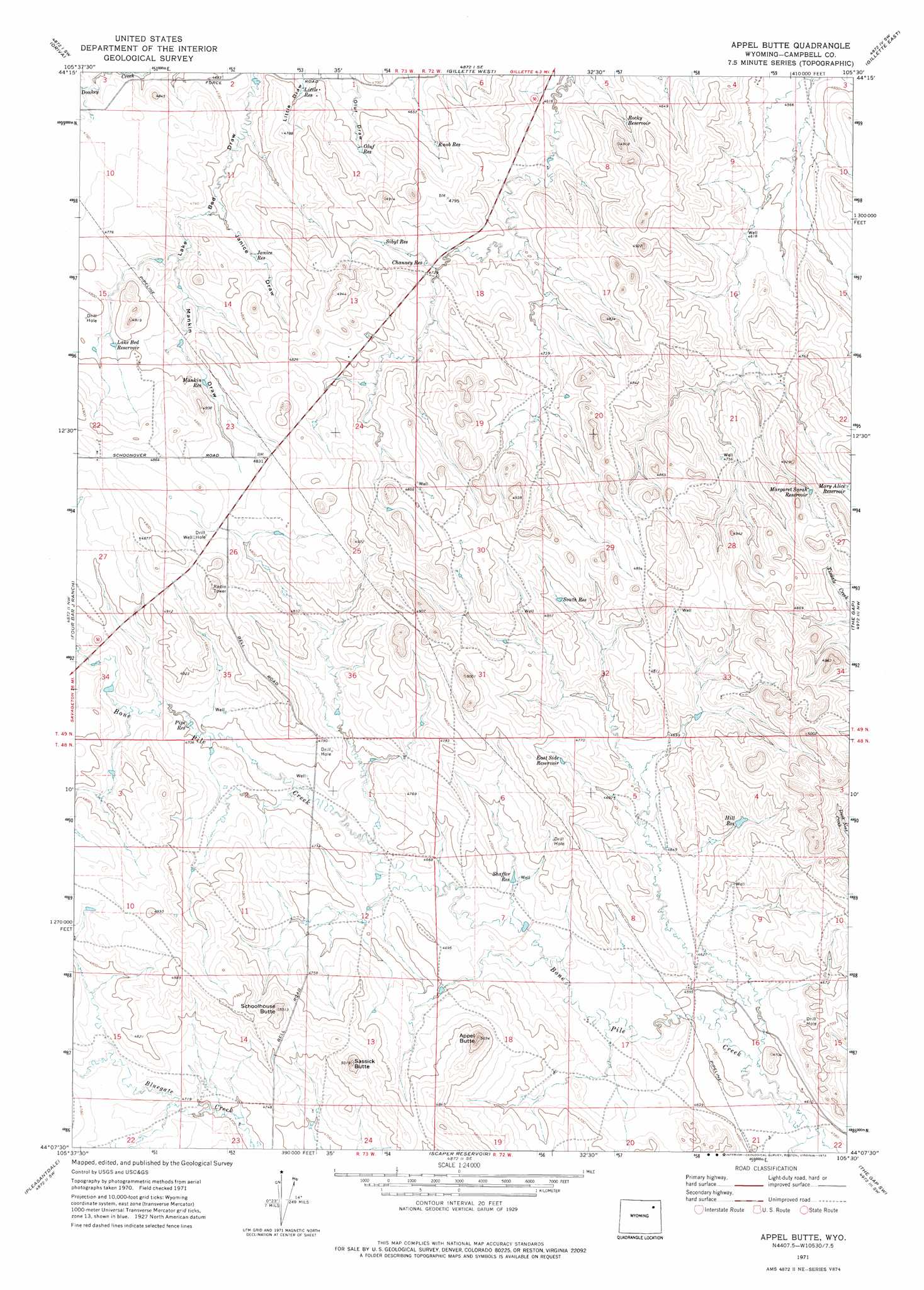
Appel Butte Topo Map Wyoming
To zoom in, hover over the map of Appel Butte
USGS Topo Quad 44105b5 - 1:24,000 scale
| Topo Map Name: | Appel Butte |
| USGS Topo Quad ID: | 44105b5 |
| Print Size: | ca. 21 1/4" wide x 27" high |
| Southeast Coordinates: | 44.125° N latitude / 105.5° W longitude |
| Map Center Coordinates: | 44.1875° N latitude / 105.5625° W longitude |
| U.S. State: | WY |
| Filename: | o44105b5.jpg |
| Download Map JPG Image: | Appel Butte topo map 1:24,000 scale |
| Map Type: | Topographic |
| Topo Series: | 7.5´ |
| Map Scale: | 1:24,000 |
| Source of Map Images: | United States Geological Survey (USGS) |
| Alternate Map Versions: |
Appel Butte WY 1971, updated 1974 Download PDF Buy paper map Appel Butte WY 1971, updated 1974 Download PDF Buy paper map Appel Butte WY 2012 Download PDF Buy paper map Appel Butte WY 2015 Download PDF Buy paper map |
1:24,000 Topo Quads surrounding Appel Butte
Twentymile Butte |
Oriva Nw |
Rawhide School |
Moyer Springs |
Green Hill |
Jeffers Draw |
Oriva |
Gillette West |
Gillette East |
Fortin Draw |
Scott Dam |
Four Bar J Ranch |
Appel Butte |
The Gap |
Coyote Draw |
Double Tanks |
Pleasantdale |
Scaper Reservoir |
The Gap Sw |
Saddle Horse Butte |
Wags Pinnacle |
Pepsson Draw |
Threemile Creek Reservoir |
Eagle Rock |
Neil Butte |
> Back to 44105a1 at 1:100,000 scale
> Back to 44104a1 at 1:250,000 scale
> Back to U.S. Topo Maps home
Appel Butte topo map: Gazetteer
Appel Butte: Dams
Stone Number 2 Dam elevation 1415m 4642′Appel Butte: Reservoirs
Channey Reservoir elevation 1438m 4717′East Side Reservoir elevation 1446m 4744′
Hill Reservoir elevation 1434m 4704′
Janice Reservoir elevation 1439m 4721′
Knob Reservoir elevation 1427m 4681′
Lake Bed Reservoir elevation 1458m 4783′
Little Reservoir elevation 1428m 4685′
Mankin Reservoir elevation 1454m 4770′
Margaret Sarah Reservoir elevation 1465m 4806′
Mary Alice Reservoir elevation 1456m 4776′
Oluf Reservoir elevation 1434m 4704′
Pipe Reservoir elevation 1433m 4701′
Rocky Reservoir elevation 1432m 4698′
Shaffer Reservoir elevation 1416m 4645′
Sibyl Reservoir elevation 1448m 4750′
South Reservoir elevation 1455m 4773′
Stone Number 2 Reservoir elevation 1415m 4642′
Appel Butte: Summits
Appel Butte elevation 1524m 5000′Sassick Butte elevation 1522m 4993′
Schoolhouse Butte elevation 1506m 4940′
Appel Butte: Valleys
Janice Draw elevation 1433m 4701′Lake Bed Draw elevation 1418m 4652′
Mankin Draw elevation 1440m 4724′
Appel Butte digital topo map on disk
Buy this Appel Butte topo map showing relief, roads, GPS coordinates and other geographical features, as a high-resolution digital map file on DVD:
Eastern Wyoming & Western South Dakota
Buy digital topo maps: Eastern Wyoming & Western South Dakota