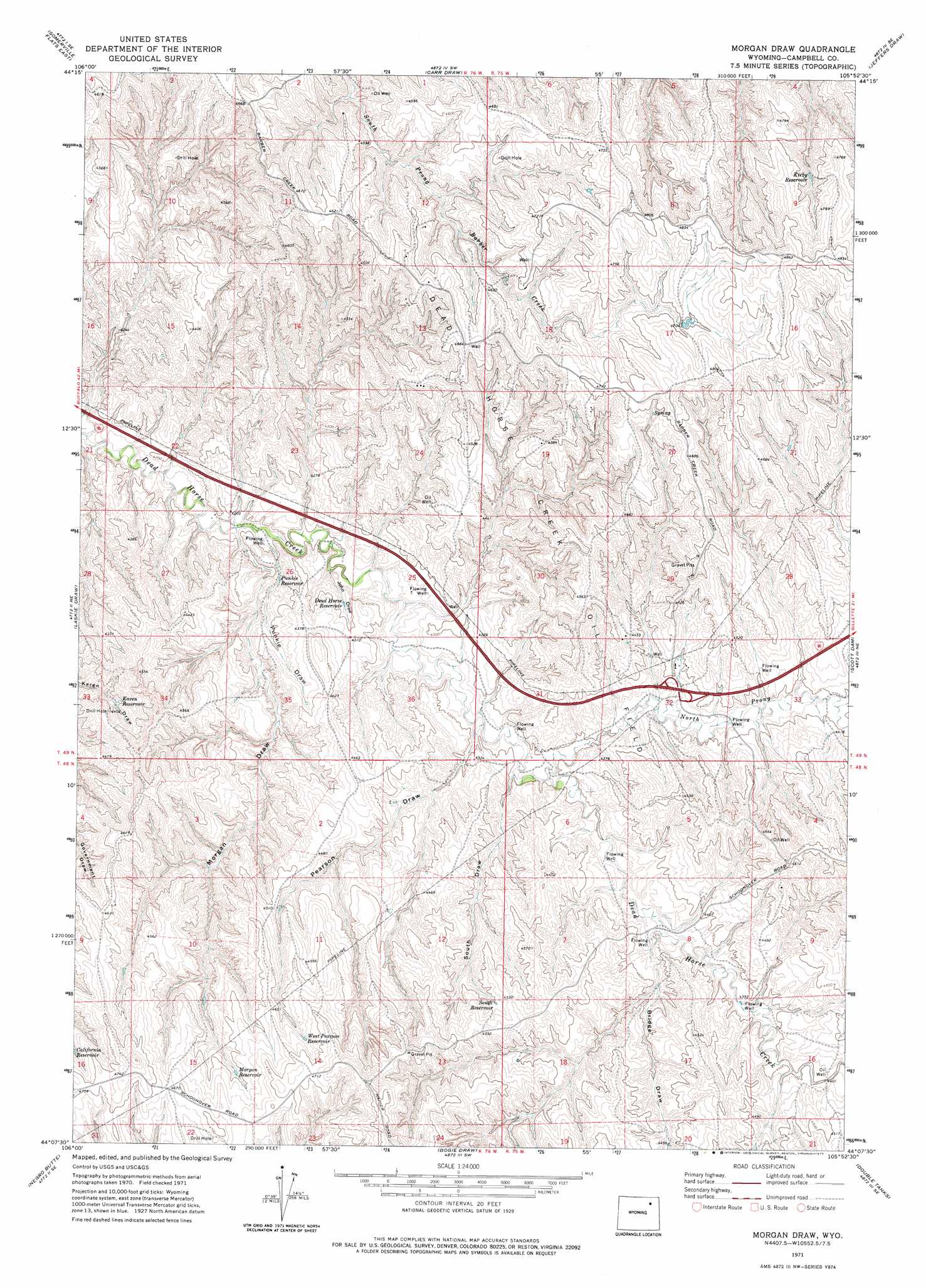
Morgan Draw Topo Map Wyoming
To zoom in, hover over the map of Morgan Draw
USGS Topo Quad 44105b8 - 1:24,000 scale
| Topo Map Name: | Morgan Draw |
| USGS Topo Quad ID: | 44105b8 |
| Print Size: | ca. 21 1/4" wide x 27" high |
| Southeast Coordinates: | 44.125° N latitude / 105.875° W longitude |
| Map Center Coordinates: | 44.1875° N latitude / 105.9375° W longitude |
| U.S. State: | WY |
| Filename: | o44105b8.jpg |
| Download Map JPG Image: | Morgan Draw topo map 1:24,000 scale |
| Map Type: | Topographic |
| Topo Series: | 7.5´ |
| Map Scale: | 1:24,000 |
| Source of Map Images: | United States Geological Survey (USGS) |
| Alternate Map Versions: |
Morgan Draw WY 1971, updated 1975 Download PDF Buy paper map Morgan Draw WY 2012 Download PDF Buy paper map Morgan Draw WY 2015 Download PDF Buy paper map |
1:24,000 Topo Quads surrounding Morgan Draw
Mitchell Draw |
Livingston Draw |
Echeta |
Twentymile Butte |
Oriva Nw |
Somerville Flats West |
Somerville Flats East |
Carr Draw |
Jeffers Draw |
Oriva |
Juniper Draw |
Laskie Draw |
Morgan Draw |
Scott Dam |
Four Bar J Ranch |
Bowman Flat |
Negro Butte |
Bogie Draw |
Double Tanks |
Pleasantdale |
Hoe Ranch |
The Nipple |
Fats Draw |
Wags Pinnacle |
Pepsson Draw |
> Back to 44105a1 at 1:100,000 scale
> Back to 44104a1 at 1:250,000 scale
> Back to U.S. Topo Maps home
Morgan Draw topo map: Gazetteer
Morgan Draw: Oilfields
Dead Horse Creek Oil Field elevation 1351m 4432′Morgan Draw: Reservoirs
Dead Horse Reservoir elevation 1300m 4265′Karen Reservoir elevation 1335m 4379′
Kirby Reservoir elevation 1413m 4635′
Morgan Reservoir elevation 1396m 4580′
Punkie Reservoir elevation 1286m 4219′
South Reservoir elevation 1376m 4514′
West Pearson Reservoir elevation 1412m 4632′
Morgan Draw: Streams
North Prong Dead Horse Creek elevation 1304m 4278′Morgan Draw: Valleys
Bridge Draw elevation 1323m 4340′John Draw elevation 1281m 4202′
Morgan Draw elevation 1271m 4169′
Pearson Draw elevation 1300m 4265′
Punkie Draw elevation 1274m 4179′
South Draw elevation 1305m 4281′
Morgan Draw digital topo map on disk
Buy this Morgan Draw topo map showing relief, roads, GPS coordinates and other geographical features, as a high-resolution digital map file on DVD:
Eastern Wyoming & Western South Dakota
Buy digital topo maps: Eastern Wyoming & Western South Dakota