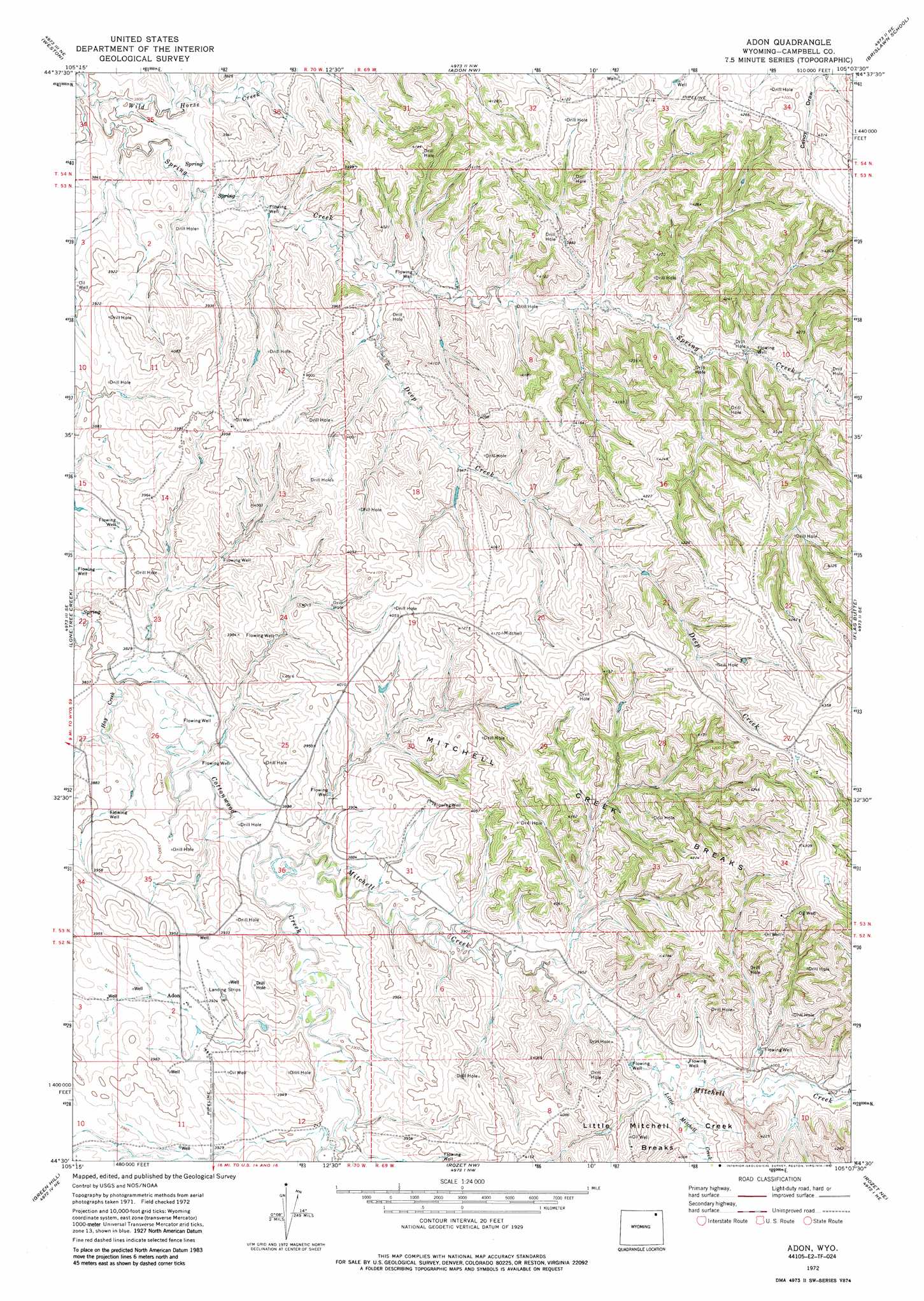
Adon Topo Map Wyoming
To zoom in, hover over the map of Adon
USGS Topo Quad 44105e2 - 1:24,000 scale
| Topo Map Name: | Adon |
| USGS Topo Quad ID: | 44105e2 |
| Print Size: | ca. 21 1/4" wide x 27" high |
| Southeast Coordinates: | 44.5° N latitude / 105.125° W longitude |
| Map Center Coordinates: | 44.5625° N latitude / 105.1875° W longitude |
| U.S. State: | WY |
| Filename: | o44105e2.jpg |
| Download Map JPG Image: | Adon topo map 1:24,000 scale |
| Map Type: | Topographic |
| Topo Series: | 7.5´ |
| Map Scale: | 1:24,000 |
| Source of Map Images: | United States Geological Survey (USGS) |
| Alternate Map Versions: |
Adon WY 1972, updated 1987 Download PDF Buy paper map Adon WY 2012 Download PDF Buy paper map Adon WY 2015 Download PDF Buy paper map |
| FStopo: | US Forest Service topo Adon is available: Download FStopo PDF Download FStopo TIF |
1:24,000 Topo Quads surrounding Adon
Rocky Butte Sw |
Tuttle Draw |
Bowman Hill |
Bonnie Reservoir |
Cedar Ridge |
Oliver Draw |
Weston |
Adon Nw |
Brislawn School |
Garland Hill |
Weston Sw |
Lone Tree Creek |
Adon |
Flag Butte |
Oshoto |
Moyer Springs |
Green Hill |
Rozet Nw |
Rozet Ne |
Edith Creek |
Gillette East |
Fortin Draw |
Rozet |
Rozet Se |
Moorcroft |
> Back to 44105e1 at 1:100,000 scale
> Back to 44104a1 at 1:250,000 scale
> Back to U.S. Topo Maps home
Adon topo map: Gazetteer
Adon: Dams
Barney Number 2 Dam elevation 1189m 3900′Adon: Populated Places
Adon elevation 1194m 3917′Adon: Ranges
Little Mitchell Creek Breaks elevation 1225m 4019′Mitchell Creek Breaks elevation 1286m 4219′
Adon: Reservoirs
Barney Number 2 Reservoir elevation 1189m 3900′Adon: Streams
Deep Creek elevation 1181m 3874′Hay Creek elevation 1160m 3805′
Little Mitchell Creek elevation 1202m 3943′
Mitchell Creek elevation 1174m 3851′
Wild Horse Creek elevation 1155m 3789′
Adon digital topo map on disk
Buy this Adon topo map showing relief, roads, GPS coordinates and other geographical features, as a high-resolution digital map file on DVD:
Eastern Wyoming & Western South Dakota
Buy digital topo maps: Eastern Wyoming & Western South Dakota