Calf Creek Topo Map Wyoming
To zoom in, hover over the map of Calf Creek
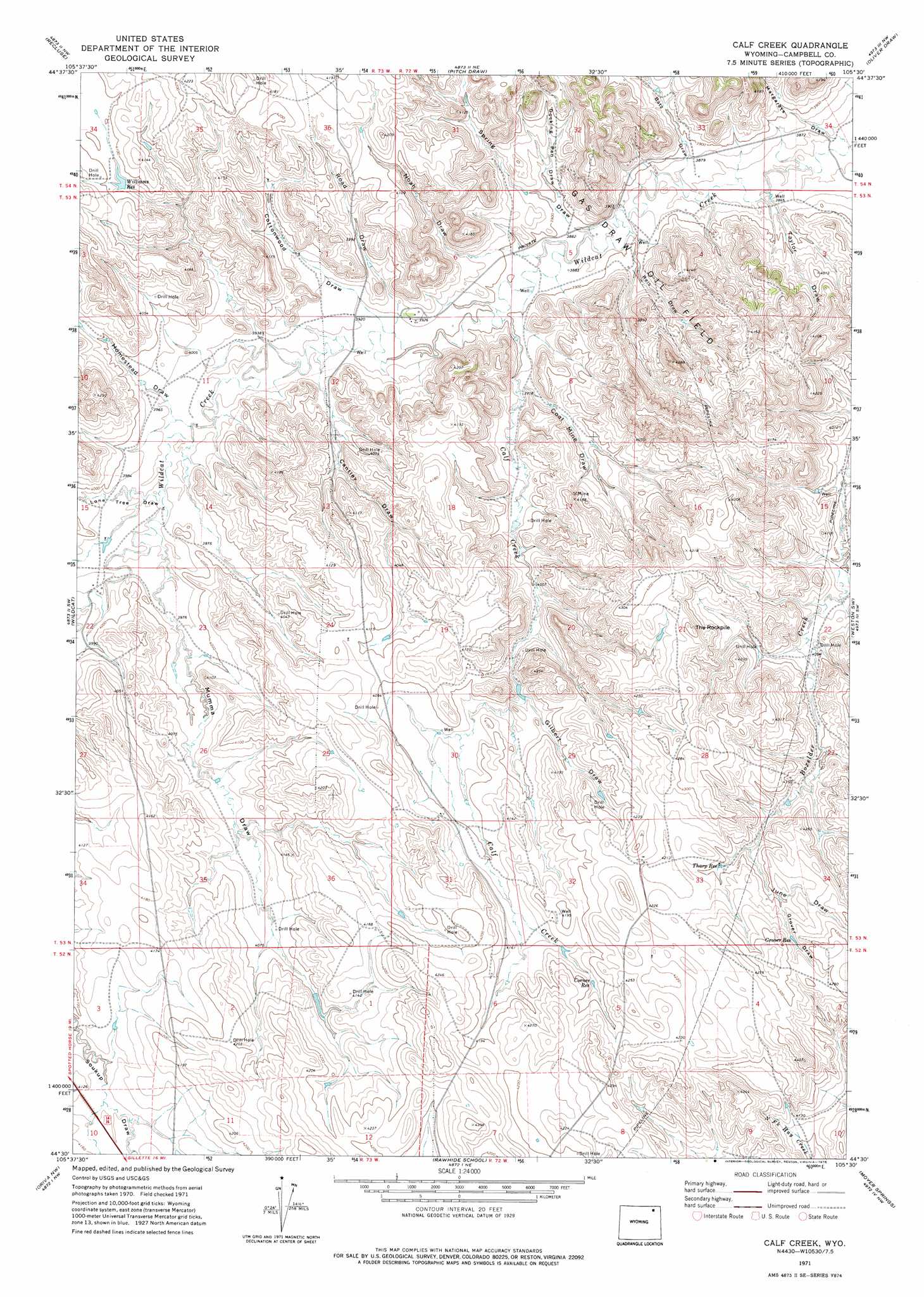
USGS Topo Quad 44105e5 - 1:24,000 scale
| Topo Map Name: | Calf Creek |
| USGS Topo Quad ID: | 44105e5 |
| Print Size: | ca. 21 1/4" wide x 27" high |
| Southeast Coordinates: | 44.5° N latitude / 105.5° W longitude |
| Map Center Coordinates: | 44.5625° N latitude / 105.5625° W longitude |
| U.S. State: | WY |
| Filename: | o44105e5.jpg |
| Download Map JPG Image: | Calf Creek topo map 1:24,000 scale |
| Map Type: | Topographic |
| Topo Series: | 7.5´ |
| Map Scale: | 1:24,000 |
| Source of Map Images: | United States Geological Survey (USGS) |
| Alternate Map Versions: |
Calf Creek WY 1971, updated 1975 Download PDF Buy paper map Calf Creek WY 2012 Download PDF Buy paper map Calf Creek WY 2015 Download PDF Buy paper map |
1:24,000 Topo Quads surrounding Calf Creek
Reservoir Creek |
Homestead Draw Sw |
White Tail Butte |
Rocky Butte Sw |
Tuttle Draw |
Spotted Horse |
Recluse |
Pitch Draw |
Oliver Draw |
Weston |
Truman Draw |
Wildcat |
Calf Creek |
Weston Sw |
Lone Tree Creek |
Twentymile Butte |
Oriva Nw |
Rawhide School |
Moyer Springs |
Green Hill |
Jeffers Draw |
Oriva |
Gillette West |
Gillette East |
Fortin Draw |
> Back to 44105e1 at 1:100,000 scale
> Back to 44104a1 at 1:250,000 scale
> Back to U.S. Topo Maps home
Calf Creek topo map: Gazetteer
Calf Creek: Oilfields
Gas Draw Oil Field elevation 1192m 3910′Calf Creek: Reservoirs
Corner Reservoir elevation 1273m 4176′Grover Reservoir elevation 1290m 4232′
Tharp Reservoir elevation 1277m 4189′
Williams Reservoir elevation 1242m 4074′
Calf Creek: Streams
Calf Creek elevation 1188m 3897′Calf Creek: Summits
The Rockpile elevation 1310m 4297′Calf Creek: Valleys
Batz Draw elevation 1180m 3871′Cantley Draw elevation 1198m 3930′
Coal Mine Draw elevation 1195m 3920′
Cottonwood Draw elevation 1195m 3920′
Docking Pen Draw elevation 1189m 3900′
Gilbert Draw elevation 1238m 4061′
Grover Draw elevation 1280m 4199′
Homestead Draw elevation 1206m 3956′
June Draw elevation 1268m 4160′
Lone Tree Draw elevation 1208m 3963′
Margarets Draw elevation 1171m 3841′
Mumma Draw elevation 1208m 3963′
Noah Draw elevation 1197m 3927′
Reis Draw elevation 1182m 3877′
Road Draw elevation 1198m 3930′
Spring Draw elevation 1183m 3881′
Taylor Draw elevation 1176m 3858′
Calf Creek digital topo map on disk
Buy this Calf Creek topo map showing relief, roads, GPS coordinates and other geographical features, as a high-resolution digital map file on DVD:
Eastern Wyoming & Western South Dakota
Buy digital topo maps: Eastern Wyoming & Western South Dakota