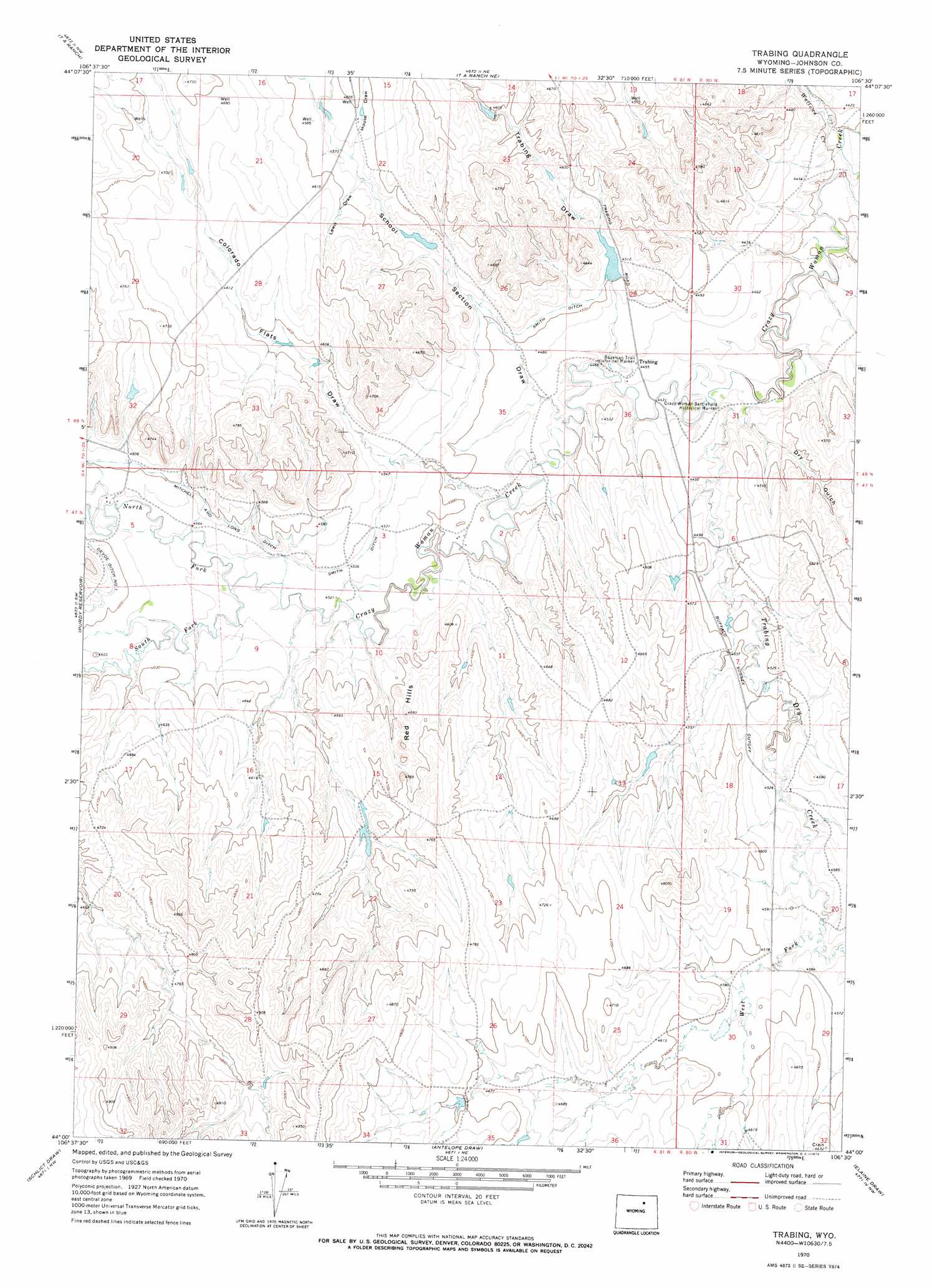
Trabing Topo Map Wyoming
To zoom in, hover over the map of Trabing
USGS Topo Quad 44106a5 - 1:24,000 scale
| Topo Map Name: | Trabing |
| USGS Topo Quad ID: | 44106a5 |
| Print Size: | ca. 21 1/4" wide x 27" high |
| Southeast Coordinates: | 44° N latitude / 106.5° W longitude |
| Map Center Coordinates: | 44.0625° N latitude / 106.5625° W longitude |
| U.S. State: | WY |
| Filename: | o44106a5.jpg |
| Download Map JPG Image: | Trabing topo map 1:24,000 scale |
| Map Type: | Topographic |
| Topo Series: | 7.5´ |
| Map Scale: | 1:24,000 |
| Source of Map Images: | United States Geological Survey (USGS) |
| Alternate Map Versions: |
Trabing WY 1970, updated 1973 Download PDF Buy paper map Trabing WY 2012 Download PDF Buy paper map Trabing WY 2015 Download PDF Buy paper map |
1:24,000 Topo Quads surrounding Trabing
North Ridge |
Buffalo |
Buffalo Se |
Pine Gulch |
Bear Draw |
Klondike Ranch |
T A Ranch |
Ta Ranch Ne |
Crazy Woman Ranch |
Ploessers Draw |
Robinson Canyon |
Purdy Reservoir |
Trabing |
Brown Ranch |
Boon |
The Horn |
Schlicht Draw |
Antelope Draw |
Elaine Draw |
Provence Ranch |
Mayoworth |
Hibbard Draw |
Dry Creek Reservoir |
Fourmile Reservoir |
Soldier Creek |
> Back to 44106a1 at 1:100,000 scale
> Back to 44106a1 at 1:250,000 scale
> Back to U.S. Topo Maps home
Trabing topo map: Gazetteer
Trabing: Canals
Mitchell and Long Ditch elevation 1403m 4603′Smith Ditch elevation 1376m 4514′
Trabing: Dams
Smith Number 1 Dam elevation 1431m 4694′Trabing Dam elevation 1361m 4465′
Zezas Dam elevation 1386m 4547′
Trabing: Parks
Bozeman Trail Historical Marker elevation 1359m 4458′Trabing: Ranges
Red Hills elevation 1425m 4675′Trabing: Reservoirs
Smith Reservoir Number 1 elevation 1431m 4694′Trabing Reservoir elevation 1361m 4465′
Zezas Reservoir elevation 1386m 4547′
Trabing: Streams
South Fork Crazy Woman Creek elevation 1382m 4534′Trabing Dry Creek elevation 1342m 4402′
Wallows Creek elevation 1330m 4363′
West Fork Trabing Dry Creek elevation 1386m 4547′
Trabing: Valleys
Colorado Flats Draw elevation 1383m 4537′Dry Gulch elevation 1349m 4425′
Lewis Draw elevation 1392m 4566′
School Section Draw elevation 1356m 4448′
Trabing Draw elevation 1369m 4491′
Trabing digital topo map on disk
Buy this Trabing topo map showing relief, roads, GPS coordinates and other geographical features, as a high-resolution digital map file on DVD:
Eastern Wyoming & Western South Dakota
Buy digital topo maps: Eastern Wyoming & Western South Dakota