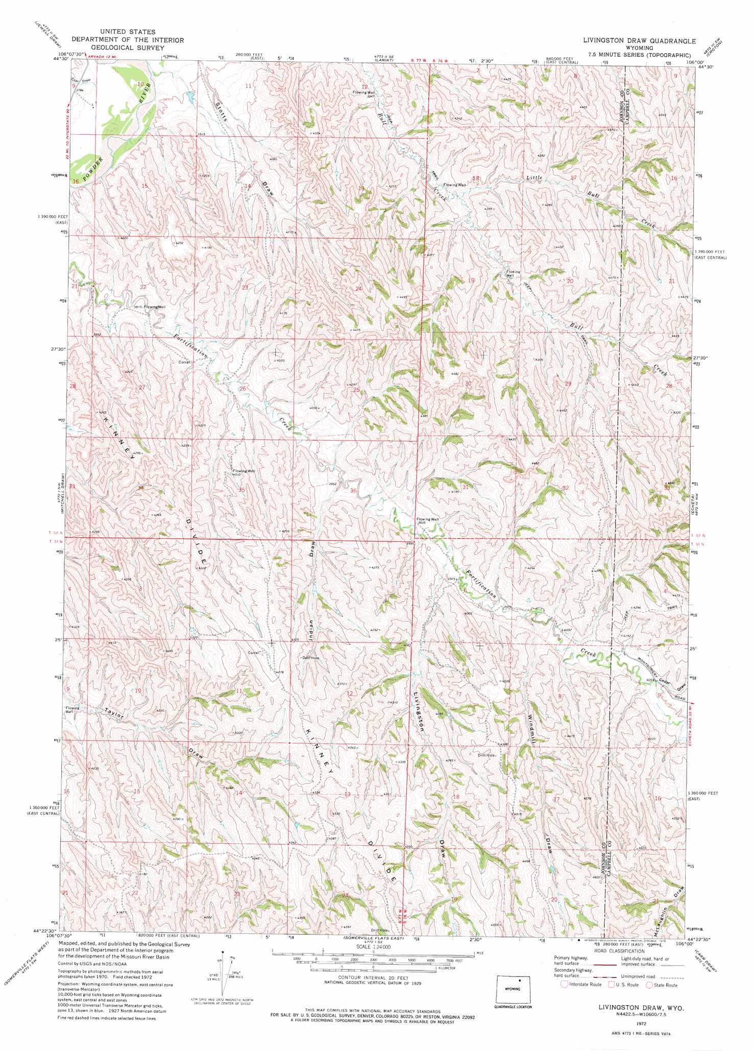
Livingston Draw Topo Map Wyoming
To zoom in, hover over the map of Livingston Draw
USGS Topo Quad 44106d1 - 1:24,000 scale
| Topo Map Name: | Livingston Draw |
| USGS Topo Quad ID: | 44106d1 |
| Print Size: | ca. 21 1/4" wide x 27" high |
| Southeast Coordinates: | 44.375° N latitude / 106° W longitude |
| Map Center Coordinates: | 44.4375° N latitude / 106.0625° W longitude |
| U.S. State: | WY |
| Filename: | o44106d1.jpg |
| Download Map JPG Image: | Livingston Draw topo map 1:24,000 scale |
| Map Type: | Topographic |
| Topo Series: | 7.5´ |
| Map Scale: | 1:24,000 |
| Source of Map Images: | United States Geological Survey (USGS) |
| Alternate Map Versions: |
Livingston Draw WY 1972, updated 1975 Download PDF Buy paper map Livingston Draw WY 2012 Download PDF Buy paper map Livingston Draw WY 2015 Download PDF Buy paper map |
1:24,000 Topo Quads surrounding Livingston Draw
Leiter |
Arvada |
Arvada Ne |
Larey Draw |
Spotted Horse |
Arpan Butte |
Jewell Draw |
Lariat |
Croton |
Truman Draw |
Floate Draw |
Mitchell Draw |
Livingston Draw |
Echeta |
Twentymile Butte |
Bear Draw |
Somerville Flats West |
Somerville Flats East |
Carr Draw |
Jeffers Draw |
Ploessers Draw |
Juniper Draw |
Laskie Draw |
Morgan Draw |
Scott Dam |
> Back to 44106a1 at 1:100,000 scale
> Back to 44106a1 at 1:250,000 scale
> Back to U.S. Topo Maps home
Livingston Draw topo map: Gazetteer
Livingston Draw: Dams
Huff Dam elevation 1297m 4255′Puff Dam elevation 1327m 4353′
Livingston Draw: Reservoirs
Huff Reservoir elevation 1297m 4255′Puff Reservoir elevation 1327m 4353′
Livingston Draw: Streams
Little Bull Creek elevation 1196m 3923′Livingston Draw: Valleys
Cedar Draw elevation 1239m 4064′Coal Draw elevation 1147m 3763′
Indian Draw elevation 1198m 3930′
Livingston Draw elevation 1209m 3966′
Windmill Draw elevation 1221m 4005′
Livingston Draw digital topo map on disk
Buy this Livingston Draw topo map showing relief, roads, GPS coordinates and other geographical features, as a high-resolution digital map file on DVD:
Eastern Wyoming & Western South Dakota
Buy digital topo maps: Eastern Wyoming & Western South Dakota