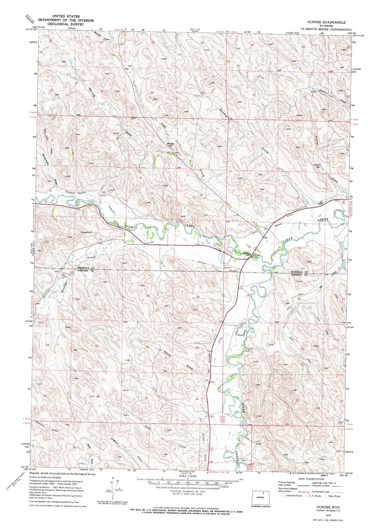
Ucross Topo Map Wyoming
To zoom in, hover over the map of Ucross
USGS Topo Quad 44106e5 - 1:24,000 scale
| Topo Map Name: | Ucross |
| USGS Topo Quad ID: | 44106e5 |
| Print Size: | ca. 21 1/4" wide x 27" high |
| Southeast Coordinates: | 44.5° N latitude / 106.5° W longitude |
| Map Center Coordinates: | 44.5625° N latitude / 106.5625° W longitude |
| U.S. State: | WY |
| Filename: | o44106e5.jpg |
| Download Map JPG Image: | Ucross topo map 1:24,000 scale |
| Map Type: | Topographic |
| Topo Series: | 7.5´ |
| Map Scale: | 1:24,000 |
| Source of Map Images: | United States Geological Survey (USGS) |
| Alternate Map Versions: |
Ucross WY 1970, updated 1973 Download PDF Buy paper map Ucross WY 1970, updated 1973 Download PDF Buy paper map Ucross WY 2012 Download PDF Buy paper map Ucross WY 2015 Download PDF Buy paper map |
1:24,000 Topo Quads surrounding Ucross
Wyarno |
Jones Draw |
S R Springs |
Shuler Draw |
Gardner Gulch |
Buffalo Run Creek |
Verona |
Ulm |
Clearmont |
Leiter |
Banner |
Horse Hill |
Ucross |
Julio Draw |
Arpan Butte |
Lake De Smet West |
Lake De Smet East |
Buffalo Ne |
Fredrick Draw |
Floate Draw |
North Ridge |
Buffalo |
Buffalo Se |
Pine Gulch |
Bear Draw |
> Back to 44106e1 at 1:100,000 scale
> Back to 44106a1 at 1:250,000 scale
> Back to U.S. Topo Maps home
Ucross topo map: Gazetteer
Ucross: Canals
Athorpe Rogers Ditch elevation 1276m 4186′Big Bonanza Ditch elevation 1265m 4150′
Boxelder Ditch elevation 1291m 4235′
Dunlap Ditch elevation 1267m 4156′
Ucross: Dams
Little Red Dam elevation 1237m 4058′Little Red Number 2 Dam elevation 1243m 4078′
Ucross: Mines
Garretson Mine elevation 1367m 4484′Holmberg Mine elevation 1323m 4340′
Ucross: Populated Places
Ucross elevation 1244m 4081′Ucross: Reservoirs
Little Red Reservoir elevation 1237m 4058′Little Red Reservoir Number 2 elevation 1243m 4078′
Pitsch Reservoir elevation 1258m 4127′
Ucross: Streams
Boxelder Creek elevation 1256m 4120′Coal Creek elevation 1236m 4055′
Deep Creek elevation 1285m 4215′
Donkey Creek elevation 1232m 4041′
Piney Creek elevation 1234m 4048′
Ucross: Summits
Blazer Hill elevation 1324m 4343′Ucross: Valleys
Bourret Draw elevation 1341m 4399′Butterfield Draw elevation 1278m 4192′
Copps Draw elevation 1271m 4169′
Fowler Draw elevation 1244m 4081′
Ike Draw elevation 1249m 4097′
Spring Draw elevation 1274m 4179′
Twin Fork Draw elevation 1295m 4248′
Ucross digital topo map on disk
Buy this Ucross topo map showing relief, roads, GPS coordinates and other geographical features, as a high-resolution digital map file on DVD:
Eastern Wyoming & Western South Dakota
Buy digital topo maps: Eastern Wyoming & Western South Dakota