Banner Topo Map Wyoming
To zoom in, hover over the map of Banner
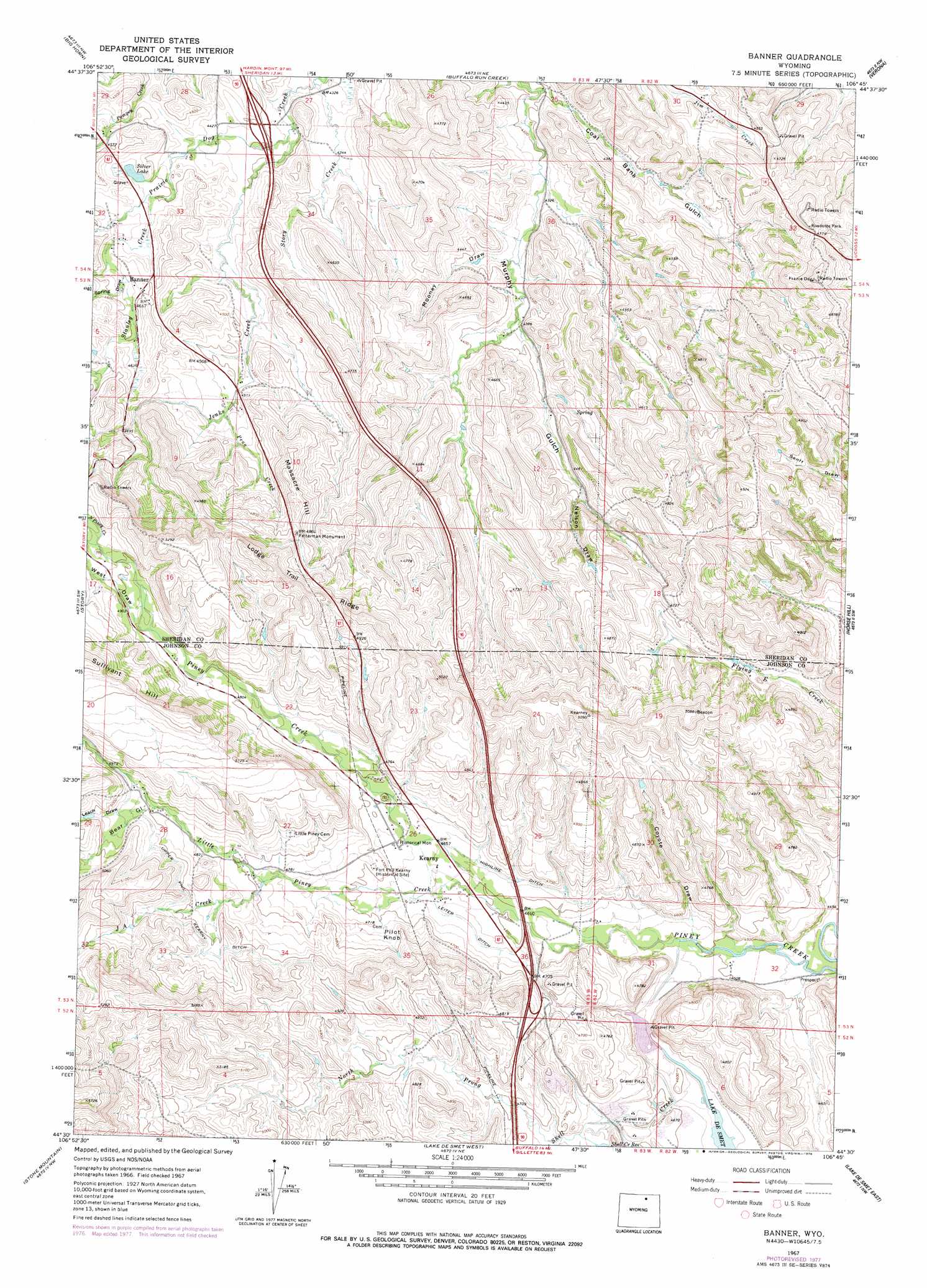
USGS Topo Quad 44106e7 - 1:24,000 scale
| Topo Map Name: | Banner |
| USGS Topo Quad ID: | 44106e7 |
| Print Size: | ca. 21 1/4" wide x 27" high |
| Southeast Coordinates: | 44.5° N latitude / 106.75° W longitude |
| Map Center Coordinates: | 44.5625° N latitude / 106.8125° W longitude |
| U.S. State: | WY |
| Filename: | o44106e7.jpg |
| Download Map JPG Image: | Banner topo map 1:24,000 scale |
| Map Type: | Topographic |
| Topo Series: | 7.5´ |
| Map Scale: | 1:24,000 |
| Source of Map Images: | United States Geological Survey (USGS) |
| Alternate Map Versions: |
Banner WY 1967, updated 1972 Download PDF Buy paper map Banner WY 1967, updated 1978 Download PDF Buy paper map Banner WY 1967, updated 1978 Download PDF Buy paper map Banner WY 2012 Download PDF Buy paper map Banner WY 2015 Download PDF Buy paper map |
1:24,000 Topo Quads surrounding Banner
Hultz Draw |
Sheridan |
Wyarno |
Jones Draw |
S R Springs |
Beaver Creek Hills |
Big Horn |
Buffalo Run Creek |
Verona |
Ulm |
Little Goose Peak |
Story |
Banner |
Horse Hill |
Ucross |
Willow Park Reservoir |
Stone Mountain |
Lake De Smet West |
Lake De Smet East |
Buffalo Ne |
Lake Angeline |
Hunter Mesa |
North Ridge |
Buffalo |
Buffalo Se |
> Back to 44106e1 at 1:100,000 scale
> Back to 44106a1 at 1:250,000 scale
> Back to U.S. Topo Maps home
Banner topo map: Gazetteer
Banner: Canals
Highline Ditch elevation 1417m 4648′Leiter Ditch elevation 1413m 4635′
Upper Phil Kearny Ditch elevation 1498m 4914′
Banner: Dams
Lake Desmet Dam elevation 1450m 4757′Reynolds Piney Creek Diversion Dam elevation 1407m 4616′
Banner: Lakes
Silver Lake elevation 1376m 4514′Banner: Mines
Hearney Pit Mine elevation 1451m 4760′Banner: Parks
Fetterman Monument elevation 1478m 4849′Banner: Populated Places
Banner elevation 1396m 4580′Kearny elevation 1414m 4639′
Banner: Reservoirs
Lake Desmet elevation 1450m 4757′Reynolds Piney Creek Diversion Dam elevation 1407m 4616′
Banner: Ridges
Lodge Trail Ridge elevation 1524m 5000′Banner: Streams
J A Creek elevation 1456m 4776′Jenks Creek elevation 1336m 4383′
Little Piney Creek elevation 1385m 4543′
North Piney Creek elevation 1501m 4924′
North Prong Shell Creek elevation 1417m 4648′
Peno Creek elevation 1375m 4511′
Shell Creek elevation 1375m 4511′
South Piney Creek elevation 1501m 4924′
Stanley Creek elevation 1373m 4504′
Story Creek elevation 1318m 4324′
Banner: Summits
Massacre Hill elevation 1480m 4855′Pilot Knob elevation 1463m 4799′
Sullivant Hill elevation 1597m 5239′
Banner: Valleys
Bear Gulch elevation 1489m 4885′Coal Bank Gulch elevation 1311m 4301′
Coyote Draw elevation 1389m 4557′
Leach Draw elevation 1501m 4924′
Mooney Draw elevation 1326m 4350′
Nelson Draw elevation 1367m 4484′
Orr Gulch elevation 1422m 4665′
Spring Draw elevation 1391m 4563′
Spring Draw elevation 1391m 4563′
West Draw elevation 1489m 4885′
Banner digital topo map on disk
Buy this Banner topo map showing relief, roads, GPS coordinates and other geographical features, as a high-resolution digital map file on DVD:
Eastern Wyoming & Western South Dakota
Buy digital topo maps: Eastern Wyoming & Western South Dakota