Hyatt Ranch Topo Map Wyoming
To zoom in, hover over the map of Hyatt Ranch
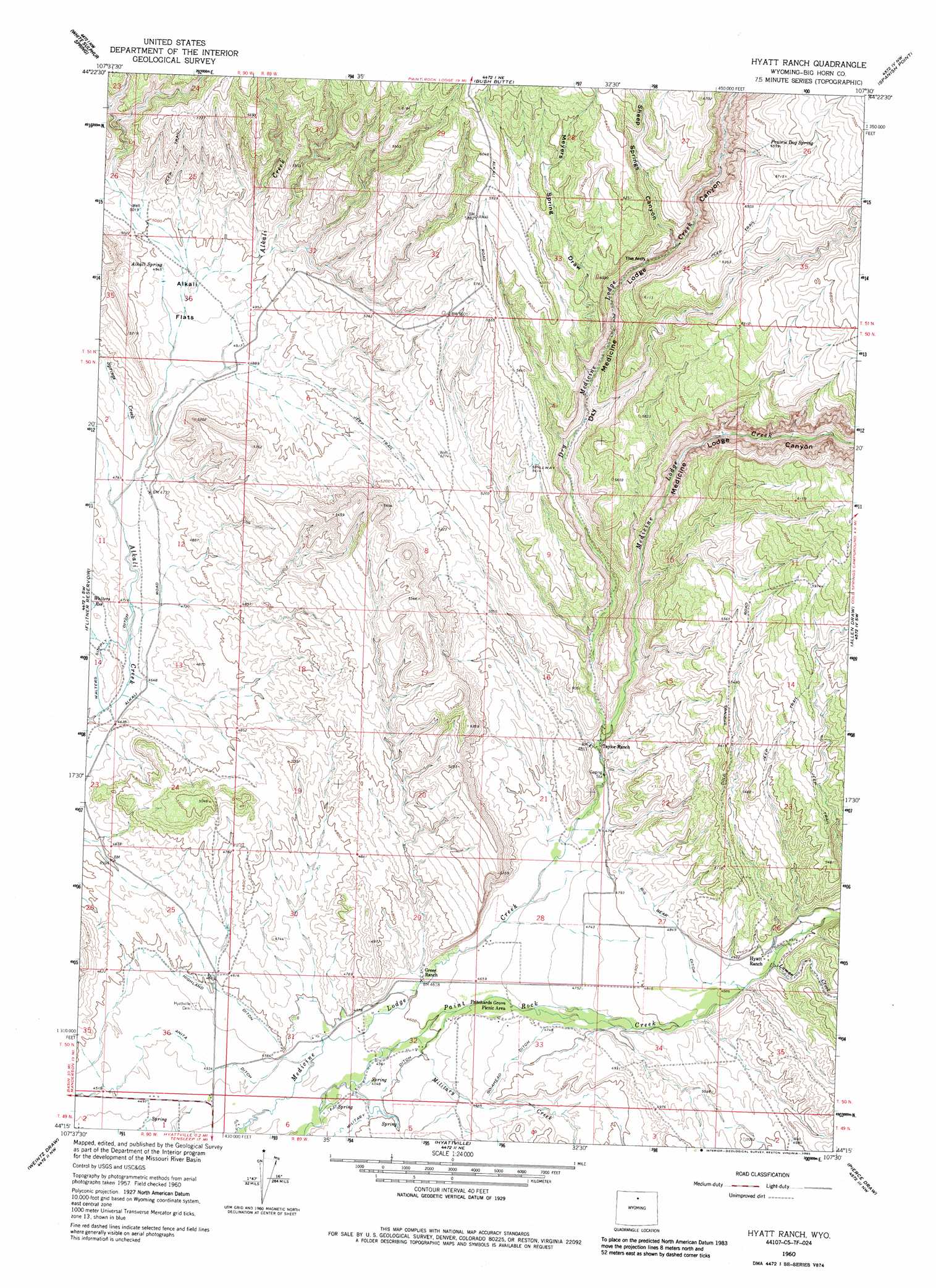
USGS Topo Quad 44107c5 - 1:24,000 scale
| Topo Map Name: | Hyatt Ranch |
| USGS Topo Quad ID: | 44107c5 |
| Print Size: | ca. 21 1/4" wide x 27" high |
| Southeast Coordinates: | 44.25° N latitude / 107.5° W longitude |
| Map Center Coordinates: | 44.3125° N latitude / 107.5625° W longitude |
| U.S. State: | WY |
| Filename: | o44107c5.jpg |
| Download Map JPG Image: | Hyatt Ranch topo map 1:24,000 scale |
| Map Type: | Topographic |
| Topo Series: | 7.5´ |
| Map Scale: | 1:24,000 |
| Source of Map Images: | United States Geological Survey (USGS) |
| Alternate Map Versions: |
Hyatt Ranch WY 1960, updated 1962 Download PDF Buy paper map Hyatt Ranch WY 1960, updated 1973 Download PDF Buy paper map Hyatt Ranch WY 1960, updated 1985 Download PDF Buy paper map Hyatt Ranch WY 1960, updated 1985 Download PDF Buy paper map Hyatt Ranch WY 2012 Download PDF Buy paper map Hyatt Ranch WY 2015 Download PDF Buy paper map |
1:24,000 Topo Quads surrounding Hyatt Ranch
Shell |
Black Mountain |
Shell Falls |
Shell Reservoir |
Dome Lake |
Manderson Ne |
White Sulphur Spring |
Bush Butte |
Spanish Point |
Shell Lake |
Manderson Se |
Flitner Reservoir |
Hyatt Ranch |
Allen Draw |
Lake Solitude |
Mcdermotts Butte |
Weintz Draw |
Hyattville |
Pierce Draw |
Brokenback Narrows |
Worland Se |
Broom Draw |
Wild Horse Hill |
Ten Sleep |
Old Maid Gulch |
> Back to 44107a1 at 1:100,000 scale
> Back to 44106a1 at 1:250,000 scale
> Back to U.S. Topo Maps home
Hyatt Ranch topo map: Gazetteer
Hyatt Ranch: Arches
The Arch elevation 1710m 5610′Hyatt Ranch: Canals
Big Bear Ditch elevation 1487m 4878′Go-Ahead Ditch elevation 1451m 4760′
Highland Ditch elevation 1400m 4593′
Military Ditch elevation 1401m 4596′
Walters Supply Ditch elevation 1414m 4639′
Hyatt Ranch: Dams
Enlargement of the Walters Dam elevation 1420m 4658′Hyatt Ranch: Flats
Alkali Flats elevation 1507m 4944′Hyatt Ranch: Mines
Paintrock Area Mine elevation 1402m 4599′Shirran Pit elevation 1414m 4639′
Hyatt Ranch: Ranges
Medicine Lodge Big Game Winter Range elevation 2023m 6637′Hyatt Ranch: Reservoirs
Enlargement of the Walters Reservoir elevation 1420m 4658′Walters Reservoir elevation 1419m 4655′
Hyatt Ranch: Springs
Alkali Spring elevation 1511m 4957′Prairie Dog Spring elevation 2001m 6564′
Hyatt Ranch: Streams
Dry Medicine Lodge Creek elevation 1460m 4790′Luman Creek elevation 1511m 4957′
Military Creek elevation 1400m 4593′
Springs Creek elevation 1464m 4803′
Hyatt Ranch: Valleys
Buck Draw elevation 1491m 4891′Dry Medicine Lodge Canyon elevation 1462m 4796′
Medicine Lodge Canyon elevation 1463m 4799′
Myers Spring Draw elevation 1630m 5347′
Sheep Springs Canyon elevation 1710m 5610′
Hyatt Ranch digital topo map on disk
Buy this Hyatt Ranch topo map showing relief, roads, GPS coordinates and other geographical features, as a high-resolution digital map file on DVD:
Eastern Wyoming & Western South Dakota
Buy digital topo maps: Eastern Wyoming & Western South Dakota